
San Gimignano is a small walled medieval hill town in the province of Siena, Tuscany, north-central Italy. Known as the Town of Fine Towers, San Gimignano is famous for its medieval architecture, unique in the preservation of about a dozen of its tower houses, which, with its hilltop setting and encircling walls, form "an unforgettable skyline". Within the walls, the well-preserved buildings include notable examples of both Romanesque and Gothic architecture, with outstanding examples of secular buildings as well as churches. The Palazzo Comunale, the Collegiate Church and Church of Sant' Agostino contain frescos, including cycles dating from the 14th and 15th centuries. The "Historic Centre of San Gimignano" is a UNESCO World Heritage Site. The town also is known for saffron, the Golden Ham, and its white wine, Vernaccia di San Gimignano, produced from the ancient variety of Vernaccia grape which is grown on the sandstone hillsides of the area.
Umbertide is a town and comune (township) of Italy, in the province of Perugia and in northwestern Umbria, at the confluence of the Reggia river and the Tiber. It is 30 km (19 mi) North of Perugia and 20 km (12 mi) South of Città di Castello. With 16,607 inhabitants according to the 2017 census, Umbertide is one of the larger towns of Umbria; and basically flat. It is an industrial center producing machine tools, textiles, packaging material, and ceramics. Olive oil is produced, especially in Pierantonio and in its southwestern part.

Castiglion Fiorentino is a small, walled city in eastern Tuscany, Italy, in the province of Arezzo, between the cities of Arezzo and Cortona. It is known for its annual festivals and its Etruscan archeological site.
Tuscania is a town and comune in the province of Viterbo, Lazio Region, Italy. Until the late 19th century the town was known as Toscanella.

Montepulciano is a medieval and Renaissance hill town and comune in the Italian province of Siena in southern Tuscany. It sits high on a 605-metre (1,985 ft) limestone ridge, 13 kilometres (8 mi) east of Pienza, 70 kilometres (43 mi) southeast of Siena, 124 kilometres (77 mi) southeast of Florence, and 186 kilometres (116 mi) north of Rome by car.

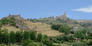
Sorano is a town and comune in the province of Grosseto, southern Tuscany (Italy).

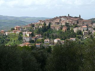
Cetona is a town and comune in the southern part province of Siena, Tuscany, in an area where Umbria and Lazio meet.

Asciano is a comune and hill town in the province of Siena in the Italian region Tuscany. It is located at the centre of the Crete senesi between the river Ombrone and the torrent Copra, some 30 kilometres (19 mi) southeast of the town of Siena by rail.

Massa Marittima is a town and comune of the province of Grosseto, southern Tuscany, Italy, 49 km NNW of Grosseto.

Montefiascone is a town and comune of the province of Viterbo, in Lazio, central Italy. It stands on a hill on the southeast side of Lake Bolsena, about 100 km (60 mi) north of Rome.

San Miniato is a town and comune in the province of Pisa, in the region of Tuscany, Italy.

Poggibonsi is a town in the province of Siena, Tuscany, central Italy. It is located on the river Elsa and is the main centre of the Valdelsa Valley.

Foiano della Chiana is a small agricultural town in eastern Tuscany, in the province of Arezzo, between the cities of Sinalunga and Cortona. It is well known for its annual carnival.
Bassano Romano is a town and comune situated in the hills of Monti Sabatini in the province of Viterbo, in northern Lazio (Italy). With its origins about 1000 as the agricultural hamlet of Bassano di Sutri the village's future was founded in 1160 by the wealthy landowner Enotrio Serco, who initiated the construction at the top of the slope of a fortified residence that over the centuries became a princely dwelling, frescoed by famous artists. In 1482 Pope Sixtus IV assigned the Foedus Bassani to the Anguillara, Roman patricians . The growth of the comune redoubled after 1565, when the signory was reassigned by Pope Clement VIII to the Giustiniani, merchants of Genoese origin settled at Rome. In 1605 the signory was raised to a marquessate: a hunting lodge called "La Rocca", granaries, a stone bridge and the church dedicated to San Vincenzo were all constructed. During the Giustiniani residence, artists were commissioned to carry out frescoes: Francesco Albani, Domenico Zampieri "Domenichino" and Antonio Tempesta are all represented. In 1644, a bulla of Pope Innocent X made the marchese of Bassano a prince, and the flock of papal and noble visitors included James Stuart, pretender to the thrones of England and Scotland. In 1735, under Giustiniani patronage the maiolica manufactory of Bartolomeo Terchi was transferred here from Siena.

San Casciano in Val di Pesa is a comune (municipality) in the Metropolitan City of Florence in the Italian region Tuscany, located about 15 kilometres (9 mi) southwest of Florence.

Castellina in Chianti is a comune (municipality) of c. 2,800 inhabitants in the province of Siena, in the Italian region Tuscany, located about 35 kilometres (22 mi) south of Florence and about 15 kilometres (9 mi) northwest of Siena. It is part of the Chianti Hills, between the valleys of the Arbia, Pesa and Elsa rivers.

Chianciano Terme is a comune (municipality) in the Province of Siena in the Italian region Tuscany, located about 90 kilometres (56 mi) southeast of Florence and about 50 kilometres (31 mi) southeast of Siena. It is located between the Valdichiana and the Val d'Orcia.

Gavorrano is a mountain-side comune (municipality) in the Province of Grosseto in the western Italian region of Tuscany, located about 100 km (62 mi) southwest of Florence and about 25 km (16 mi) northwest of Grosseto. Gavorrano borders the municipalities of Castiglione della Pescaia, Grosseto, Massa Marittima, Roccastrada and Scarlino.
Santa Fiora is a comune (municipality) in the Province of Grosseto, in the Italian region of Tuscany, located about 110 kilometres southeast of Florence and about 40 km (25 mi) east of Grosseto. Santa Fiora borders the following municipalities: Abbadia San Salvatore, Arcidosso, Castel del Piano, Castell'Azzara, Piancastagnaio, Roccalbegna, Semproniano.
Seggiano is a comune (municipality) in the Province of Grosseto in the Italian region Tuscany, located about 100 kilometres (62 mi) south of Florence and about 40 kilometres (25 mi) northeast of Grosseto.


