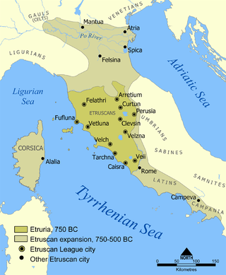
Etruria was a region of Central Italy delimited by the rivers Arno and Tiber, an area that covered what is now most of Tuscany, northern Lazio, and north-western Umbria.
This article deals with the history of Tuscany.

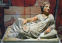
Cloelia was a legendary woman from the early history of ancient Rome.

Cortona is a town and comune in the province of Arezzo, in Tuscany, Italy. It is the main cultural and artistic centre of the Val di Chiana after Arezzo.
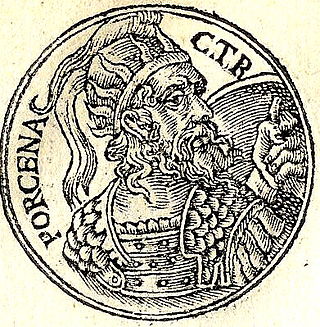
Lars Porsena was an Etruscan king (lar) known for his war against the city of Rome. He ruled over the city of Clusium. There are no established dates for his rule, but Roman sources often place the war at around 508 BC.

Volterra is a walled mountaintop town in the Tuscany region of Italy. Its history dates from before the 8th century BC and it has substantial structures from the Etruscan, Roman, and Medieval periods.
Belinus the Great was a legendary king of the Britons, as recounted by Geoffrey of Monmouth. He was the son of Dunvallo Molmutius and brother of Brennius and came to power in 390 BC. He was probably named after the ancient god Belenus.
Brennius was a legendary king of Northumberland and Allobroges, as recounted by Geoffrey of Monmouth. He was the son of Dunvallo Molmutius and brother of Belinus, probably based upon one or both of the historical Brenni. He came to power in 390BC.
The province of Pisa is a province in the Tuscany region of Italy. Its capital is the city of Pisa. With an area of 2,448 square kilometres (945 sq mi) and a total population of 421,642, it is the second most populous and fifth largest province of Tuscany. It is subdivided into 37 comuni.
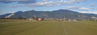
Clusium was an ancient city in Italy, one of several found at the site. The current municipality of Chiusi (Tuscany) partly overlaps this Roman walled city. The Roman city remodeled an earlier Etruscan city, Clevsin, found in the territory of a prehistoric culture, possibly also Etruscan or proto-Etruscan. The site is located in northern central Italy on the west side of the Apennines.

Montepulciano is a medieval and Renaissance hill town and comune in the Italian province of Siena in southern Tuscany. It sits high on a 605-metre (1,985 ft) limestone ridge, 13 kilometres (8 mi) east of Pienza, 70 kilometres (43 mi) southeast of Siena, 124 kilometres (77 mi) southeast of Florence, and 186 kilometres (116 mi) north of Rome by car.
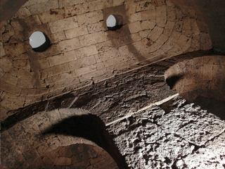
The tomb of the Etruscan king Lars Porsena is a legendary ancient building in what is now central Italy. Allegedly built around 500 BCE at Clusium, and was described as follows by the Roman writer Marcus Varro :
Porsena was buried below the city of Clusium in the place where he had built a square monument of dressed stones. Each side was three hundred feet in length and fifty in height, and beneath the base there was an inextricable labyrinth, into which, if any-body entered without a clue of thread, he could never discover his way out. Above this square building there stand five pyramids, one at each corner and one in the centre, seventy-five feet [c. 22 meters] broad at the base and one hundred and fifty feet [c. 44 meters] high. These pyramids so taper in shape that upon the top of all of them together there is supported a brazen globe, and upon that again a petasus from which bells are suspended by chains. These make a tinkling sound when blown about by the wind, as was done in bygone times at Dodona. Upon this globe there are four more pyramids, each a hundred feet [c. 30 meters] in height, and above them is a platform on which are five more pyramids.

Ranuccio Bianchi Bandinelli was an Italian archaeologist and art historian.

Castellina in Chianti is a comune (municipality) of c. 2,800 inhabitants in the province of Siena, in the Italian region Tuscany, located about 35 kilometres (22 mi) south of Florence and about 15 kilometres (9 mi) northwest of Siena. It is part of the Chianti Hills, between the valleys of the Arbia, Pesa and Elsa rivers.

Chianciano Terme is a comune (municipality) in the Province of Siena in the Italian region Tuscany, located about 90 kilometres (56 mi) southeast of Florence and about 50 kilometres (31 mi) southeast of Siena. It is located between the Valdichiana and the Val d'Orcia.

San Casciano dei Bagni is a comune (municipality) in the Province of Siena in the Italian region of Tuscany, located about 110 km (68 mi) southeast of Florence and about 70 km (43 mi) southeast of Siena. It is one of I Borghi più belli d'Italia.

Civitella Paganico is a comune (municipality) in the Province of Grosseto in the Italian region Tuscany. It features agricultural land, the main economy of the region, interspersed with dense forest. It is home to a variety of plant and animal species. Civitella Paganico is home to the Petriolo hot springs, which have been enjoyed by travelers for thousands of years.

Sovana is a small town in southern Tuscany, Italy, a frazione of Sorano, a comune in the province of Grosseto. It is one of I Borghi più belli d'Italia.

Titus Herminius, surnamed Aquilinus, was one of the heroes of the Roman Republic. He participated in two of the most famous conflicts that attended the birth of the Republic, and was elected consul in 506 BC. However, his greatest fame was won as one of the defenders of the Sublician bridge against the army of Lars Porsena, the King of Clusium.
La Befa is a hamlet in Tuscany, central Italy, administratively a frazione of the comune of Murlo, province of Siena. At the time of the 2001 census its population was 26.