Sit River

Last updated

Coordinates: 58°18′40.5″N37°52′52.6″E / 58.311250°N 37.881278°E / 58.311250; 37.881278

Geographic coordinate system Coordinate system

A geographic coordinate system is a coordinate system that enables every location on Earth to be specified by a set of numbers, letters or symbols. The coordinates are often chosen such that one of the numbers represents a vertical position and two or three of the numbers represent a horizontal position; alternatively, a geographic position may be expressed in a combined three-dimensional Cartesian vector. A common choice of coordinates is latitude, longitude and elevation. To specify a location on a plane requires a map projection.

The memorial on the Sit' battlefield Stela. d. Lopatino.jpg
The memorial on the Sit' battlefield
Map of the Rybinsk Reservoir basin. The Sit is shown on the map. Rybinsk vdhr eng.svg
Map of the Rybinsk Reservoir basin. The Sit is shown on the map.

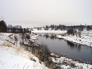
The Sit' River (Сить) is a tributary of the Rybinsk Reservoir (nominally, of the Mologa River). The river flows for 159 kilometres (99 mi) through Sonkovsky District of Tver Oblast and Nekouzsky and Breytovsky Districts of Yaroslavl Oblasts of Russia before entering the Rybinsk Reservoir near the large village of Breitovo. Its average width varies from 40 to 50 metres (130 to 160 ft). [1] The river mouth is about 1,500 metres (4,900 ft) wide. The drainage basin occupies some 1,900 square kilometres (730 sq mi). [1] The river is 159 kilometres (99 mi) long. [2]

Rybinsk Reservoir reservoir

Rybinsk Reservoir, informally called the Rybinsk Sea, is a water reservoir on the Volga River and its tributaries Sheksna and Mologa, formed by Rybinsk Hydroelectric Station dam, located in the Tver, Vologda, and Yaroslavl Oblasts. At the time of its construction, it was the largest man-made body of water on Earth. It is the northernmost point of the Volga. The Volga-Baltic Waterway starts from there. The principal ports are Cherepovets in Vologda Oblast and Vesyegonsk in Tver Oblast.

Mologa River river in Russia

The Mologa is a river in Maksatikhinsky, Bezhetsky, Lesnoy, and Sandovsky Districts of Tver Oblast, Pestovsky District in Novgorod Oblast, and Ustyuzhensky and Cherepovetsky Districts in Vologda Oblast Russia. It is a left tributary of the Volga River. The lower course of the Mologa has been turned into the Rybinsk Reservoir. It is 456 kilometres (283 mi) long, and the area of its basin 29,700 square kilometres (11,500 sq mi). The principal tributaries of the Mologa are the Osen (right), the Volchina (left), the Kobozha (left), the Chagodoshcha (left) and the Sit.

Sonkovsky District District in Tver Oblast, Russia

Sonkovsky District is an administrative and municipal district (raion), one of the thirty-six in Tver Oblast, Russia. It is located in the east of the oblast and borders with Krasnokholmsky District in the north, Nekouzsky District of Yaroslavl Oblast in the east, Kesovogorsky District in the south, and with Bezhetsky District in the west. The area of the district is 970 square kilometers (370 sq mi). Its administrative center is the urban locality of Sonkovo. Population: 8,553 ; 10,523 (2002 Census); 13,570 (1989 Census). The population of Sonkovo accounts for 48.7% of the district's total population.

The river gives its name to the bloody Battle of the Sit River (1238). In the Middle Ages the valley of the Sit River belonged to a branch of the princely House of Yaroslavl. The princes of the Sit', or Sitsky, joined the service of the Grand Dukes of Muscovy in the 15th century. The family survived into the 17th century and was closely related by blood to the Romanovs. [3]

Battle of the Sit River battle

The Battle of the Sit River was fought in the northern part of the present-day Sonkovsky District of Tver Oblast of Russia, close to the selo of Bozhonka, on March 4, 1238 between the Mongol Hordes of Batu Khan and the Rus' under Grand Prince Yuri II of Vladimir-Suzdal during the Mongol invasion of Rus.

The source of the Sit is in the north of Sonkovsky District, close to the village of Saburovo. The river flows northeast, enters Yaroslavl Oblast, and turns south. By the selo of Voznesenskoye it turns east and eventually north. The mouth of the Sit is in the selo of Breytovo. Before the Rybinsk Reservoir was filled, the Sit was a tributary of the Mologa River.

The drainage basin of the sit includes the eastern part of Krasnokholmsky District of Tver Oblast, the eastern part of Sonkovsky District, the western part of Nekouzsky District, and some areas in Breytovsky District. The district centers Sonkovo and Breytovo lie in the drainage basin of the Sit.

Krasnokholmsky District District in Tver Oblast, Russia

Krasnokholmsky District is an administrative and municipal district (raion), one of the thirty-six in Tver Oblast, Russia. It is located in the northeast of the oblast and borders with Vesyegonsky District in the north, Breytovsky District of Yaroslavl Oblast in the northeast, Nekouzsky District, also of Yaroslavl Oblast, in the southeast, Sonkovsky District in the south, Bezhetsky District in the southwest, and with Molokovsky District in the northwest. The area of the district is 1,495 square kilometers (577 sq mi). Its administrative center is the town of Krasny Kholm. Population: 11,835 ; 14,736 (2002 Census); 18,813 (1989 Census). The population of Krasny Kholm accounts for 47.4% of the district's total population.

Sonkovo Work settlement in Tver Oblast, Russia

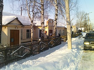
Sonkovo is an urban locality and the administrative center of Sonkovsky District of Tver Oblast, Russia. Population: 4,164 (2010 Census); 4,577 (2002 Census); 5,988 (1989 Census).

In the early 20th century the valley of the Sit River was home to the Sitskari (ru), an ethnic group of short fair-haired people speaking a Northern dialect of the Russian language. It is thought that they had a mixture of Lithuanian or some other Baltic ancestry. [4]

Northern Russian dialects

The northern Russian dialects make up one of the main groups of the Russian dialects.

Russian language East Slavic language

Russian is an East Slavic language, which is official in the Russian Federation, Belarus, Kazakhstan and Kyrgyzstan, as well as being widely used throughout Eastern Europe, the Baltic states, the Caucasus and Central Asia. It was the de facto language of the Soviet Union until its dissolution on 25 December 1991. Although, nowadays, over two decades after the breakup of the Soviet Union, Russian is used in official capacity or in public life in all the post-Soviet nation-states, as well as in Israel and Mongolia, the rise of state-specific varieties of this language tends to be strongly denied in Russia, in line with the Russian World ideology.

Lithuania republic in Northeastern Europe

Lithuania, officially the Republic of Lithuania, is a country in the Baltic region of Europe. Since its independence, Lithuania is considered to be one of the Baltic states. It is situated along the southeastern shore of the Baltic Sea, to the east of Sweden and Denmark. It is bordered by Latvia to the north, Belarus to the east and south, Poland to the south, and Kaliningrad Oblast to the southwest. Lithuania has an estimated population of 2.7 million people as of 2019, and its capital and largest city is Vilnius. Other major cities are Kaunas and Klaipėda. Lithuanians are Baltic people. The official language, Lithuanian, along with Latvian, is one of only two living languages in the Baltic branch of the Indo-European language family.

Related Research Articles

Sheksna River river in Russia

The Sheksna is a river in Belozersky, Kirillovsky, Sheksninsky, and Cherepovetsky Districts of Vologda Oblast in Russia. It is a left tributary of the Volga River. It is 139 kilometres (86 mi) long, and the area of its basin 19,000 square kilometres (7,300 sq mi). The principal tributaries of the Sheksna are the Sizma (left) and the Kovzha (right).

Nerl River (Volga) river in Russia

The Nerl River is a river in Pereslavsky District of Yaroslavl and Kalyazinsky District of Tver Oblast in Russia, a right tributary of the Volga River. The length of the river is 112 kilometres (70 mi). The area of its drainage basin is 3,270 square kilometres (1,260 sq mi). Its main tributary is the Kubr River (left).

Shosha River river in Russia

Shosha River is a river in Zubtsovsky, Staritsky, Kalininsky and in Konakovsky Districts of Tver Oblast and Lotoshinsky District of Moscow Oblast in Russia. It is a right tributary of the Volga River. The length of the Shosha River is 163 kilometres (101 mi). The area of its basin is 3,080 square kilometres (1,190 sq mi). The river flows into the Ivankovo Reservoir. The Shosha freezes up in November through early January and stays icebound until late March or early April.

Medveditsa River (Volga basin) river

Medveditsa is a river in Spirovsky, Likhoslavlsky, Rameshkovsky, Kashinsky, and Kimrsky Districts of Tver Oblast, Russia, a left tributary of the Volga River. The main tributaries are the Kushalka River (left), the Ivitsa River (right), the Drezna River (left), the Rudomosh River (left), and the Yakhroma River (right). The length of the Medveditsa is 259 kilometres (161 mi), and the area of its drainage basin is 5,570 square kilometres (2,150 sq mi).

Vazuza River river in Russia

The Vazuza is a river in Novoduginsky and Sychyovsky districts of Smolensk Oblast and Zubtsovsky District of Tver Oblast, Russia, a right tributary of the Volga River. It is 162 kilometres (101 mi) long, and its drainage basin covers 7,120 square kilometres (2,750 sq mi). The lower part of the river has been transformed into Vazuza Reservoir. The towns of Sychyovka and Zubtsov are located on the banks the Vazuza. The main tributaries of the Vazuza are the Kasnya River, the Gzhat River, and the Osuga River (left).

Suda River river in Russia

The Suda is a river in Babayevsky, Kaduysky, and Cherepovetsky Districts of Vologda Oblast in Russia. It flows into the Rybinsk Reservoir of the Volga River. It is 184 kilometres (114 mi) long, with a drainage basin of 13,500 square kilometres (5,200 sq mi) and an average discharge of 134 cubic metres per second (4,700 cu ft/s). Its main tributaries are the Shogda, the Andoga, the Kolp, the Voron and the Petukh rivers.

Sogozha River river in Russia

Sogozha is a river in Vologda and Yaroslavl Oblasts in Russia. It is 125 kilometres (78 mi) long, with a drainage basin of 2,950 square kilometres (1,140 sq mi).

Bezhetsky District District in Tver Oblast, Russia

Bezhetsky District is an administrative and municipal district (raion), one of the thirty-six in Tver Oblast, Russia. It is located in the east of the oblast and borders with Molokovsky District in the north, Krasnokholmsky District in the northwest, Sonkovsky and Kesovogorsky Districts in the east, Kashinsky District in the southeast, Rameshkovsky District in the south, and with Maksatikhinsky District in the west. The area of the district is 2,810 square kilometers (1,080 sq mi). Its administrative center is the town of Bezhetsk. Population: 36,701 ; 14,277 (2002 Census); 18,786 (1989 Census). The population of Bezhetsk accounts for 66.8% of the district's total population.

Vesyegonsky District District in Tver Oblast, Russia

Vesyegonsky District is an administrative and municipal district (raion), one of the thirty-six in Tver Oblast, Russia. It is located in the northeast of the oblast and borders with Cherepovetsky District of Vologda Oblast in the northeast, Breytovsky District of Yaroslavl Oblast in the southeast, Krasnokholmsky District in the south, Molokovsky District in the southwest, Sandovsky District in the west, and with Ustyuzhensky District of Vologda Oblast in the northwest. The area of the district is 2,047 square kilometers (790 sq mi). Its administrative center is the town of Vesyegonsk. Population: 13,481 ; 16,517 (2002 Census); 19,879 (1989 Census). The population of Vesyegonsk accounts for 54.4% of the district's total population.

Darwin Nature Reserve

Darwin Nature Reserve, Darvinsky Zapovednik is a nature reserve in the north of Russia, located in Cherepovetsky District of Vologda Oblast and Breytovsky District of Yaroslavl Oblast, on the shores of the Rybinsk Reservoir of the Volga River. It was established July 18, 1945 to study the effects of raising freshwater level on the environment. It was named after Charles Darwin.

Seredka or Seryodka (Серёдка) is the name of several rural localities in Russia:

Osen River river in Russia, right tributary of the Mologa

The Osen is a river in Bezhetsky District of Tver Oblast in Russia. It is a major right tributary of the Mologa River. It is 8.7 kilometres (5.4 mi) long, and the area of its basin is 3,210 square kilometres (1,240 sq mi).

Melecha River river in Tver Oblast, Russia

The Melecha is a river in Sandovsky, Molokovsky, and Bezhetsky Districts of Tver Oblast in Russia. Together with the Mogocha River, it forms the Osen, a major right tributary of the Mologa River. It is 95 kilometres (59 mi) long, and the area of its basin is 1,310 square kilometres (510 sq mi). The principal tributary is the Belaya River (left).

Mogocha River river in Tver Oblast, Russia

The Mogocha is a river in Krasnokholmsky, Molokovsky, and Bezhetsky Districts of Tver Oblast in Russia. Together with the Melecha River, it forms the Osen, a major right tributary of the Mologa River. It is 106 kilometres (66 mi) long, and the area of its basin is 1,880 square kilometres (730 sq mi). The principal tributaries of the Mogocha are the Uyvesh River (left) and the Loyka River (right).

The Korozhechna is a river in Sonkovsky Kesovogorsky, and Kashinsky Districts of Tver Oblast and in Myshkinsky and Uglichsky District of Yaroslavl Oblast in Russia. It is a left tributary of the Volga River. It is 147 kilometres (91 mi) long, and the area of its basin 1,690 square kilometres (650 sq mi).

References