Shosha River

Last updated
Shosha River

Shosha river01.jpg

Shosha River
Native nameШоша
Country Russia
Physical characteristics
River mouth Volga River
Length 163 km (101 mi) [1]
Basin features
Basin size 3,080 km2 (1,190 sq mi) [1]

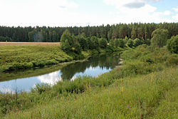
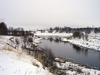
Shosha River (Russian : Шо́ша) is a river in Zubtsovsky, Staritsky, Kalininsky and in Konakovsky Districts of Tver Oblast and Lotoshinsky District of Moscow Oblast in Russia. It is a right tributary of the Volga River. The length of the Shosha River is 163 kilometres (101 mi). [1] The area of its basin is 3,080 square kilometres (1,190 sq mi). The river flows into the Ivankovo Reservoir. The Shosha freezes up in November through early January and stays icebound until late March or early April.

Russian language East Slavic language

Russian is an East Slavic language, which is official in the Russian Federation, Belarus, Kazakhstan and Kyrgyzstan, as well as being widely used throughout Eastern Europe, the Baltic states, the Caucasus and Central Asia. It was the de facto language of the Soviet Union until its dissolution on 25 December 1991. Although, nowadays, over two decades after the breakup of the Soviet Union, Russian is used in official capacity or in public life in all the post-Soviet nation-states, as well as in Israel and Mongolia, the rise of state-specific varieties of this language tends to be strongly denied in Russia, in line with the Russian World ideology.

River Natural flowing watercourse

A river is a natural flowing watercourse, usually freshwater, flowing towards an ocean, sea, lake or another river. In some cases a river flows into the ground and becomes dry at the end of its course without reaching another body of water. Small rivers can be referred to using names such as stream, creek, brook, rivulet, and rill. There are no official definitions for the generic term river as applied to geographic features, although in some countries or communities a stream is defined by its size. Many names for small rivers are specific to geographic location; examples are "run" in some parts of the United States, "burn" in Scotland and northeast England, and "beck" in northern England. Sometimes a river is defined as being larger than a creek, but not always: the language is vague.

Zubtsovsky District District in Tver Oblast, Russia

Zubtsovsky District is an administrative and municipal district (raion), one of the thirty-six in Tver Oblast, Russia. It is located in the south of the oblast and borders with Staritsky District in the north, Lotoshinsky District of Moscow Oblast in the northeast, Shakhovskoy District, also of Moscow Oblast, in the east, Gagarinsky District of Smolensk Oblast in the south, Sychyovsky District, also of Smolensk Oblast, in the southwest, and with Rzhevsky District in the west. The area of the district is 2,166.5 square kilometers (836.5 sq mi). Its administrative center is the town of Zubtsov. Population: 17,216 ; 19,398 (2002 Census); 21,950 (1989 Census). The population of Zubtsov accounts for 40.2% of the district's total population.

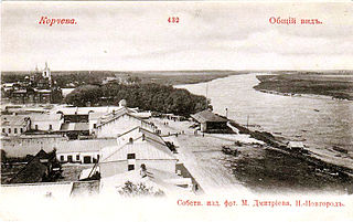
The source of the Shosha is in Zubtsovsky District of Tver Oblast, northwest of the selo of Knyazhyi Gory. It flows north, turns northeast, enters Staritsky District and turns north. At the village of Sidorovo the Shosha turns east and crosses two tiny bits of Moscow Oblast, further downstream crossing to Kalininsky District of Tver Oblast. Downstream of the village of Novinki the Shosha enters the Ivankovo Reservoir, where it accepts two of its major tributaries, the Lama (right) and the Inyukha (left). The urban-type settlements of Kozlovo and Novozavidovsky are located at the right bank of the reservoir. The Ivankovo Reservoir is crossed by the dam of the Moscow – Saint Petersburg Railway, and downstream of the dam the Volga enters from the left, at the former location of the mouth of the Shosha before the reservoir was filled in 1937.

Lama River river in Russia

Lama River is a river in the Moscow and Tver Oblasts in Russia, a tributary of the Shosha River. The river is 139 kilometres (86 mi) long. The area of its drainage basin is 2,330 square kilometres (900 sq mi). The Lama River freezes up in November and stays under the ice until late March or early April. Historically, the river was a part of the important waterway from the Volga River to the Moskva River. The city of Volokolamsk that has been standing on the Lama River since the 12th century was previously known as Volok Lamsky after the process of a watercraft portage.

Urban-type settlement is an official designation for a semi-urban settlement, used in several Eastern European countries. The term was historically used in Bulgaria, Poland, and the Soviet Union, and remains in use today in 10 of the post-Soviet states.

Kozlovo, Konakovsky District, Tver Oblast Work settlement in Tver Oblast, Russia

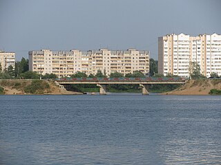
Kozlovo is an urban locality in Konakovsky District of Tver Oblast, Russia, located close the right bank of the Shosha River. Population: 3,884 (2010 Census); 4,388 (2002 Census); 4,368 (1989 Census).

The middle course of the Shosha, upstream of Kozlovo, is located in Zavidovo nature reserve, a closed area which is only accessible to high-level state employees.

Zavidovo human settlement in Russia

Zavidovo is a village (selo) in Konakovsky District of Tver Oblast, Russia. It is used as an official residence place for the President of Russia.

The drainage basin of the Shosha includes the whole Lotoshinsky District, the southwest of Konakovsky and Kalininsky District, the southeast of Staritsky District, the east of Zubtsovsky District, as well as the northern parts of Volokolamsky and Shakhovskoy Districts of Moscow Oblast, and minor areas in Klinsky and Istrinsky Districts, also in Moscow Oblast. The town of Volokolamsk and the urban-type settlements of Shakhovskaya, Lotoshino, Izoplit, Kozlovo, and Novozavidovsky lie in the drainage basin of the Shosha.

Volokolamsky District District in Moscow Oblast, Russia

Volokolamsky District is an administrative and municipal district (raion), one of the thirty-six in Moscow Oblast, Russia. It is located in the west of the oblast and borders with Mozhaysky District in the south, Shakhovskoy District in the west, Lotoshinsky District in the northwest, Klinsky District in the northeast, and with Istrinsky and Ruzsky Districts in the east. The area of the district is 1,683.51 square kilometers (650.01 sq mi). Its administrative center is the town of Volokolamsk. Population: 53,244 ; 49,032 (2002 Census); 37,863 (1989 Census). The population of Volokolamsk accounts for 44.0% of the district's total population.

Shakhovskoy District District in Moscow Oblast, Russia

Shakhovskoy District is an administrative and municipal district (raion), one of the thirty-six in Moscow Oblast, Russia. It is located in the west of the oblast. The area of the district is 1,218.88 square kilometers (470.61 sq mi). Its administrative center is the urban locality of Shakhovskaya. Population: 25,372 ; 23,061 (2002 Census); 23,783 (1989 Census). The population of Shakhovskaya accounts for 42.3% of the district's total population.

Klinsky District District in Moscow Oblast, Russia

Klinsky District is an administrative and municipal district (raion), one of the thirty-six in Moscow Oblast, Russia. It is located in the northwest of the oblast and borders with Tver Oblast in the north, Lotoshinsky District in the northwest, Volokolamsky District in the west, Istrinsky District in the south, Solnechnogorsky District in the southeast, and with Dmitrovsky District in the east. The area of the district is 2,019.62 square kilometers (779.78 sq mi). Its administrative center is the town of Klin. Population: 127,779 (2010 Census); 127,938 ; 48,658 (1989 Census). The population of Klin accounts for 63.1% of the district's total population.

Related Research Articles

Mologa River river in Russia

The Mologa is a river in Maksatikhinsky, Bezhetsky, Lesnoy, and Sandovsky Districts of Tver Oblast, Pestovsky District in Novgorod Oblast, and Ustyuzhensky and Cherepovetsky Districts in Vologda Oblast Russia. It is a left tributary of the Volga River. The lower course of the Mologa has been turned into the Rybinsk Reservoir. It is 456 kilometres (283 mi) long, and the area of its basin 29,700 square kilometres (11,500 sq mi). The principal tributaries of the Mologa are the Osen (right), the Volchina (left), the Kobozha (left), the Chagodoshcha (left) and the Sit.

Tvertsa River river in Russia

The Tvertsa is a river in Vyshnevolotsky, Spirovsky, Torzhoksky, and Kalininsky Districts, as well as in the cities of Torzhok and Tver in Tver Oblast, Russia, a left tributary of the Volga River. It is 188 kilometres (117 mi) long, and the area of its basin 6,510 square kilometres (2,510 sq mi). The principal tributaries of the Tvertsa are the Tigma River (left), the Shchegrinka River (right), the Osuga River (right), the Logovyazh River (left), and the Kava River (left).

Nerl River (Volga) river in Russia

The Nerl River is a river in Pereslavsky District of Yaroslavl and Kalyazinsky District of Tver Oblast in Russia, a right tributary of the Volga River. The length of the river is 112 kilometres (70 mi). The area of its drainage basin is 3,270 square kilometres (1,260 sq mi). Its main tributary is the Kubr River (left).

Korcheva human settlement in Russia

Korcheva was a town in central Russia, on the territory of the modern Konakovsky District, Tver Oblast, on the Volga River, with a population of a few thousand people. It was first mentioned in the 1540s as a selo. Korcheva received town status in 1781 by the order of the empress Catherine II. Korcheva was the administrative center of Korchevskoy Uyezd, one of the uyezds of Tver Viceroyalty and subsequently, from 1803, of Tver Governorate. The town was prosperous until it was bypassed by the railroads in the latter half of the nineteenth century.

Konakovo Town in Tver Oblast, Russia

Konakovo is a town and the administrative center of Konakovsky District in Tver Oblast, Russia, located on the right bank of Ivankovo Reservoir. Population: 41,291 (2010 Census); 42,335 (2002 Census); 42,522 (1989 Census).

Administratively, Tver Oblast is divided into two urban-type settlements under the federal government management, five cities and towns of oblast significance, and thirty-six districts.

Ivankovo Reservoir reservoir in Russia

Ivankovo Reservoir or Ivankovskoye Reservoir, informally known as the Moscow Sea, is the uppermost reservoir on the Volga River, in Moscow and Tver Oblasts of Russia, located some 130 km north of Moscow. The dam of the reservoir is situated in the town of Dubna. The town of Konakovo is located on its southern coast. The reservoir is connected to the Moskva River by the Moscow Canal, and is the principal fresh water source for the city of Moscow. Its area is 327 km2 (126 sq mi), and the area of its drainage basin is 41,000 km2 (16,000 sq mi).

Vazuza River river in Russia

The Vazuza is a river in Novoduginsky and Sychyovsky districts of Smolensk Oblast and Zubtsovsky District of Tver Oblast, Russia, a right tributary of the Volga River. It is 162 kilometres (101 mi) long, and its drainage basin covers 7,120 square kilometres (2,750 sq mi). The lower part of the river has been transformed into Vazuza Reservoir. The towns of Sychyovka and Zubtsov are located on the banks the Vazuza. The main tributaries of the Vazuza are the Kasnya River, the Gzhat River, and the Osuga River (left).

Kalininsky District, Tver Oblast District in Tver Oblast, Russia

Kalininsky District is an administrative and municipal district (raion), one of the thirty-six in Tver Oblast, Russia. It is located in the south of the oblast and borders with Likhoslavlsky District in the north, Rameshkovsky District in the northeast, Kimrsky District in the east, Konakovsky District in the southeast, Lotoshinsky District of Moscow Oblast in the south, Staritsky District in the southwest, and with Torzhoksky District in the west. The area of the district is 4,244.7 square kilometers (1,638.9 sq mi). Its administrative center is the city of Tver. Population: 52,047 ; 54,857 (2002 Census); 58,330 (1989 Census).

Konakovsky District District in Tver Oblast, Russia

Konakovsky District is an administrative and municipal district (raion), one of the thirty-six in Tver Oblast, Russia. It is located in the southeast of the oblast and borders with Kimrsky District in the northeast, the town of Dubna, Moscow Oblast, in the east, Dmitrovsky District of Moscow Oblast in the southeast, Klinsky District of Moscow Oblast in the south, Lotoshinsky District of Moscow Oblast in the southwest, and with Kalininsky District in the northwest. The area of the district is 2,114 square kilometers (816 sq mi). Its administrative center is the town of Konakovo. Population: 87,125 ; 49,692 (2002 Census); 55,101 (1989 Census). The population of Konakovo accounts for 47.4% of the district's total population.

Rameshkovsky District District in Tver Oblast, Russia

Rameshkovsky District is an administrative and municipal district (raion), one of the thirty-six in Tver Oblast, Russia. It is located in the eastern central part of the oblast and borders with Maksatikhinsky District in the north, Bezhetsky District in the northwest, Kashinsky District in the east, Kimrsky District in the southeast, Kalininsky District in the south, and with Likhoslavlsky District in the west. The area of the district is 2,511 square kilometers (970 sq mi). Its administrative center is the urban locality of Rameshki. Population: 14,988 ; 15,600 (2002 Census); 18,029 (1989 Census). The population of Rameshki accounts for 28.8% of the district's total population.

Staritsky District District in Tver Oblast, Russia

Staritsky District is an administrative and municipal district (raion), one of the thirty-six in Tver Oblast, Russia. It is located in the central and southern parts of the oblast and borders with Kuvshinovsky District in the north, Torzhoksky District in the northeast, Kalininsky District in the east, Lotoshinsky District of Moscow Oblast in the southeast, Zubtsovsky District in the south, Rzhevsky District in the southwest, and with Selizharovsky District in the west. The area of the district is 3,005 square kilometers (1,160 sq mi). Its administrative center is the town of Staritsa. Population: 24,056 ; 25,765 (2002 Census); 28,764 (1989 Census). The population of Staritsa accounts for 35.8% of the district's total population.

Novozavidovsky Work settlement in Tver Oblast, Russia

Novozavidovsky is an urban locality in Konakovsky District of Tver Oblast, Russia, located on the right bank of the Shosha River. Population: 7,479 (2010 Census); 7,893 (2002 Census); 8,950 (1989 Census).

Radchenko (urban-type settlement) Work settlement in Tver Oblast, Russia

Radchenko is an urban locality in Konakovsky District of Tver Oblast, Russia, located on the right bank of the Volga River. Population: 1,537 (2010 Census); 2,089 (2002 Census); 2,562 (1989 Census).

Lake Volgo is a lake in Ostashkovsky, Penovsky, and Selizharovsky Districts of Tver Oblast, Russia. The Volga River flows through the lake in its upper course. The area of the lake is 61 square kilometres (24 sq mi), and the area of its drainage basin is 3,500 square kilometres (1,400 sq mi). The urban-type settlement of Peno is located on the western bank of the lake.

Osuga River (Vazuza) river in Russia

The Osuga River is a river in Oleninsky, Rzhevsky, and Zubtsovsky Districts of Tver Oblast and in Sychyovsky District of Smolensk Oblast of Russia, a left tributary of the Vazuza River in the basin of the Volga River. The Osuga is 100 kilometres (62 mi) long, and the area of its drainage basin is 1,290 square kilometres (500 sq mi).

References

  1. 1 2 3 Shosha River in the State Water Register of Russia (Russian)

Coordinates: 56°32′56″N36°14′48″E / 56.5489°N 36.2467°E / 56.5489; 36.2467

Geographic coordinate system Coordinate system

A geographic coordinate system is a coordinate system that enables every location on Earth to be specified by a set of numbers, letters or symbols. The coordinates are often chosen such that one of the numbers represents a vertical position and two or three of the numbers represent a horizontal position; alternatively, a geographic position may be expressed in a combined three-dimensional Cartesian vector. A common choice of coordinates is latitude, longitude and elevation. To specify a location on a plane requires a map projection.