Related Research Articles

Sawtooth National Forest is a National Forest that covers 2,110,408 acres in the U.S. states of Idaho and Utah. Managed by the U.S. Forest Service in the U.S. Department of Agriculture, it was originally named the Sawtooth Forest Reserve in a proclamation issued by President Theodore Roosevelt on May 29, 1905. On August 22, 1972 a portion of the forest was designated as the Sawtooth National Recreation Area (SNRA), which includes the Sawtooth, Cecil D. Andrus–White Clouds, and Hemingway–Boulders wilderness areas. The forest is managed as four units: the SNRA and the Fairfield, Ketchum, and Minidoka Ranger Districts.

The Sawtooth National Recreation Area (SNRA) is a national recreation area in central Idaho, United States that is managed as part of Sawtooth National Forest. The recreation area, established on August 22, 1972, is managed by the U.S. Forest Service, and includes the Sawtooth, Hemingway–Boulders, and Cecil D. Andrus–White Clouds wilderness areas. Activities within the 730,864-acre (2,957.70 km2) recreation area include hiking, backpacking, White water rafting, camping, rock climbing, kayaking, mountain biking, fishing, and hunting.

The Sawtooth Range is a mountain range of the Rocky Mountains in central Idaho, United States, reaching a maximum elevation of 10,751 feet (3,277 m) at the summit of Thompson Peak. It encompasses an area of 678 square miles (1,756 km2) spanning parts of Custer, Boise, Blaine, and Elmore counties, and is bordered to the east by the Sawtooth Valley. Much of the mountain range is within the Sawtooth Wilderness, part of the Sawtooth National Recreation Area and Sawtooth National Forest.

The White Cloud Mountains are part of the Rocky Mountains of the western United States, located in central Idaho, southeast of Stanley in Custer County. The range is located within the Sawtooth National Recreation Area (SNRA) and partially within the Cecil D. Andrus–White Clouds Wilderness.
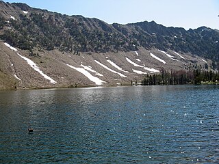
Bear Lake is an alpine lake in Custer County, Idaho, United States, located in the White Cloud Mountains in the Sawtooth National Recreation Area. The lake is accessed from Sawtooth National Forest trail 671 along Warm Springs Creek.

Crater Lake is an alpine lake in Custer County, Idaho, United States, located in the White Cloud Mountains in the Sawtooth National Recreation Area. The lake is accessed from an old dirt road along Livingston Creek.

Fourth of July Lake is an alpine lake in Custer County, Idaho, United States, located in the White Cloud Mountains in the Sawtooth National Recreation Area. The lake is accessed from Sawtooth National Forest trail 109.
Washington Lake is an alpine lake in Custer County, Idaho, United States, located in the White Cloud Mountains in the Sawtooth National Recreation Area. The lake is accessed from Sawtooth National Forest trails 109 and 203.
Lonesome Lake is an alpine lake in Custer County, Idaho, United States, located in the White Cloud Mountains in the Sawtooth National Recreation Area. The lake is accessed from Sawtooth National Forest trail 683.
Hoodoo Lake is an alpine lake in Custer County, Idaho, United States, located in the White Cloud Mountains in the Sawtooth National Recreation Area. No trails lead to the lake, but it can be accessed from Sawtooth National Forest road 666.
The Big Boulder Lakes are a chain of thirteen small alpine and glacial Paternoster lakes in Custer County, Idaho, United States, located in the White Cloud Mountains in the Sawtooth National Recreation Area. The lakes are located in the upper portion of the Big Boulder Creek watershed east of D. O. Lee Peak. In addition to the lakes listed, the Big Boulder Lakes include the four small lakes that make up The Kettles. Sawtooth National Forest trail 601 along leads to the Big Boulder Lakes.
The Kettles are a chain of four small alpine glacial lakes in Custer County, Idaho, United States, located in the White Cloud Mountains in the Sawtooth National Recreation Area. The lakes are located in the upper portion of the Big Boulder Creek watershed east of D. O. Lee Peak in the uppermost portion of the Big Boulder Lakes Basin. Sawtooth National Forest trail 601 along leads to the Big Boulder Lakes.

The Four Lakes are a chain of four small glacial Paternoster lakes in Custer County, Idaho, United States, located in the White Cloud Mountains in the Sawtooth National Recreation Area. The lakes are located in the upper portion of the Little Boulder Creek watershed upstream of Quiet Lake and east of Patterson Peak. No trails lead to the Four Lakes Basin.
The Boulder Chain Lakes are a chain of thirteen alpine and glacial Paternoster lakes in Custer County, Idaho, United States, located in the White Cloud Mountains in the Sawtooth National Recreation Area. The lakes are located in the upper portion of the Little Boulder Creek watershed north of Merriam Peak. Sawtooth National Forest trail 683 along leads to the Boulder Chain Lakes.

Chamberlain Basin is a drainage basin that contains a chain of ten alpine and glacial Paternoster lakes in Custer County, Idaho, United States, located in the White Cloud Mountains in the Sawtooth National Recreation Area. Lakes are located on the upper portion of Chamberlain Creek in the Germania Creek watershed, a tributary of the East Fork Salmon River. Castle Peak, the highest summit in the White Cloud Mountains, rises to the east and north of Chamberlain Basin. Sawtooth National Forest trail 047 crosses the basin, although most people begin their trips at the Fourth of July Creek trailhead. Individual lakes do not have official names and are listed from lowest to highest elevation.

The Born Lakes are a chain of eleven alpine and glacial Paternoster lakes in Custer County, Idaho, United States, located in the White Cloud Mountains in the Sawtooth National Recreation Area. The lakes are located on the upper portion of the Warm Springs Creek watershed, a tributary of the Salmon River. The Born Lakes surrounded by Patterson, Blackmon, and Lonesome Lake Peaks. Sawtooth National Forest trail 671 leads to the lakes. The individual lakes do have official names, and many of them have partially or nearly completely filled in with sediment.
The Champion Lakes are a chain of seven alpine and glacial Paternoster lakes in Custer County, Idaho, United States, located in the White Cloud Mountains in the Sawtooth National Recreation Area. The lakes are located on the upper portion of the Champion Creek watershed, a tributary of the Salmon River. The lakes have not been individually named, and lakes 5 and 6 are often dry. Sawtooth National Forest trail 105 leads to the lakes. In 2005 the Valley Road Forest Fire burned part of the Champion Lakes Basin.
The Casino Lakes are a chain of four alpine glacial lakes in Custer County, Idaho, United States, located in the White Cloud Mountains in the Sawtooth National Recreation Area. The lakes are located on the upper portion of the Big Casino Creek watershed, a tributary of the Salmon River. The lakes have not been individually named, and Sawtooth National Forest trail 646 leads to the lakes.
The Garland Lakes are a chain of eight small alpine glacial lakes and several former lakes in Custer County, Idaho, United States, located in the White Cloud Mountains in the Sawtooth National Recreation Area. The lakes are located on the upper portion of the Big Casino Creek watershed, a tributary of the Salmon River. The lakes have not been individually named, and Sawtooth National Forest trails 646 and 616 lead to the lakes. The Garland Lakes are south of Rough Lake and east of the Casino Lakes.

Merriam Peak, at 10,920 feet (3,330 m) is one of the peaks of the White Cloud Mountains of Custer County, Idaho. It was named for John H. Merriam who played an instrumental role in protecting the area from being mined for molybdenum. Merriam Peak is located in the middle of the range just north of Castle Peak, the highest point in the range. The peak is located in the White Clouds roadless area of Sawtooth National Recreation Area.
References
- ↑ Sawtooth National Forest. “Sawtooth National Forest” [map].1:126,720, 1”=2 miles. Twin Falls, Idaho: Sawtooth National Forest, United States Forest Service, 1998.