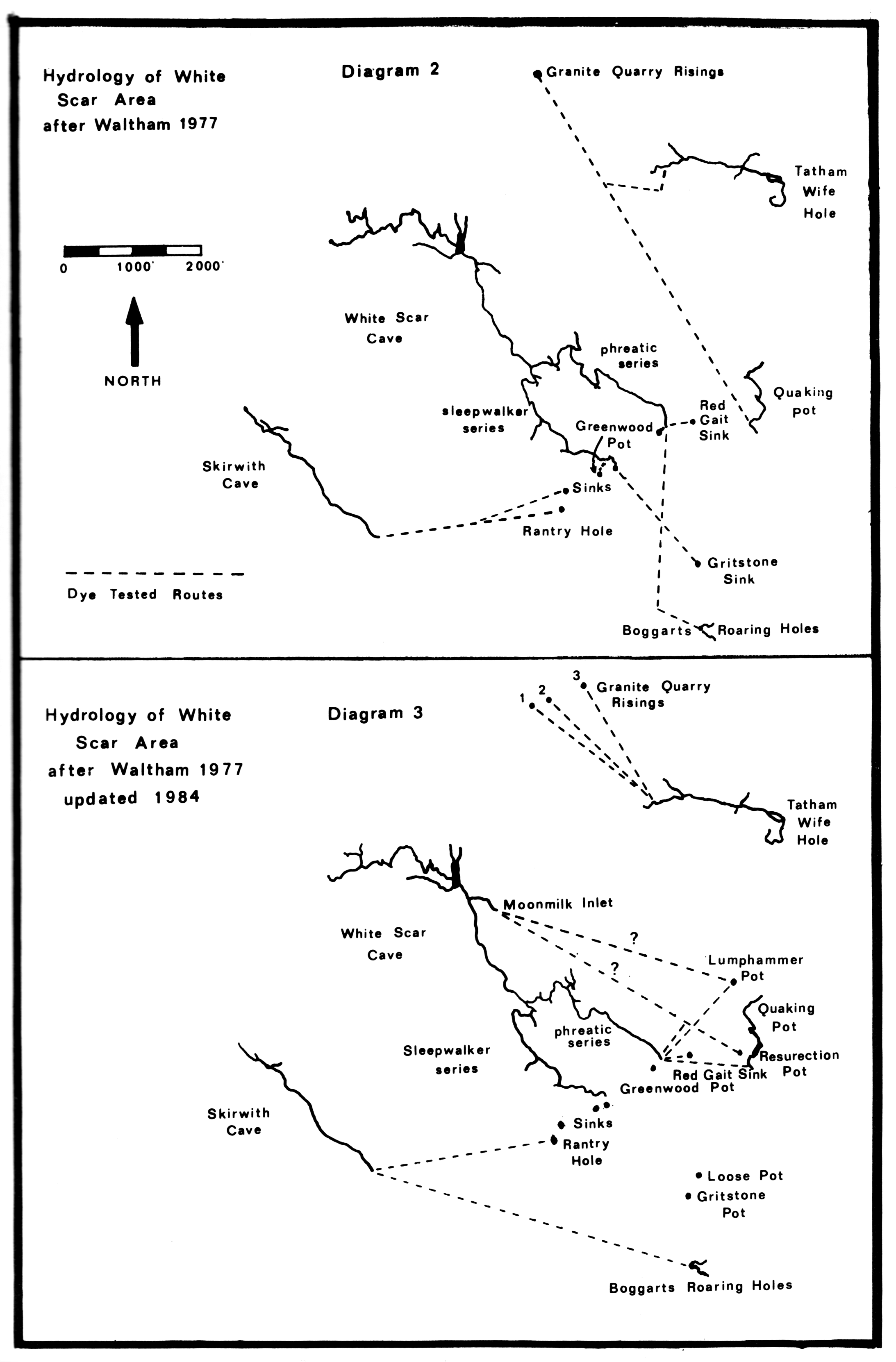
Skirwith Cave

Last updated

Skirwith Cave
Skirwith cave staircase.JPG
Remnants of a stairway in Skirwith Cave
Yorkshire Dales NP map-pre-2016.svg
Red pog.svg
Showing location of Skirwith Cave in the Yorkshire Dales
Location Ingleborough, North Yorkshire, [UK]
OS grid SD 7095 7378
Coordinates 54°09′32″N2°26′47″W / 54.158807°N 2.446307°W / 54.158807; -2.446307 [1]
Length1,000 metres (3,300 ft) [1]
Elevation275 metres (902 ft) [1]
Discovery1934 [1]
GeologyCarboniferous limestone
Entrances1
DifficultyIII [1]
Hazardswater, loose boulders [1]
AccessPermit [2]
Cave survey 1980 NCC line survey on Cavemaps

Skirwith Cave is a major resurgence solutional cave on Ingleborough in Chapel-le-Dale, North Yorkshire, England; it was a show cave between 1964 and 1974. It is no longer open to the public but is still visited by cavers. It lies within the designated Ingleborough Site of Special Scientific Interest. [3]

Contents

Description

The current entrance is through an opening in a small shakehole. This drops into a well-decorated rift passage, which was part of the former show cave. A levelled floor reaches a boulder choke which once had a flight of steps leading over it; this is now covered by a boulder collapse. The show cave terminated at a five-metre (16 ft) waterfall. Above this, a long, mainly low, wet passage reaches a sump after several hundred metres. This is the first of three short sumps separated by short sections of passage. The fourth sump has been dived for 24 metres (79 ft) to an underwater boulder choke. The cave has no inlet passages in its 1,000-metre (3,300 ft) length. [1]

Geology and hydrology

Skirwith Cave is a solutional cave formed in the lowest beds of the Visean Great Scar limestone from the Mississippian Series of the Carboniferous period, which here lies unconformably on impervious Ordovician rocks. The cave runs up dip NNE towards the valley of Crina Bottom, and drains the area around Boggarts Roaring Holes on the other side of the valley, although in times of flood it also takes water from overflow sinks in Crina Bottom itself. [4] A fragment of the continuing passage has been entered from Lower Hardgill Pot, some 400 metres (1,300 ft) away in Crina Bottom. [5] The water resurges on the basal unconformity.

History

It is thought that the cave was first entered by locals in 1934, and at least some of the upstream passages were further explored by members of the Yorkshire Ramblers' Club in 1935. [6] By 1947, the cave had been fully explored to the first sump. [7] The sumps were explored in 1965 and 1966 by members of the Happy Wanderers Cave and Pothole Club. [8]

The cave was opened as a show cave in 1964; it was always a smaller commercial operation than the nearby showcaves Ingleborough and White Scar, and more difficult of access for visitors. Blasting from the local quarry destabilized the roof and boulder piles, and the cave was closed in 1974. Little evidence remains above ground of its use as a show cave. [9]

Related Research Articles

<span class="mw-page-title-main">Ingleborough</span> Mountain in the Yorkshire Dales, England

Ingleborough is the second-highest mountain in the Yorkshire Dales, England. It is one of the Yorkshire Three Peaks, and is frequently climbed as part of the Three Peaks walk. A large part of Ingleborough is designated as a Site of Special Scientific Interest and National Nature Reserve and is the home of a new joint project, Wild Ingleborough, with aims to improve the landscape for wildlife and people.

<span class="mw-page-title-main">Gaping Gill</span> Cave in North Yorkshire, England

Gaping Gill is a natural cave in North Yorkshire, England. It is one of the unmistakable landmarks on the southern slopes of Ingleborough – a 98-metre (322 ft) deep pothole with the stream Fell Beck flowing into it. After falling through one of the largest known underground chambers in Britain, the water disappears into the bouldery floor and eventually resurges adjacent to Ingleborough Cave.

<span class="mw-page-title-main">Rowten Pot</span>

Rowten Pot is one of several entrances into the 27-kilometre (17 mi) long cave system that drains Kingsdale in North Yorkshire, England. Its entrance is a shaft some 27 metres (89 ft) long, 10 metres (33 ft) wide, and at the southern end 72 metres (236 ft) deep.

<span class="mw-page-title-main">Marble Arch Caves</span> Limestone caves in Northern Ireland

The Marble Arch Caves are a series of natural limestone caves located near the village of Florencecourt in County Fermanagh, Northern Ireland. The caves are named after the nearby Marble Arch, a natural limestone arch at the upstream end of Cladagh Glen under which the Cladagh River flows. The caves are formed from three rivers draining off the northern slopes of Cuilcagh mountain, which combine underground to form the Cladagh. On the surface, the river emerges from the largest karst resurgence in Ireland, and one of the largest in the United Kingdom. At 11.5 kilometres (7.1 mi) the Marble Arch Caves form the longest known cave system in Northern Ireland, and the karst is considered to be among the finest in the British Isles.

<span class="mw-page-title-main">White Scar Caves</span> Show cave in North Yorkshire, England

White Scar Caves is a show cave in the civil parish of Ingleton, North Yorkshire, England, under Ingleborough in the Chapel-le-Dale valley of the Yorkshire Dales National Park. It is a solutional resurgence cave formed in Carboniferous limestone, some 6 kilometres (3.7 mi) long.

<span class="mw-page-title-main">Great Douk Cave</span> Cave in North Yorkshire, England

Great Douk Cave is a shallow cave system lying beneath the limestone bench of Ingleborough in Chapel-le-Dale, North Yorkshire, England. It is popular with beginners and escorted groups, as it offers straightforward caving, and it is possible to follow the cave from where a stream emerges at a small waterfall to a second entrance close to where it sinks 600 yards (549 m) further up the hill. It lies within the Ingleborough Site of Special Scientific Interest.

<span class="mw-page-title-main">Langcliffe Pot</span> Cave system in North Yorkshire

Langcliffe Pot is a cave system on the slopes of Great Whernside in Upper Wharfedale, about 3 kilometres (1.9 mi) SSE of Kettlewell in North Yorkshire. It is part of the Black Keld Site of Special Scientific Interest where the "underground drainage system which feeds the stream resurgence at Black Keld is one of the largest and deepest in Britain, although only a small proportion of its cave passages are accessible at present." Mossdale Caverns is also part of the Black Keld SSSI. Although a considerable length of passage has been explored in Langcliffe Pot, the current end is over 170 metres (560 ft) above the resurgence, and over 4 kilometres (2.5 mi) in distance. A trip to the far end has been described as "one of the most serious undertakings in British caving".

<span class="mw-page-title-main">Short Drop Cave - Gavel Pot System</span>

Short Drop Cave and Gavel Pot are different entrances into the same cave system on Leck Fell, in Lancashire, England. The main top entrance, Short Drop Cave, is a small hole in a fenced off shakehole near the main stream sink; Gavel Pot, a window into the system, is a large fenced shakehole some 40-metre (130 ft) deep requiring tackle to descend. There are two other smaller entrances into Short Drop Cave. At its base the system links via a sump with Lost Johns' Cave, and is part of the Three Counties System, an 87 kilometres (54 mi) cave system which spans the borders of Cumbria, Lancashire, and North Yorkshire.

<span class="mw-page-title-main">Bar Pot</span>

Bar Pot is one of the entrances to the Gaping Gill cave system being located about 340 metres (370 yd) south of Gaping Gill Main Shaft, on Ingleborough in the Yorkshire Dales. It is a popular entrance into the system, being one of the easiest, driest, and having just two vertical pitches to contend with. It lies within the designated Ingleborough Site of Special Scientific Interest.

<span class="mw-page-title-main">Disappointment Pot</span>

Disappointment Pot is one of the entrances to the Gaping Gill cave system, located in a steep grassy shakehole some 120 metres (130 yd) south-east of Gaping Gill Main Shaft. Its mainly narrow stream passage descends a number of small shafts to enter the main system as a major inlet of Hensler's Master Cave. It lies within the designated Ingleborough Site of Special Scientific Interest.

<span class="mw-page-title-main">Stream Passage Pot</span>

Stream Passage Pot is one of the entrances to the Gaping Gill system being located about 320 metres (350 yd) ESE of Gaping Gill Main Shaft. It is a popular and sporting entrance into the system, featuring three well-watered big shafts. It is the highest entrance of the Gaping Gill system, so the full depth of the system, 198 metres (650 ft), is measured from its entrance. It lies within the designated Ingleborough Site of Special Scientific Interest.

<span class="mw-page-title-main">Flood Entrance Pot</span>

Flood Entrance Pot is one of the entrances to the Gaping Gill cave system located about 300 metres (330 yd) south of Gaping Gill Main Shaft. It was the first alternative entrance into the main system to be explored, and it is now a popular entrance into the system, with a fine 38-metre (125 ft) pitch landing in Gaping Gill's South-East Passage. It lies within the designated Ingleborough Site of Special Scientific Interest.

<span class="mw-page-title-main">Rat Hole, Gaping Gill</span> Cave entrance in North Yorkshire, England

Rat Hole is one of the entrances to the Gaping Gill cave system, located in the north bank of Fell Beck 30 metres (33 yd) upstream of Gaping Gill Main Shaft. A small, awkward, tube-like passage descends into a stream passage, and hence to a 100-metre (330 ft) shaft into Gaping Gill Main Chamber. The sharp and loose nature of the rock, and the quantity of water prevented full exploration for over 80 years, but the current route is described in one guide book as "a technical and exhilarating adventure". It lies within the designated Ingleborough Site of Special Scientific Interest.

<span class="mw-page-title-main">Jib Tunnel</span>

Jib Tunnel, also known as Lateral Passage is one of the entrances into the Gaping Gill cave system, located behind a large boulder in the north bank of Fell Beck adjacent to Gaping Gill Main Shaft. Although short, it leads to Lateral Shaft, a direct descent into Gaping Gill Main Chamber which is a popular caving route, and has had considerable significance in the history of the exploration of Gaping Gill. It lies within the designated Ingleborough Site of Special Scientific Interest.

<span class="mw-page-title-main">Weathercote Cave</span> Cave in North Yorkshire, England

Weathercote Cave is a natural solutional cave in Chapel-le-Dale, North Yorkshire, England. It has been renowned as a natural curiosity since the eighteenth century, and was accessible to paying visitors until 1971. The entrance is a large shaft about 20 metres (66 ft) deep, dominated by a waterfall entering at one end. It lies within the designated Ingleborough Site of Special Scientific Interest.

<span class="mw-page-title-main">Death's Head Hole</span> Cave in Lancashire, England

Death's Head Hole is a cave on Leck Fell, in Lancashire, England. Its entrance is a 64-metre (210 ft) deep shaft. It leads into Lost Johns' Cave and is part of the Three Counties System, an 87-kilometre (54 mi) cave system which spans the borders of Cumbria, Lancashire, and North Yorkshire.

Long Drop Cave is a cave on Leck Fell, in Lancashire, England. It leads into Death's Head Hole, and is part of the Three Counties System, an 87-kilometre (54 mi) cave system which spans the borders of Cumbria, Lancashire, and North Yorkshire.

<span class="mw-page-title-main">Three Counties System</span> Cave system in England

The Three Counties System is a set of inter-connected limestone solutional cave systems spanning the borders of Cumbria, Lancashire and North Yorkshire in the north of England. The possibility of connecting a number of discrete cave systems in the area to create a single super-system that spans the county borders was first proposed by Dave Brook in 1968, and it was achieved in 2011. The system is currently over 86 kilometres (53 mi) long, making it the longest in the UK and the thirtieth longest in the world, and there continues to be scope for considerably extending the system.

<span class="mw-page-title-main">Swinsto Cave</span> Cave in North Yorkshire, England

Swinsto Cave is a limestone cave in West Kingsdale, North Yorkshire, England. It leads into Kingsdale Master Cave and it is popular with cavers as it is possible to descend by abseiling down the pitches, retrieving the rope each time, and exiting through Valley Entrance of Kingsdale Master Cave at the base of the hill. It is part of a 27-kilometre (17 mi) long cave system that drains both flanks of Kingsdale.

<span class="mw-page-title-main">Long Kin East Cave - Rift Pot System</span> Cave system in North Yorkshire, England

The Long Kin East Cave - Rift Pot system is a limestone cave system on the southern flanks of Ingleborough, North Yorkshire in England lying within the designated Ingleborough Site of Special Scientific Interest. Long Kin East Cave starts as a long meandering stream passage but then plummets down a 58-metre (190 ft) deep shaft when it meets a shattered fault into which Rift Pot also descends. At the bottom, the stream flows through some low canals and sumps, to eventually emerge at Austwick Beck Head in Crummackdale.

References

  1. 1 2 3 4 5 6 7 Brook, Dave (1991). Northern Caves 2 The Three Peaks. Clapham, via Lancaster: The Dalesman Publishing Company. pp. 228–229. ISBN   1855680335.
  2. "Cave Access Information". Council of Northern Caving Clubs. Retrieved 5 January 2014.
  3. "Designated Sites View - Ingleboroough SSI". Natural England. Retrieved 2 April 2017.
  4. Waltham, A.C.; Simms, M.J.; Farrant, A.R.; Goldie, H.S. (1997). Karst and Caves of Great Britain. London: Chapman and Hall. pp. 56–57. ISBN   0412788608.
  5. Hill, Elaine; Hall, Adrian (2015). Northern Sump Index 2015. Cave Diving Group. p. 237. ISBN   978-0-901031-08-2.
  6. YRC Committee (1936). "Cave Exploration". Yorkshire Ramblers' Club Journal. 6 (22): 349–357. Retrieved 10 February 2015.
  7. Thornber, Norman (1947). Pennine Underground. Clapham, via Lancaster: The Dalesman Publishing Company. pp. 173–174.
  8. Southworth, John (1966). "Skirwith Cave". Happy Wanderers Cave and Pothole Club: 7–8.
  9. Duckeck, Jochen. "Skirwith Cave". showcaves.com. Retrieved 5 February 2016.