Skye, Victoria

Last updated

Skye
Melbourne,  Victoria
Australia Victoria metropolitan Melbourne location map.svg
Red pog.svg
Skye
Skye, Victoria
Coordinates 38°07′08″S145°12′00″E / 38.119°S 145.200°E / -38.119; 145.200
Population8,088 (2021 census) [1]
 • Density426/km2 (1,103/sq mi)
Postcode(s) 3977
Area19 km2 (7.3 sq mi)
Location
LGA(s) City of Frankston
State electorate(s) Carrum
Federal division(s) Dunkley
Suburbs around Skye:
Sandhurst Lyndhurst Lynbrook
Carrum Downs Skye Cranbourne West
Frankston North Langwarrin Cranbourne South

Skye is a suburb and semi-rural locality in Melbourne, Victoria, Australia, 38 km south-east of Melbourne's Central Business District, located within the City of Frankston local government area. Skye recorded a population of 8,088 at the 2021 census. [1]

Contents

History

Skye Post Office opened on 1 June 1889 and closed in 1895. In 1964, Lyndhurst South office (open since 1902) was renamed Skye. This office closed in 1972. [2]

There are still a couple of houses standing from the 1890s today in Skye.

Prior to 15 December 1994, Skye was a part of the City of Cranbourne (formerly the Shire of Cranbourne until April 1994). It still shares the postcode, 3977, with Cranbourne.

In January 2018, Skye's Darnley Drive and Skye Valley residential developments were devastated by the Carrum Downs Bushfire. [3]

Transport

Public Transport

Skye is serviced by one local bus service, the 760 operated by Ventura Bus Lines, which connects Skye to neighbouring suburbs as well as two railway lines - Frankston and Cranbourne

Road

To the east of Skye is the Western Port Highway which connects Skye to Dandenong, Hastings and Melbourne.

To the west is Peninsula Link which connects Skye to Mornington and Rosebud, EastLink which connects Skye to Ringwood and Dandenong, Dandenong Valley Highway which connects Skye to Frankston and Dandenong and the Nepean Highway which connects Skye to Chelsea and Portsea.

To the north is Thompsons Road which connects Skye to Carrum and Clyde North.

To the south is Cranbourne Road which connects Skye to Frankston and Cranbourne

Education

Primary Schools

The suburb has two schools, Skye Primary School and Lighthouse Christian College. Many Skye children also opt to attend larger schools in Carrum Downs such as St Joachim's Catholic Primary School, Rowellyn Park Primary School, Banyan Fields Primary School and Flinders Christian Community College

Secondary Schools

There are no secondary schools in Skye however in neighbouring suburb Carrum Downs there are two high schools, Flinders Christian Community College and Carrum Downs Secondary College. There is also two high schools in neighbouring suburb Cranbourne West, Cranbourne West Secondary College and St Peter's College. Skye children who attended St Joachim's for primary school tend to attend high school at John Paul College in Frankston

Religion

Southern Lights Christian Church [4] and Kingdom Hall of Jehovahs Witnesses serves the Skye region. Skye is part of the Seaford Parish in the Melbourne Catholic Archdiocese with the closest Catholic Church in Seaford. The closest Sikh temple is in Keysborough, the closest Hindu temple is in Carrum Downs and the closest Buddhist temple is in Springvale

Location

Skye enjoys a large area of land to the east of the suburb which is outside the main growth area and is semi-rural. It forms a green wedge between Skye and Cranbourne West, which is in the neighbouring municipality of the City of Casey. The suburb has a number of newer housing developments (many which have been developed since 2005). A full list of the developments can be seen in the section below.

Skye was ranked in 2015 as the least liveable suburb in Melbourne. Reasons cited for this included sewerage odour, a lack of public transport and a lack of shops. Nearby Sandhurst received a similarly negative ranking. [5] [6]

Sport

The suburb's Australian Rules football team, the Skye Bombers, competes in the Southern Football League. [7]

Golfers play at the Skye Public Golf Course on Ballarto and Taylors Roads, [8] at the course of the Sandhurst Club on Thompsons Road [9] or at Centenary Park Golf Course in neighbouring area, Langwarrin North

Residential Developments and Estates

Skye has multiple developments and estates, the majority of them being built from 2005 onwards. All of them are listed below.

State Politics

Since the state election on 29 November 2014, The suburb of Skye has been represented by Labor MP Sonya Kilkenny in Victoria's Legislative Assembly. Skye falls within the Electoral district of Carrum.

See also

Related Research Articles

<span class="mw-page-title-main">City of Frankston</span> Local government area in Victoria, Australia

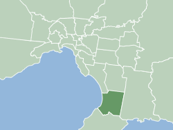
The City of Frankston is a local government area (LGA) in Victoria, Australia in the southern suburbs of Melbourne. It has an area of 130 square kilometres, and in June 2018, the City of Frankston recorded a population of 141,845.

<span class="mw-page-title-main">Endeavour Hills, Victoria</span> Suburb of Melbourne, Victoria, Australia

Endeavour Hills is a suburb in Melbourne, Victoria, Australia, 31 km (19 mi) south-east of Melbourne's Central Business District, located within the City of Casey local government area. Endeavour Hills recorded a population of 24,455 at the 2021 census.

<span class="mw-page-title-main">Clyde North, Victoria</span> Suburb of Melbourne, Victoria, Australia

Clyde North is a suburb in Melbourne, Victoria, Australia, 46 km south-east of Melbourne's Central Business District, located within the City of Casey local government area. Clyde North recorded a population of 31,681 at the 2021 census.

Cranbourne North is a suburb in Melbourne, Victoria, Australia, 39 km south-east of Melbourne's Central Business District, located within the City of Casey local government area. Cranbourne North recorded a population of 24,683 at the 2021 census.

<span class="mw-page-title-main">Carrum Downs, Victoria</span> Suburb of Melbourne, Victoria, Australia

Carrum Downs is a suburb in Melbourne, Victoria, Australia, 36 km south-east of Melbourne's Central Business District, located within the City of Frankston local government area. Carrum Downs recorded a population of 21,976 at the 2021 census.

<span class="mw-page-title-main">Frankston, Victoria</span> Town in Victoria, Australia

Frankston is a Town in Melbourne, Victoria, Australia. Located 41 km (25 mi) south-east of the Melbourne city centre, it is in the local government area of the City of Frankston and serves as its administrative and activity centres.

<span class="mw-page-title-main">Frankston North, Victoria</span> Suburb of Melbourne, Victoria, Australia

Frankston North is a suburb in Melbourne, Victoria, Australia, 38 km south-east of Melbourne's Central Business District, located within the City of Frankston local government area. Frankston North recorded a population of 5,711 at the 2021 census.

Langwarrin is a suburb in Melbourne, Victoria, Australia, 42 km (26 mi) south-east of Melbourne's Central Business District, located within the City of Frankston local government area. Langwarrin recorded a population of 23,588 at the 2021 census.

<span class="mw-page-title-main">Carrum, Victoria</span> Suburb of Melbourne, Victoria, Australia

Carrum is a suburb in Melbourne, Victoria, Australia, 33 km (21 mi) south-east of Melbourne's Central Business District, located within the City of Kingston local government area. Carrum recorded a population of 4,239 at the 2021 census.

<span class="mw-page-title-main">Frankston railway station</span> Railway station in Melbourne, Australia

Frankston railway station, in Victoria, Australia, is the terminus of the suburban electrified Frankston line and diesel-hauled services on the Stony Point line. It serves the south-eastern Melbourne suburb of Frankston, and opened on 1 August 1882.

<span class="mw-page-title-main">Patterson Lakes, Victoria</span> Suburb of Melbourne, Victoria, Australia

Patterson Lakes is a suburb in Melbourne, Victoria, Australia, 35 km (22 mi) south-east of Melbourne's Central Business District, located within the City of Kingston local government area. Patterson Lakes recorded a population of 7,793 at the 2021 census.

<span class="mw-page-title-main">Frankston Freeway</span> Freeway in Victoria

Frankston Freeway is a short freeway in southern Melbourne initially designed as a bypass of central Frankston and later incorporated a freeway-style upgrade to Wells Road in the 1970s, now acting as a link from suburban Melbourne to Frankston's eastern suburbs.

Sandhurst is an official bounded locality in Melbourne, Victoria, Australia, 37 km south-east of Melbourne's Central Business District, located within the City of Frankston local government area. Sandhurst recorded a population of 5,211 at the 2021 census.

<span class="mw-page-title-main">Electoral district of Carrum</span> State electoral district of Victoria, Australia

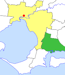
The electoral district of Carrum is an electoral district of the Victorian Legislative Assembly. It lies in the south eastern suburbs of Melbourne, covering Bangholme, Bonbeach, Carrum, Carrum Downs, Patterson Lakes, Sandhurst, Seaford and Skye.

Thompson Road is a major urban arterial road in the south-eastern suburbs of Melbourne, Victoria, Australia.

<span class="mw-page-title-main">City of Cranbourne</span> Local government area in Victoria, Australia

The City of Cranbourne was a local government area about 45 kilometres (28 mi) southeast of Melbourne, the state capital of Victoria, Australia. The city covered an area of 755 square kilometres (291.5 sq mi), and existed from 1860 until 1994. It was notable for being the last local government area to be declared a city prior to the large-scale amalgamations of 1994 – its former designation was the Shire of Cranbourne.

Karingal is a local area within the suburb of Frankston located in Melbourne, Victoria in Australia. It is in the local government area of the City of Frankston

The Longbeach Trail is a shared-use bicycle and pedestrian path running from Patterson River, Carrum, along the southwestern side of the Edithvale-Seaford Wetlands, to the Mordialloc Creek, Mordialloc. In Mordialloc, it connects to the Mordialloc Creek Trail and the Bay Trail and in the Carrum it connects to the Bay Trail and Dandenong Creek Trail.

The Melbourne Sandbelt is a region in southeastern Melbourne, Australia, known for its sandy soil. Several significant golf courses are located in the region.

References

  1. 1 2 Australian Bureau of Statistics (28 June 2022). "Skye (Vic.) (Suburbs and Localities)". 2021 Census QuickStats. Retrieved 13 July 2022. OOjs UI icon edit-ltr-progressive.svg
  2. Premier Postal History, Post Office List , retrieved 11 April 2008
  3. "300 firefighters called in to tackle Carrum Downs blaze". www.9news.com.au. 7 January 2018. Retrieved 13 March 2024.
  4. "Home". southernlights.org.au.
  5. Domain, Melbourne's 321 suburbs ranked for liveability , retrieved 11 November 2015
  6. "Melbourne's most liveable suburbs and a little secret revealed", The Age, 6 November 2015, retrieved 11 November 2015
  7. Full Point Footy, Southern Football League, archived from the original on 1 January 2009, retrieved 21 October 2008
  8. Golf Select, Skye , retrieved 11 May 2009
  9. Golf Select, Sandhurst , retrieved 11 May 2009