Sleeping Giant Wilderness Study Area is a non-motorized recreation area located on the west side of the Missouri River and Holter Lake located about 30 miles (48km) north of Helena, Montana.[1] Designated as a wilderness study area in 1981,[2] the Sleeping Giant Wilderness Study Area contains approximately 6,666 acres (2,698ha) of nearly roadless land, about half of which is forested.[2][3][4] A portion of the Lewis and Clark National Historic Trail is contained inside the study area.[2][3]
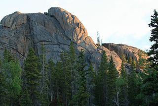
The Sleeping Giant formation, image taken from the south, looking north
Wilderness study areas (WSAs) are authorized by the Federal Land Policy and Management Act of 1976.[5] The Act directed the Bureau of Land Management (BLM) of the United States Department of the Interior to inventory and study all federally owned roadless areas for possible designation as a Wilderness Area.[5] To qualify as a wilderness study area, the land must be a roadless area of at least 5,000 acres (2,000ha) (or be of "manageable size"), generally unaffected by human development, provide opportunities for primitive or unconfined recreation, and have special ecological, geological, educational, historical, scientific and/or scenic value.[5] Until the United States Congress makes a final determination on the status of a wilderness study area, the BLM must manage the area as a wilderness.[5]
The Sleeping Giant Wilderness Study Area
Description of the Sleeping Giant area
The Sleeping Giant wilderness study area is an important habitat for mountain goats.
The Sleeping Giant region is a roughly rectangular area bounded by Interstate 15 on the west and Holter Lake on the east, the south boundary runs from the Hilger Valley to the Ming Bar , and the north boundary runs from the northern edge of the Oxbow Bend of Holter Lake to Interstate 15. The Gates of the Mountains Wilderness is nearby, beginning on the opposite side of Holter Lake.[6] There is an airplane landing strip on the Ming Bar east of the study area.[7]
The wilderness study area (WSA) contains important wildlife habitat. It is named after the "Sleeping Giant" formation (part of which is formally designated Beartooth Mountain, elevation 6,792 feet (2,070m)), a historic and noted natural landmark contained within the proposed wilderness area. [3][8] The "Sleeping Giant" outline is a widely used marketing tool by area businesses.[9] The mountains in the WSA range from 3,600 feet (1,100m) to approximately 6,800 feet (2,100m) in elevation.[2][3] About half the WSA is forested, and roughly 20 creeks and streams drain the area.[2][3] The Sleeping Giant study area is a critical mountain goat habitat in the state of Montana, and also contains significant populations of bald eagles, bighorn sheep, black bear, brook trout, cutthroat trout, elk, golden eagles, mule deer, osprey, and peregrine falcons.[3][8]
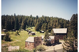
Human development within the study area is minimal. The BLM maintains several seasonally accessible dirt roads (Bear Gulch Road, Bear Ridge Road, Powerline Road, Powerline Spar, and Woodsiding Road) in the WSA, and a single year-round accessible road (Medicine Gulch Road) in the western portion of the study area. Interstate 15 and Lyons Creek Road (a county access road) border the western part of the wilderness study area. The Sleeping Giant area also includes 7 miles (11km) of horse riding and hiking trails, and 40 primitive camping sites at Holter Lake.[2][3] Several abandoned structures built by early white settlers near the lake still exist but are not maintained for use.[2][3][9]
The 3,801-acre (1,538ha)Sheep Creek Wilderness Study Area is located immediately west of and adjacent to the Sleeping Giant WSA.[10] Both WSAs are surrounded by a BLM-designated 11,609 acres (4,698ha) "Area of Critical Environmental Concern" (ACEC), and another 6,691 acres (2,708ha) of BLM land where wheeled vehicle use is managed to protect the environment.[10] This area's travel management plan was updated in 2003.[8]
History of the Sleeping Giant area
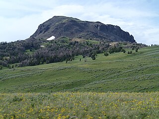
The "head" of the Sleeping Giant, image taken from the north, looking to the south
The Sleeping Giant landform was well-known to Native Americans in the United States.[11] Members of Native American tribes as far away as present-day Minnesota knew of the landmark, and told the leaders of the Lewis and Clark Expedition about it.[11] The Lewis and Clark Expedition camped below the Sleeping Giant and explored the area around it during their initial passage through the region in 1805.[11]
The Sleeping Giant region was designated a wilderness study area in 1981.[2] In late 1982, United States Secretary of the InteriorJames G. Watt removed the Sleeping Giant area from protection as a WSA, concluding that the area would never meet the definition of a wilderness area because it was too small and some mineral rights in the area were owned by private citizens or companies.[12] The Sleeping Giant region was granted WSA status again in 1985, and the WSA enlarged in 1988.[2][9] In 1991, the BLM recommended to Congress that the Sleeping Giant area be formally designated as wilderness.[2][8]
In 1991, BLM estimated that about 40 percent of the Sleeping Giant WSA contained privately owned oil and natural gas mineral rights.[13] In 1997, Lewis and Clark National Forest Supervisor Gloria Flora exercised statutory authority to ban new oil and gas development leases in the forest east of the Sleeping Giant WSA for 15 years.[14]Petroleum industry interests sued to overturn the decision, but U.S. district and appellate courts refused to do.[14] Oil and gas drilling companies asked for permission to drill exploratory wells and conduct seismic petroleum exploration in the Sleeping Giant WSA in the late 1990s, but BLM denied the request.[13][14] BLM did grant a drilling request for non-WSA land north of the Sleeping Giant WSA.[13]
In 2007, BLM proposed continuing to manage the Sleeping Giant region as a wilderness area, even though Congress had not yet acted on its 1991 recommendation to formally designate it as such.[15] The same year, the Montana Wilderness Association (MWA) began meeting with local residents in a long-term effort to build public support for formally designating the Sleeping Giant WSA a wilderness.[9] At present, the MWA is concerned that oil and gas drilling proposals in the nearby Area of Critical Concern could have a negative impact on the wilderness character of the area.[16]
The Bureau of Land Management (BLM) is an agency within the United States Department of the Interior responsible for administering U.S. federal lands. Headquartered in Washington, D.C., the BLM oversees more than 247.3 million acres (1,001,000 km2) of land, or one-eighth of the United States's total landmass.
The Blackfeet Nation, officially named the Blackfeet Tribe of the Blackfeet Indian Reservation of Montana, is a federally recognized tribe of Siksikaitsitapi people with an Indian reservation in Montana. Tribal members primarily belong to the Piegan Blackfeet band of the larger Blackfoot Confederacy that spans Canada and the United States.
The Carrizo Plain is a large enclosed grassland plain, approximately 50 miles (80 km) long and up to 15 miles (24 km) across, in southeastern San Luis Obispo County, California, United States, about 100 miles (160 km) northwest of Los Angeles. The southern portion of the Carrizo Plain is within the 246,812-acre (99,881 ha) Carrizo Plain National Monument, which also includes most of the Caliente Range. The Carrizo Plain is the largest single native grassland remaining in California. It includes Painted Rock in the Carrizo Plain Rock Art Discontiguous District, which is listed on the National Register of Historic Places. In 2012 it was further designated a National Historic Landmark due to its archeological value. The San Andreas Fault occurs along the eastern edge of the Carrizo Plain at the western base of the Temblor Range.
Bitterroot National Forest comprises 1.587 million acres (6,423 km2) in west-central Montana and eastern Idaho of the United States. It is located primarily in Ravalli County, Montana, but also has acreage in Idaho County, Idaho (29.24%), and Missoula County, Montana (0.49%).
Lewis and Clark National Forest is located in west central Montana, United States. Spanning 2,912 square miles (7,500 km2). The region was inhabited by various cultures of Native Americans for a period of at least 8,000–10,000 years. When the Lewis and Clark Expedition came to this area, different areas of the large forest territory were used by members of the Blackfeet, Sioux, Cheyenne, Flathead and Crow nations for hunting and as an area for their seasonal winter camps. The forests provided shelter from the winter.
National Conservation Lands, formally known as the National Landscape Conservation System, is a 35-million-acre (140,000 km2) collection of lands in 873 federally recognized areas considered to be the crown jewels of the American West. These lands represent 10% of the 258 million acres (1,040,000 km2) managed by the Bureau of Land Management (BLM). The BLM is the largest federal public land manager and is responsible for over 40% of all the federal public land in the nation. The other major federal public land managers include the US Forest Service (USFS), National Park Service (NPS), and the US Fish and Wildlife Service (USFWS).
The Beaver Dam Mountains Wilderness is a wilderness area located in northwestern Arizona and southwestern Utah, USA, within the arid Colorado Plateau region. The jagged mountains and gently sloping alluvial plain of the Beaver Dam Mountains straddle the border between the two states. The Wilderness contains some of the lowest elevation land in Utah, and includes a 13 miles (21 km) section of the Virgin River Gorge. The area comprises some 18,667 acres (7,554 ha), 15,000 acres (6,100 ha) of which in Arizona and approximately 3,667 acres (1,484 ha) in Utah. The area was designated Wilderness by the U.S. Congress in 1984 and is administered by the Bureau of Land Management.
A wilderness study area (WSA) contains undeveloped United States federal land retaining its primeval character and influence, without permanent improvements or human habitation, and managed to preserve its natural conditions. The Bureau of Land Management (BLM) manages wilderness study areas under the National Landscape Conservation System to protect their value as wilderness until Congress decides whether to designate them as wilderness and include in the National Wilderness Preservation System.
The Cedar Mountain Wilderness is located in northwestern Utah, United States, just south of Interstate 80. The vegetation on the upper elevations of the Cedar Mountains is dominated by junipers. The foothill and valley regions include mixed desert shrubs. Cheatgrass is prevalent over large areas burned by range fires. The remains of an aragonite mining camp can also be found in the foothills.
The National Petroleum Reserve in Alaska (NPRA) is an area of land on the Alaska North Slope owned by the United States federal government and managed by the Department of the Interior, Bureau of Land Management (BLM). It lies to the west of the Arctic National Wildlife Refuge, which, as a U.S. Fish and Wildlife Service managed National Wildlife Refuge, is also federal land.
Areas of Critical Environmental Concern (ACEC) is a conservation ecology program in the Western United States, managed by the Bureau of Land Management (BLM). The ACEC program was conceived in the 1976 Federal Lands Policy and Management Act (FLPMA), which established the first conservation ecology mandate for the BLM. The FLPMA mandate directs the BLM to protect important riparian corridors, threatened and endangered species habitats, cultural and archeological resources, as well as unique scenic landscapes that the agency assesses as in need of special management attention.
The Piper Mountain Wilderness is a federally designated wilderness area located in the White Mountains 20 miles (32 km) northeast of Big Pine, California in Inyo County, California.
Spirit Mountain Wilderness Area is a 33,518-acre (13,564 ha) wilderness area located in the Newberry Mountains in Clark County, Nevada, 10 miles (16 km) northwest of Laughlin. Spirit Mountain lies within the area. It is managed by the Bureau of Land Management and the National Park Service.
The Rock Creek Roadless Area (B032) is located northwest of Buffalo, Wyoming, in the Bighorn National Forest. It comprises roughly 34,000 acres (140 km2) of forested timberlands, mountain parks, rugged canyons, and stunning rock formations. This area represents the entire spectrum of environments found in the Bighorn National Forest and encompasses prairie land to high alpine peaks. This roadless area is the source of the north, middle, and south forks of Rock Creek, Balm of Gilead Creek, Pheasant Creek, and Ditch Creek. The area is flanked on the eastern side by the Bud Love Big Game Winter Range and the HF Bar Ranch Historic District. On the southern side the roadless area is surrounded by the Paradise Guest Ranch. The roadless area is home to elk, moose, mountain lion, pine marten, blue grouse, ruffed grouse, and raptors. The Rock Creek area is the largest area of quality elk security habitat outside of the Cloud Peak Wilderness Area and would provide an important corridor from the high country to the Bud Love Habitat Management Unit. The Rock Creek roadless area is dominated by lodgepole pine, some ponderosa, and aspen stands with low-growing juniper in the undergrowth. The area has not been opened to roads due to the ruggedness of the landscape and the high costs of implementation.
The Garnet Range, highest point Old Baldy Mountain, elevation 7,511 feet (2,289 m), is a mountain range northeast of Drummond, Montana in Powell County, Montana.
The Gravelly Range, highest peak Black Butte, el. 10,542 feet (3,213 m), is a mountain range southwest of Cameron, Montana in Madison County, Montana.
Holter Dam is a hydroelectric straight gravity dam on the Missouri River about 45 miles (72 km) northeast of Helena, Montana, in the United States. The dam, which was built between 1908 and 1918, is 1,364 feet (416 m) long and 124 feet (38 m) high. The reservoir formed by the dam, Holter Lake is 25 miles (40 km) long and has a storage capacity of 243,000 acre-feet (300,000,000 m3) of water when full. The dam is a "run-of-the-river" dam because it can generate electricity without needing to store additional water supplies behind the dam.
The Pryor Mountains Wild Horse Range is a refuge for a historically significant herd of free-roaming mustangs, the Pryor Mountain mustang, feral horses colloquially called "wild horses", located in the Pryor Mountains of Montana and Wyoming in the United States. The range has an area of 39,650 acres (160.5 km2) and was established in 1968 along the Montana–Wyoming border as the first protected refuge dedicated exclusively for mustangs. It was the second feral horse refuge in the United States. About a quarter of the refuge lies within the Bighorn Canyon National Recreation Area. A group of federal agencies, led by the Bureau of Land Management, administers the range.
Browns Canyon National Monument is a 21,586 acres (87 km2) national monument in Chaffee County, Colorado, that was designated as such by President Barack Obama under the Antiquities Act on February 19, 2015. The site will be centered along the Arkansas River between Buena Vista and Salida. Browns Canyon is the most popular destination for whitewater rafting in the country, and is also known for its fishing and hiking. The monument will provide habitat protection for bighorn sheep, peregrine falcons, elk, and golden eagles.
Hampton Buttes is a small range of mountains or hills in the U.S. state of Oregon. The range lies mostly in Crook County but extends south and west into Deschutes County in Central Oregon near the unincorporated community of Hampton. U.S. Route 20, an east–west highway, skirts the range to the south. The upper South Fork Crooked River flows north along the eastern base of the range.
This page is based on this Wikipedia article Text is available under the CC BY-SA 4.0 license; additional terms may apply. Images, videos and audio are available under their respective licenses.