A village lock-up is a historic building once used for the temporary detention of people in England and Wales, mostly where official prisons or criminal courts were beyond easy walking distance. Lockups were often used for the confinement of drunks, who were usually released the next day, or to hold people being brought before the local magistrate. The archetypal form comprises a small room with a single door and a narrow slit window, grating or holes. Most lock-ups feature a tiled or stone-built dome or spire as a roof and are built from brick, stone and/or timber.
Alfreton is a civil parish and a town in the Amber Valley district of Derbyshire, England. The parish contains 18 listed buildings that are recorded in the National Heritage List for England. Of these, one is listed at Grade II*, the middle of the three grades, and the others are at Grade II, the lowest grade. The listed buildings include two churches, a chest tomb and a sundial in a churchyard, houses and associated structures, a former village lock-up, a hotel, a milepost, a school and a war memorial.
Aston-on-Trent is a civil parish and a village in the South Derbyshire district of Derbyshire, England. The parish contains 13 listed buildings that are recorded in the National Heritage List for England. Of these, one is listed at Grade I, the highest of the three grades, one is at Grade II*, the middle grade, and the others are at Grade II, the lowest grade. The parish contains the village of Aston-on-Trent and the surrounding area. The Trent and Mersey Canal passes to the east and south of the village, and a lock and bridge on it are listed. All the other listed buildings are in the village, and consist of houses, a church and items in the churchyard, and a pump house converted into a bus shelter.
Cauldwell is a civil parish in the South Derbyshire district of Derbyshire, England. The parish contains four listed buildings that are recorded in the National Heritage List for England. Of these, one is listed at Grade II*, the middle of the three grades, and the others are at Grade II, the lowest grade. The parish contains the village of Cauldwell and the surrounding area. The listed buildings consist of a church, a small country house, and two farmhouses.
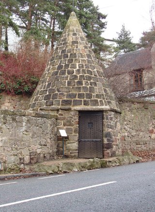
Curbar is a civil parish in the Derbyshire Dales district of Derbyshire, England. The parish contains nine listed buildings that are recorded in the National Heritage List for England. All the listed buildings are designated at Grade II, the lowest of the three grades, which is applied to "buildings of national importance and special interest". The parish contains the village of Curbar and the surrounding area. The listed buildings consist of houses, cottages and associated structures, a public house, a lock-up, a group of water troughs and millstones, a weir on the River Derwent, and a chapel.
Ilkeston is a town in the Borough of Erewash in Derbyshire, England. The town and surrounding area contain 29 listed buildings that are recorded in the National Heritage List for England. Of these, one is listed at Grade I, the highest of the three grades, three are at Grade II*, the middle grade, and the others are at Grade II, the lowest grade. The Erewash Canal passes through the area, and the listed buildings associated with it are two bridges and two locks. The other listed buildings include churches and a chapel, a church tower, houses, a museum, the town hall, two factories, a drinking fountain, a brick kiln, a library, cemetery buildings, two cinemas, a school, a railway viaduct, and two war memorials.
Ironville is a civil parish in the Amber Valley district of Derbyshire, England. The parish contains eleven listed buildings that are recorded in the National Heritage List for England. All the listed buildings are designated at Grade II, the lowest of the three grades, which is applied to "buildings of national importance and special interest". The parish contains the model village of Ironville and the surrounding area. The Cromford Canal, now disused, runs through the parish, and the listed buildings associated with this are two bridges and three locks. The other listed buildings consist of a former vicarage, a former doctor's house and surgery, a church with a war memorial in the churchyard, and a monument and a hall in Jessop Park.
Sandiacre is a civil parish in the Borough of Erewash in Derbyshire, England. The parish contains ten listed buildings that are recorded in the National Heritage List for England. Of these, one is listed at Grade I, the highest of the three grades, and the others are at Grade II, the lowest grade. The parish contains the village of Sandiacre and the surrounding area. The listed buildings consist of a church, a village lock-up and pound, two bridges crossing the Erewash Canal, a house, a milepost, a former lace factory and its office block, and two pairs of almshouses.
Sheldon is a civil parish in the Derbyshire Dales district of Derbyshire, England. The parish contains five listed buildings that are recorded in the National Heritage List for England. All the listed buildings are designated at Grade II, the lowest of the three grades, which is applied to "buildings of national importance and special interest". The parish contains the village of Sheldon and the surrounding countryside. The listed buildings consist of a cottage with attached outbuildings, a house, a church, and two buildings associated with a bobbin mill.
Shipley is a civil parish in the Amber Valley district of Derbyshire, England. The parish contains twelve listed buildings that are recorded in the National Heritage List for England. Of these, one is listed at Grade II*, the middle of the three grades, and the others are at Grade II, the lowest grade. The parish contains the village of Shipley and the surrounding area. The most important building in the parish was Shipley Hall, but this was demolished in 1948. A number of buildings in its grounds are listed, including a model farm, a former water tower, a house, and two lodges with their associated gateways. The Erewash Canal passes through the parish and the listed buildings associated with it are a bridge, a lock and a cottage. The other listed buildings are two road bridges to the south of Shipley Lake.
Smisby is a civil parish in the South Derbyshire district of Derbyshire, England. The parish contains nine listed buildings that are recorded in the National Heritage List for England. Of these, one is listed at Grade I, the highest of the three grades, one is at Grade II*, the middle grade, and the others are at Grade II, the lowest grade. The parish contains the village of Smisby and the surrounding countryside, and the listed buildings consist of houses, farmhouses, a church with associated structures, a village lock-up and a war memorial.
Somersal Herbert is a civil parish in the Derbyshire Dales district of Derbyshire, England. The parish contains twelve listed buildings that are recorded in the National Heritage List for England. Of these, one is listed at Grade I, the highest of the three grades, one is at Grade II*, the middle grade, and the others are at Grade II, the lowest grade. The parish contains the village of Somersal Herbert and the surrounding area. The major building in the parish is Somersal Herbert Hall, which is listed, together with associated structures. The other listed buildings are houses, a farmhouse, cottages and associated structures, a church and its lychgate, a churchyard cross and a telephone kiosk.
South Darley is a civil parish in the Derbyshire Dales district of Derbyshire, England. The parish contains nine listed buildings that are recorded in the National Heritage List for England. Of these, one is listed at Grade I, the highest of the three grades, and the others are at Grade II, the lowest grade. The parish contains the villages of Darley Bridge, Snitterton and Wensley, and the surrounding countryside. The listed buildings consist of houses and associated structures, a public house, a church, a milestone and a telephone kiosk.
South Normanton is a civil parish in the Bolsover District of Derbyshire, England. The parish contains eight listed buildings that are recorded in the National Heritage List for England. Of these, two are listed at Grade II*, the middle of the three grades, and the others are at Grade II, the lowest grade. The parish contains the village of South Normanton and the surrounding area, and the listed buildings consist of a country house and its coach house, a church, a former windmill, a former farmhouse, a school and two mileposts.
Stanton by Dale is a civil parish in the Borough of Erewash in Derbyshire, England. The parish contains ten listed buildings that are recorded in the National Heritage List for England. Of these, one is listed at Grade II*, the middle of the three grades, and the others are at Grade II, the lowest grade. The parish contains the village of Stanton by Dale and the surrounding area, and the listed buildings consist of a country house, a farmhouse, smaller houses and cottages, a row of almshouses, a church with a war memorial in the churchyard, a village cross and a village pump.
Sutton cum Duckmanton is a civil parish in the North East Derbyshire district of Derbyshire, England. The parish contains eleven listed buildings that are recorded in the National Heritage List for England. Of these, one is listed at Grade I, the highest of the three grades, one is at Grade II*, the middle grade, and the others are at Grade II, the lowest grade. The parish contains the villages of Sutton Scarsdale and Long Duckmanton and the surrounding countryside. The most important building is Sutton Scarsdale Hall, a ruined country house, which is listed together with associated structures. The other listed buildings consist of a church, houses, farmhouses and farmbuildings, and an ice house.
Swarkestone is a civil parish in the South Derbyshire district of Derbyshire, England. The parish contains 19 listed buildings that are recorded in the National Heritage List for England. Of these, one is listed at Grade I, the highest of the three grades, three are at Grade II*, the middle grade, and the others are at Grade II, the lowest grade. The parish contains the village of Swarkestone and the surrounding area. The Trent and Mersey Canal passes through the northern part of the parish, and the listed buildings associated with it are bridges, a lock, mileposts, and a former toll house with an outbuilding. The other listed buildings include houses and associated structures, farmhouses and farm buildings, a church and a cross in the churchyard, a public house and its former stable block, and former reading rooms.
Twyford and Stenson is a civil parish in the South Derbyshire district of Derbyshire, England. The parish contains twelve listed buildings that are recorded in the National Heritage List for England. Of these, one is listed at Grade I, the highest of the three grades, one is at Grade II*, the middle grade, and the others are at Grade II, the lowest grade. The parish contains the villages of Twyford and Stenson and the surrounding countryside. The Trent and Mersey Canal runs through the north of the parish, and the listed buildings associated with it are bridges, a lock and a cottage. The other listed buildings are a church, houses, cottages and associated structures, and farmhouses and farm buildings.
Weston-on-Trent is a civil parish in the South Derbyshire district of Derbyshire, England. The parish contains twelve listed buildings that are recorded in the National Heritage List for England. Of these, one is listed at Grade I, the highest of the three grades, one is at Grade II*, the middle grade, and the others are at Grade II, the lowest grade. The parish contains the village of Weston-on-Trent and the surrounding area. The Trent and Mersey Canal passes through the parish, and the listed buildings associated with it are bridges, a lock and mileposts. The other listed buildings are a church and houses.
Yeaveley is a civil parish in the Derbyshire Dales district of Derbyshire, England. The parish contains nine listed buildings that are recorded in the National Heritage List for England. Of these, one is listed at Grade I, the highest of the three grades, one is at Grade II*, the middle grade, and the others are at Grade II, the lowest grade. The parish contains the village of Yeaveley and the surrounding countryside. The oldest listed building in the parish consists of the remains of a preceptory of the Knights Hospitaller. The other listed buildings are houses and associated structures, farmhouses and farm buildings, and a church.

