Snoqualmie Mountain

Last updated
Snoqualmie Mountain
Snoqualmie Mountain.jpg
Highest point
Elevation 6,278 ft (1,914 m) [1]
Prominence 998 ft (304 m) [1]
Coordinates 47°27′31″N121°24′59″W / 47.4587235°N 121.4164833°W / 47.4587235; -121.4164833 Coordinates: 47°27′31″N121°24′59″W / 47.4587235°N 121.4164833°W / 47.4587235; -121.4164833 [2]
Naming
TranslationPeople of the moon(Coast Salish)
Pronunciation /snˈkwɑːlm/
Geography
Location King County, Washington, U.S.
Parent range Cascade Range
Topo map USGS Snoqualmie Pass
Climbing
Easiest route South ridge via Cave Ridge, class 2

Snoqualmie Mountain is the tallest peak in the immediate vicinity of Snoqualmie Pass in the North Cascade Range of Washington state, U.S. Its shape is often described as "amorphous" or "blob-like", although it does display a steep north face dropping down to the Middle Fork of the Snoqualmie River. The boundary of the Alpine Lakes Wilderness crosses the summit of Snoqualmie Mountain.

Snoqualmie Pass

Snoqualmie Pass is a mountain pass that carries Interstate 90 (I-90) through the Cascade Range in the U.S. State of Washington. The pass summit is at an elevation of 3,015 feet (919 m), on the county line between Kittitas County and King County.

Cascade Range mountain range in western North America

The Cascade Range or Cascades is a major mountain range of western North America, extending from southern British Columbia through Washington and Oregon to Northern California. It includes both non-volcanic mountains, such as the North Cascades, and the notable volcanoes known as the High Cascades. The small part of the range in British Columbia is referred to as the Canadian Cascades or, locally, as the Cascade Mountains. The latter term is also sometimes used by Washington residents to refer to the Washington section of the Cascades in addition to North Cascades, the more usual U.S. term, as in North Cascades National Park. The highest peak in the range is Mount Rainier in Washington at 14,411 feet (4,392 m).

United States federal republic in North America

The United States of America (USA), commonly known as the United States or America, is a country composed of 50 states, a federal district, five major self-governing territories, and various possessions. At 3.8 million square miles, the United States is the world's third or fourth largest country by total area and is slightly smaller than the entire continent of Europe's 3.9 million square miles. With a population of over 327 million people, the U.S. is the third most populous country. The capital is Washington, D.C., and the largest city by population is New York. Forty-eight states and the capital's federal district are contiguous in North America between Canada and Mexico. The State of Alaska is in the northwest corner of North America, bordered by Canada to the east and across the Bering Strait from Russia to the west. The State of Hawaii is an archipelago in the mid-Pacific Ocean. The U.S. territories are scattered about the Pacific Ocean and the Caribbean Sea, stretching across nine official time zones. The extremely diverse geography, climate, and wildlife of the United States make it one of the world's 17 megadiverse countries.

Contents

Routes

The south ridge, ascending from Cave Ridge between Snoqualmie Peak and Guye Peak, is a non-technical hike. To reach Cave Ridge, either ascend from just south of the Snow Lake trailhead near Alpental to the west, or ascend from the Commonwealth Basin to the east. Expect to take 4 hours to reach the summit. The first recorded ascent was by Albert H. Sylvester in 1897 or 1898. [3]

Guye Peak mountain in United States of America

Guye Peak is a mountain in Washington State, United States. Named for Francis M. Guye, who held an iron mining claim on it in the 1880s, it lies in the Alpine Lakes Wilderness area of the Cascade Range and overlooks Snoqualmie Pass from the north.

Alpental

Alpental, named after the German word for alpine valley, is both a valley in eastern King County, Washington, United States and a ski area in the valley. The valley is about 50 miles (80 km) east of Seattle, Washington and is north of Snoqualmie Pass, in the Washington Cascades. It is a popular outdoor recreation destination in both the summer and winter. The ski area is one of four areas which make up The Summit at Snoqualmie.

Albert Hale Sylvester American explorer

Albert Hale Slyvester was a pioneer surveyor, explorer, and forest supervisor in the Cascade Range of the U.S. state of Washington. He was a topographer for the United States Geological Survey (USGS) in the Snoqualmie Ranger District between 1897 and 1907. Then, from 1908 to 1931, he served the United States Forest Service as the first forest supervisor of Wenatchee National Forest. His work involved the first detailed surveying and mapping of large portions of the Cascade Range in Washington, over the course of which he gave names to over 1,000 natural features. The surveying work often required placing cairns and other survey targets on top of mountains. He made the first ascents of a number of mountains in Washington. Over the course of his career he explored areas previously unknown to non-indigenous people. One such area, which Sylvester discovered, explored, and named, is The Enchantments. In 1944, while leading a party of friends to one of his favorite parts of the mountains, Sylvester was mortally wounded when his horse panicked and lost his footing on a steep and rocky slope.

Related Research Articles

North Bend, Washington City in Washington, United States

North Bend is a city in King County, Washington, United States on the outskirts of the Seattle, Washington metropolitan area. The population was 6,739 in a 2016 census estimate.

Snoqualmie Pass, Washington CDP in Washington, United States

Snoqualmie Pass is a census-designated place (CDP) in King and Kittitas Counties, Washington, United States. The population was 311 at the 2010 census.

Mount Si mountain in United States of America

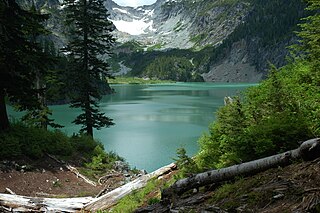
Mount Si is a mountain in the U.S. state of Washington. It lies on the western margin of the Cascade Range just above the coastal plains around Puget Sound, and towers over the nearby town of North Bend. The mountain was named after local homesteader Josiah "Uncle Si" Merritt. It was made famous in the show Twin Peaks, which was filmed in North Bend.

Mount Stuart mountain in Washington state

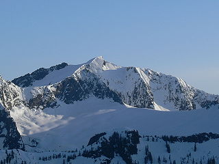
Mount Stuart is a mountain in the Cascade Range, in the U.S. state of Washington. It is the second highest non-volcanic peak in the state, after Bonanza Peak and tenth-highest overall. Mount Stuart is the highest peak in the Stuart Range, and it is located in the central part of the Washington Cascades, south of Stevens Pass and east of Snoqualmie Pass in the Alpine Lakes Wilderness.

Henry M. Jackson Wilderness

The Henry M. Jackson Wilderness is a 103,297-acre (41,803 ha) designated wilderness area in the state of Washington, United States. The area lies adjacent to the southwest corner of the Glacier Peak Wilderness, northwest of Stevens Pass on U.S. Highway 2 and northeast of the town of Skykomish, Washington. Wild Sky Wilderness is located immediately southwest of the Henry M. Jackson Wilderness. While the wilderness straddles the Cascade Mountain Range, most of it is in the westside ecotype. The wilderness lies in parts of Snoqualmie, Mount Baker, and Wenatchee national forests.

Cougar Mountain Regional Wildland Park

Cougar Mountain Regional Wildland Park is a regional park in King County, Washington, near the towns of Bellevue and Issaquah. The park was established in June 1983 to protect the central core of Cougar Mountain, the park covers 3,115 acres (12.61 km2) with 38 miles (61 km) of hiking trails and 12 miles (19 km) of equestrian trails.

Mount Tom (California) mountain in eastern California

Mount Tom is a large and prominent peak near the city of Bishop in Inyo County of eastern California. It is in the Sierra Nevada and east of the Sierra Crest. The mountain is also in the John Muir Wilderness.

Mount Monroe mountain in United States of America

Mount Monroe is a 5,372-foot-high (1,637 m) mountain peak southwest of Mount Washington in the Presidential Range of the White Mountains in New Hampshire, United States. It is named for American President James Monroe and is the fourth highest mountain on the 4000 footers list for New Hampshire. The Appalachian Trail skirts its summit, which is the next highest peak on or near the trail north of Mount Rogers in Virginia. The Lakes of the Clouds, and its AMC hut, lie nestled at the col between Mount Monroe and neighboring Mount Washington.

Goode Mountain mountain in United States of America

Goode Mountain is one of the major peaks of the North Cascades in the U.S. state of Washington. Named for topographer Richard U. Goode of the USGS, it is the highest peak located in North Cascades National Park, between the Skagit River and Lake Chelan. It is the fourth-highest non-volcanic peak in Washington, and the twelfth-highest summit overall.

Reddish Knob

Reddish Knob of Shenandoah Mountain is one of the highest points in Virginia, rising 4,397 feet (1,340 m). A narrow, paved road reaches the summit from Harrisonburg, Virginia.

Vesper Peak mountain in United States of America

Vesper Peak is a peak along the Mountain Loop Highway region of the North Cascades of Washington state. It is about 18 miles (29 km) south of Darrington and 21 miles (34 km) east of Granite Falls, in the Mount Baker-Snoqualmie National Forest. Its gentle south and east slopes contrast with a sheer north face which offers "excellent technical routes".

Boulder River Wilderness

Boulder River Wilderness is a 48,674-acre (197 km2) wilderness area within the Mount Baker-Snoqualmie National Forest in the western Cascade Range of Washington state.

Lemah Mountain mountain in United States of America

Lemah Mountain is a mountain peak in the Snoqualmie Crest, a part of the North Cascades Mountains, of the Washington state. It is located approximately 7.7 miles (12.4 km) from the city of Snoqualmie Pass. Most noted for its five distinct summits, its name, Lemah, comes from the Chinook Jargon word Lemah, in turn derived from a French word, le main, meaning "hand". Lemah Mountain, like all of the Cascade Range, is approximately 15,000 years old, formed by rocks crumpled into mountains by the Cascadia subduction zone where the Juan de Fuca and North American plates meet.

Mount Spickard mountain in United States of America

Mount Spickard is a 8,980-foot (2,740 m) mountain peak in the North Cascades, a mountain range in the U.S. state of Washington. Located just 2 miles (3.2 km) south of the Canada–US border, it is part of the Chilliwack Group, a subrange of the Skagit Range which is part of the North Cascades. It is composed mainly of gneiss and is part of two major drainage basins: that of the Skagit River and Fraser River.

Meridian Peak mountain in United States of America

Meridian Peak is a mountain summit in the Gore Range of the Rocky Mountains of North America. The 12,432-foot (3,789 m) peak is located in the Eagles Nest Wilderness, 9.0 miles (14.5 km) north by west of the Town of Vail, Colorado, United States, on the drainage divide separating White River National Forest and Eagle County from Arapaho National Forest and Summit County.

Chimney Rock (Washington) mountain in Washington, USA

Chimney Rock is a mountain located in the Alpine Lakes Wilderness of the Central Cascade Range in western Washington, United States. The mountain has two main summits, a northeast spire and a central spire, as well as a minor south peak. Situated 10 miles NNE of Snoqualmie Pass, with its craggy appearance Chimney Rock is the most distinctive peak on the crest dividing the Snoqualmie River and Yakima River drainage areas. Lemah Mountain is to the south on the crest and Summit Chief Mountain to the northeast. Overcoat Peak is off the main ridge just to the north of Chimney Rock. The mountain has three glaciers: the Overcoat Glacier on the north, the Chimney Glacier on the south and east, and an unnamed glacier on the east side of the North Peak.

Breccia Peak (Wyoming) mountain in Wyoming, United States

Breccia Peak is a mountain in the southern Absaroka Range in the Rocky Mountains. It is located in Teton County in U.S. state of Wyoming near Togwotee Pass and close to the southwest border of the Teton Wilderness within the Bridger-Teton National Forest.

Huckleberry Mountain (Washington)

Huckleberry Mountain is a 6320+ ft mountain summit located on the shared border of King County and Kittitas County in Washington state. It is within the Alpine Lakes Wilderness which is part of the Cascade Range. Huckleberry Mountain is situated on land managed by Mount Baker-Snoqualmie National Forest. Huckleberry Mountain is northeast of Snoqualmie Pass, and 0.77 mile west of Chikamin Peak, which is also its nearest higher peak. The Pacific Crest Trail traverses the south and east slope of Huckleberry Mountain, and from the trail a class 4 scramble leads to the summit. Precipitation runoff on the east side of the mountain drains into tributaries of the Yakima River, whereas the west side of the peak drains into tributaries of the Snoqualmie River.

References

  1. 1 2 "Snoqualmie Mountain, Washington". Peakbagger.com. Retrieved 2009-01-24.
  2. "Snoqualmie Mountain". Geographic Names Information System . United States Geological Survey . Retrieved 2009-01-24.
  3. Majors, Harry M. (1975). Exploring Washington. Van Winkle Publishing Co. p. 87. ISBN   978-0-918664-00-6.
United States Geological Survey scientific agency of the United States government

The United States Geological Survey is a scientific agency of the United States government. The scientists of the USGS study the landscape of the United States, its natural resources, and the natural hazards that threaten it. The organization has four major science disciplines, concerning biology, geography, geology, and hydrology. The USGS is a fact-finding research organization with no regulatory responsibility.