Pine Creek is a tributary of Mahantango Creek in Schuylkill and Dauphin counties, Pennsylvania, in the United States. It is approximately 23.7 miles (38.1 km) long. The creek flows through Foster Township, Hegins Township, Hubley Township, and Upper Mahantango Township in Schuylkill County and Lykens Township in Dauphin County. The creek's watershed has an area of 76.8 square miles (199 km2) and its tributaries include Rausch Creek and Deep Creek. Pine Creek is considered by the Pennsylvania Department of Environmental Protection to be impaired by abandoned mine drainage and resource extraction. However, it is designated as a coldwater fishery.

Mahanoy Creek is a 51.6-mile-long (83.0 km) tributary of the Susquehanna River in Northumberland and Schuylkill counties, Pennsylvania. There are at least 35 sources of acid mine drainage in the creek's watershed. Anthracite was mined in the upper part of the Mahanoy Creek watershed in the 19th and 20th centuries. Mahanoy Creek's tributaries include Schwaben Creek, Zerbe Run, Little Mahanoy Creek, Shenandoah Creek, and North Mahanoy Creek. Little Mahanoy Creek and Schwaben Creek are two streams in the watershed that are unaffected by acid mine drainage. Schwaben Creek has a higher number and diversity of fish species than the main stem.
Shenandoah Creek is a tributary of Mahanoy Creek in Schuylkill County, Pennsylvania, in the United States. It is at least 5 miles (8.0 km) long and flows through Shenandoah, West Mahanoy Township, Butler Township, and Girardville.
Lick Creek is a tributary of Shamokin Creek in Northumberland County, Pennsylvania, in the United States. It is approximately 2.7 miles (4.3 km) long and flows through Shamokin Township. The watershed of the creek has an area of 2.46 square miles (6.4 km2). The creek is not designated as impaired and its watershed is designated as a Coldwater Fishery and a Migratory Fishery. It supports some aquatic life.
Mouse Creek is a tributary of Schwaben Creek in Northumberland County, Pennsylvania, in the United States. It is approximately 5.6 miles (9.0 km) long and flows through Jordan Township, Washington Township, and Jackson Township. The watershed of the creek has an area of 7.19 square miles (18.6 km2). The creek and its tributaries are not designated as impaired waterbodies. Its watershed is at least partially in the ridge and valley physiographic province. The main land use in the upper reaches of the creek's drainage basin are forested land and agricultural land, but other land uses exist as well. A number of bridges have been constructed across the creek.

Middle Creek is a tributary of Schwaben Creek in Northumberland County, Pennsylvania, in the United States. It is approximately 3.5 miles (5.6 km) long and flows through Washington Township. The watershed of the creek has an area of 3.28 square miles (8.5 km2). The creek is designated as an impaired waterbody, with the cause of the impairment being siltation, low dissolved oxygen levels/organic enrichment, and vegetation removal and the source being agricultural activity. The creek is classified as a Trout Stocked Fishery.
Zerbe Run is a tributary of Mahanoy Creek in Northumberland County, Pennsylvania, in the United States. It is approximately 8.3 miles (13.4 km) long and flows through Coal Township, Zerbe Township, and Little Mahanoy Township. The watershed of the stream has an area of 13.1 square miles (34 km2). Part of the stream is impaired by abandoned mine drainage, but its upper reaches are not impacted by mining. Several mine drainage discharges occur within the watershed. The stream is not far from the Western Middle Anthracite Field.

Crab Run is a tributary of Mahanoy Creek in Schuylkill County, Pennsylvania, in the United States. It is approximately 2.5 miles (4.0 km) long and flows through Barry Township. The watershed of the stream has an area of 3.50 square miles (9.1 km2). Despite being listed as impaired by abandoned mine drainage, the stream is not impacted by this; no mining has been done in its watershed. However, some stream reaches in its watershed do experience agricultural impacts. The stream is not far from the Western Middle Anthracite Field. Its watershed is designated as a Coldwater Fishery and a Migratory Fishery. As of 2001, the stream contains macroinvertebrates, but no fish.
North Mahanoy Creek is a tributary of Mahanoy Creek in Schuylkill County, Pennsylvania, in the United States. It is approximately 4.4 miles (7.1 km) long and flows through Delano Township, Mahanoy Township, and Mahanoy City. The watershed of the creek has an area of 5.99 square miles (15.5 km2). The creek is designated as an impaired waterbody due to sedimentation/siltation and water/flow variation from abandoned mine drainage. The creek is relatively small, an ephemeral stream in its lower reaches, and is located within the Western Middle Anthracite Field.

Glade Run is a tributary of the West Branch Susquehanna River in Northumberland County and Lycoming County, in Pennsylvania, in the United States. It is approximately 6.5 miles (10.5 km) long and flows through Lewis Township in Northumberland County and Muncy Creek Township and Muncy in Lycoming County. The watershed of the stream has an area of 7.63 square miles (19.8 km2). The stream is not designated as an impaired waterbody. An Indian path known as the Wyoming Path was historically in the stream's vicinity. More recently, a number of bridges have been constructed over Glade Run. The stream's watershed is designated as a Warmwater Fishery and a Migratory Fishery.

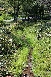
Fidlers Run is a tributary of the Susquehanna River in Northumberland County, Pennsylvania, in the United States. It is approximately 3.1 miles (5.0 km) long and flows through Jackson Township and Lower Mahanoy Township. The watershed of the stream has an area of 6.88 square miles (17.8 km2). The stream is not designated as an impaired waterbody, although a reaches of a few of its unnamed tributaries are. It is a small stream, with a width of 3 to 5 feet. Large areas of agricultural land occur along a substantial portion of its length.
Chapman Creek is a tributary of the Susquehanna River in Snyder County, Pennsylvania, in the United States. It is approximately 4.2 miles (6.8 km) long and flows through Union Township and Chapman Township. The watershed of the creek has an area of 2.81 square miles (7.3 km2). The creek has no named tributaries and is not designated as an impaired waterbody. Its drainage basin is designated as a Warmwater Fishery and a Migratory Fishery.
Dalmatia Creek is a tributary of the Susquehanna River in Northumberland County, Pennsylvania, in the United States. It is approximately 2.8 miles (4.5 km) long and flows through Lower Mahanoy Township. The watershed of the creek has an area of 2.80 square miles (7.3 km2). The creek has no named tributaries, but several unnamed ones. Both it and its tributaries are designated as impaired waterbodies due to sedimentation/siltation from crop-related agriculture and vegetation removal. Streambank erosion also occurs in the watershed. The creek is in the Ridge and Valley physiographic province.
Aline Creek is a tributary of North Branch Mahantango Creek in Snyder County, Pennsylvania, in the United States. It is approximately 2.3 miles (3.7 km) long and flows through Perry Township. The watershed of the creek has an area of 1.61 square miles (4.2 km2). The creek has no named tributaries, but does have one unnamed tributary. A reach of Aline Creek is designated as an impaired waterbody due to siltation/sedimentation from agriculture and removal of vegetation. The creek's drainage basin is designated as a Coldwater Fishery and a Migratory Fishery.
Dobson Run is a tributary of West Branch Mahantango Creek in Juniata County, Pennsylvania, in the United States. It is approximately 5.1 miles (8.2 km) long and flows through Greenwood Township and Susquehanna Township. The watershed of the stream has an area of 7.51 square miles (19.5 km2). The stream has no named tributaries, but does have several unnamed tributaries. It is one of the main streams in Susquehanna Township. The stream's drainage basin is designated as a Coldwater Fishery and a Migratory Fishery.
Leiningers Run is a tributary of West Branch Mahantango Creek in Juniata County, Pennsylvania, in the United States. It is approximately 4.9 miles (7.9 km) long and flows through Greenwood Township and Susquehanna Township. The watershed of the stream has an area of 6.96 square miles (18.0 km2). A reach of the stream is designated as an impaired waterbody due to miscellaneous habitat alteration from habitat modifications not including hydromodification. The stream's drainage basin is designated as a Coldwater Fishery and a Migratory Fishery.
Boyers Run is a tributary of the Susquehanna River in Juniata County and Perry County, in Pennsylvania, in the United States. It is approximately 2.8 miles (4.5 km) long and flows through Susquehanna Township in Juniata County and Liverpool Township in Perry County. The watershed of the stream has an area of 1.63 square miles (4.2 km2). The stream has one unnamed tributary and is not designated as an impaired waterbody. The drainage basin of Boyers Run is designated as a Warmwater Fishery and a Migratory Fishery.
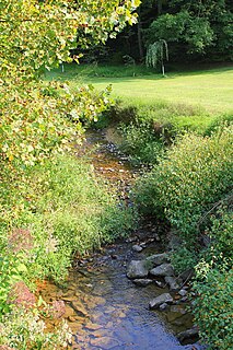
Deep Creek is a tributary of Mahantango Creek in Dauphin County, Pennsylvania, in the United States. It is approximately 5.9 miles (9.5 km) long and flows through Lykens Township and Pillow. The watershed of the creek has an area of 10.6 square miles (27 km2). It is not designated as an impaired waterbody, but is nevertheless observed to have high nitrate concentrations. Major land uses in the creek's watershed include agricultural land and forested land. The creek's watershed is classified as a Warmwater Fishery.
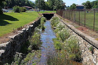
Hans Yost Creek is a tributary of Deep Creek in Schuylkill County, Pennsylvania, in the United States. It is approximately 3.4 miles (5.5 km) long and flows through Foster Township and Barry Township. The watershed of the creek has an area of 3.52 square miles (9.1 km2). The creek is designated as an impaired waterbody, with the causes being metals and pH and the probable source being abandoned mine drainage. It has no named tributaries, but two abandoned mine discharges flow into it. The creek's watershed was extensively mined in the late 1800s and early 1900s, but the only remaining active mining permits are for remining.
Little Mahantango Creek is a tributary of Mahantango Creek in Schuylkill County and Northumberland County, in Pennsylvania, in the United States. It is approximately 9.6 miles (15.4 km) long and flows through Eldred Township and Upper Mahantongo Township in Schuylkill County and Upper Mahanoy Township in Northumberland County. The watershed of the creek has an area of 15.1 square miles (39 km2). The creek has many unnamed tributaries and sub-tributaries; all of them, as well as the main stem, are impaired. The cause of impairment in Little Mahantango Creek is sedimentation/siltation and the probable source of impairment is agriculture.


