
The Karakoram is a mountain range in the Kashmir region spanning the border of Pakistan, China, and India, with the northwestern extremity of the range extending to Afghanistan and Tajikistan. Most of the Karakoram mountain range falls under the jurisdiction of Gilgit-Baltistan, which is controlled by Pakistan. Its highest peak, K2, is located in Gilgit-Baltistan, Pakistan. It begins in the Wakhan Corridor (Afghanistan) in the west, encompasses the majority of Gilgit-Baltistan, Pakistan and extends into Ladakh and Aksai Chin.

Baltistan also known as Baltiyul or Little Tibet, is a mountainous region in the Pakistani-administered territory of Gilgit-Baltistan and constitutes an northern portion of the larger Kashmir region that has been the subject of a dispute between India and Pakistan since 1947. It is located near the Karakoram and borders Gilgit to the west, China's Xinjiang to the north, Indian-administered Ladakh to the southeast, and the Indian-administered Kashmir Valley to the southwest. The average altitude of the region is over 3,350 metres (10,990 ft). Baltistan is largely administered under the Baltistan Division.
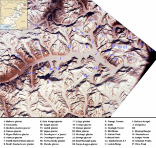
The Baltoro Glacier is a glacier located in the Shigar District of the Gilgit-Baltistan region in Pakistan. It stretches for 63 km (39 mi) in length. It is one of the longest glaciers outside the polar regions. It is home to some of the world’s highest mountains. It runs through the Karakoram mountain range, close to K2, which is the second highest peak in the world, reaching an elevation of 8,611 meters. Within a 20-kilometer radius, there are three more mountains with elevations exceeding 8,000 meters.
Snow Dome is a mountain in the Karakoram range in the Chaprot Pass region of Gilgit–Baltistan of Pakistan. It lies to the southeast of Daintar Pass and north of Mehrbani Peak which is in the Naltar Valley. Another peak, near Concordia, is also called Snow Dome, thought the one near Concordia is significantly higher at 7,150 m.
The Baltoro Muztagh is a subrange within the Karakoram mountain range. It spans across the Baltistan region of Gilgit-Baltistan, which is the northernmost political entity of Pakistan, and extends into Xinjiang, China. The crest of this range also serves as part of the border between Pakistan and China.

The Biafo Glacier Urdu: بیافو گلیشیر) is a glacier located within the Karakoram mountain range in the Hisper valley, Nagar District of Gilgit-Baltistan, Pakistan. It extends over a considerable distance, measuring 67 kilometers in length, and ranks as one of the largest glaciers in the entire Karakoram range. Flowing in a south-eastern direction from the central Karakoram crest, this glacier covers a basin area spanning 853 square kilometers, of which 628 square kilometers are characterized by permanent snow and ice. The accumulation zone alone contributes to 68% of the glacier's total area.

Trango Glacier is a glacier in the Baltoro Muztagh range of the Karakoram in Baltistan, Gilgit-Baltistan, Pakistan.

The Skardu District is a district of Pakistan-administered Gilgit-Baltistan in the disputed Kashmir region. Skardu District is bounded on the east by the Ghanche District, on the south by the Kharmang District, on the west by the Astore District, on the north-west by the Rondu District and on the north by the Shigar district. The district headquarters is the town of Skardu, which is also the division headquarters.

The Godwin-Austen Glacier is a glacier in the Karakoram range and is close to K2, the highest mountain peak in Pakistan and second highest on Earth, in Gilgit-Baltistan, Pakistan. Its confluence with the Baltoro Glacier is called Concordia and is a popular trekking destination as it provides views of four of the five eight-thousanders in the region.

Gasherbrum V is a mountain in the Gasherbrum massif, located in the Karakoram range of Gilgit–Baltistan, Pakistan.

Gilgit-Baltistan is an administrative territory of Pakistan in the northern part of the country. It was given self-governing status on August 29, 2009. Gilgit-Baltistan comprises 14 districts within three divisions. The four districts of Skardu Kharmang Shigar and Ghanche are in the Baltistan Division, four districts of Gilgit Ghizer Hunza and Nagar districts which were carved out of Gilgit District are in the Gilgit Division and the third division is Diamir, comprising Chilas and Astore. The main political centres are the towns of Gilgit and Skardu.

Baltoro Kangri is a mountain of the Karakoram mountain range in Gilgit-Baltistan, Pakistan. Baltoro Kangri is the 82nd highest mountain in the world with an elevation of 7,312 metres (23,990 ft). It lies to the south of the Gasherbrums and east of Chogolisa Peak. The huge Baltoro Glacier rises from the foot of Baltoro Kangri. On the northern side of Baltoro Kangri lies the Abruzzi Glacier.
The Abruzzi Glacier is situated to the north of the Baltoro Kangri peak in Gilgit-Baltistan, Pakistan. This glacier merges with the Baltoro Glacier, which is one of the largest glaciers outside of the polar regions. Initially, the glacier flows in a northwest direction before veering westward. The Abruzzi Glacier offers magnificent vistas of K2, the second highest peak in the world and the highest peak in Pakistan.
Mehrbani Peak is a mountain in Naltar Valley in the Gilgit District of Gilgit–Baltistan territory of Pakistan. It lies to the northwest of Naltar Peak and to the south of Snow Dome peak. The peak is also known as Khaitar Peak.
Shani Peak is a mountain in the south of Naltar Pass in the Gilgit District of Gilgit-Baltistan, Pakistan. It lies in the west of Snow Dome and in the northwest of Mehrbani Peak. To its east flows the Shani Glacier towards Naltar Valley. Peak is also known as Khaltar Peak.

Vigne Glacier is a glacier in Gilgit–Baltistan, Pakistan near Gondogoro Glacier and Baltoro Glacier. It provides access to Gondogoro (La) Pass.
The Hopper Valley, also spelled Hopar Valley, is a section of the Nagar Valley in Gilgit-Baltistan, Pakistan. It is situated approximately 10 km from Nagar Khas, the main city of the Nagar Valley. Hopper Valley is known for the Spantik and Hopper glaciers.

The Braldu River flows in the Shigar District of Gilgit Baltistan in Pakistan. The Braldu River joins the Basha Basna River, and together they form the Shigar River, which is a tributary of the Indus River.
