
Guelma Province is a province (wilaya) in eastern Algeria. Its namesake is its seat and most populous municipality: Guelma.

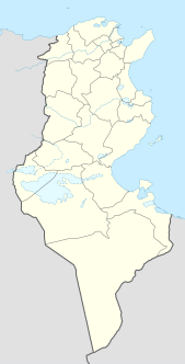
Kebili Governorate is the second largest of the 24 governorates (provinces) of Tunisia. It is situated in south-western Tunisia, bordering Algeria. It covers an area of 22,454 square kilometres (8,670 sq mi) and had a population of 156,961 at the 2014 census. The capital is Kebili.

Gharb-Chrarda-Béni Hssen was formerly one of the sixteen regions of Morocco from 1997 to 2015. It was situated in north-western Morocco, covers an area of 8,805 square kilometres (3,400 sq mi) and has a population of 1,904,112. The capital was Kenitra.

Aokas is a coastal city and district in the Béjaïa Province in northern Algeria and is located at about 25 kilometres from the province's capital city of Bgayet. The commune of Aokas was created by decree of October 2, 1869. It covered an area of 2,202 hectares and had a population of 2,245 inhabitants in 1931. Its name in berber means shark. Its average altitude is 300 meters.
Khémisset is a province in the Moroccan economic region of Rabat-Salé-Kénitra. Its population in 2004 is 521,815 This town was founded in 1924 on the site of a military outpost on the road from Rabat to Fes now a provincial capital Khemisset is also the capital of the confederation of the Berber-speaking Zemmour tribes. This is a good place to stop since there are many cafes and restaurants .The town also has a crafts cooperative where you can buy regional specialities, such as carpets and mats woven in palm fibre or wool. Every Tuesday Khemisset is the venue for one of the most important country souks in Morocco, with almost 1900 stalls The major cities and towns are:
Sidi Kacem is a province in the Moroccan economic region of Rabat-Salé-Kénitra. The capital is Sidi Kacem. Its population in 2004 was 692,239 and it recorded a population of 522,270 in the 2014 Moroccan census.

Souk El Arbaa is a town in Kénitra Province, Rabat-Salé-Kénitra, Morocco. In the 2014 Moroccan census it recorded a population of 69,265. According to the 2004 census it had a population of 43,392.
Ait Ourir is a town and municipality in Al Haouz Province, Marrakech-Tensift-Al Haouz, Morocco. At the time of the 2004 census, the commune had a total population of 20,005 people living in 3767 households.The town lies on the northern bank of the Ourika River, 29.8 kilometres (18.5 mi) by road to the northwest of Tighedouine and 33.3 kilometres (20.7 mi) east of the city centre of Marrakesh.
Bou Salem (بوسالم) is a town and commune in the Jendouba Governorate, Tunisia. As of 2004 it had a population of 20,098. by 2014 this had grown 35,192.
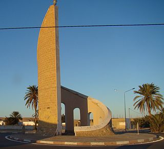
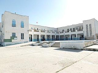
Souk Lahad is an oasis town and commune in the Kébili Governorate, Tunisia, about 15 kilometers northwest of the town of Kébili.
El Ksour القصور is a town and commune in the Kef Governorate, Tunisia. As of 2004 it had a population of 5,357. It is located 7.2 kilometres (4.5 mi) by road to the southeast of Dahmani. The Ancient Roman site Vicus Maracitanus is located to the south. The town contains some fine Berber architecture.
Sers, also Le Sers or Es Sers, is a town and commune in the Kef Governorate, Tunisia. It is located 35.5 kilometres (22.1 mi) by road southeast of El Kef. As of 2004 it had a population of 11,927. Its economic activity is mainly dominated by agriculture, including cereal production.
El Aioun Sidi Mellouk or El Aioun is a town in Taourirt Province, Oriental, Morocco. It is located along National Route 6, 50.2 kilometres (31.2 mi) northeast of Taourirt and 58.6 kilometres (36.4 mi) southwest of Oujda. According to the 2004 census it has a population of 34,767. It contains several schools including Lycee Ezzayotune, Ecole Mohamed Belkhayyat and Ecole Route de Jirada in the southeast of the town. College Sidi Makhoukh is located to the northeast, opposite the souk. It also has a hospital, Centre de Sante.
Kceibya is a small town and rural commune in Sidi Slimane Province, Rabat-Salé-Kénitra, Morocco. At the time of the 2004 census, the commune had a total population of 23,218 people living in 3295 households. It lies along the road from Sidi Yahya El Gharb to Sidi Slimane.
Oued El Makhazine is a small town and rural commune in Kénitra Province of the Rabat-Salé-Kénitra region of Morocco. At the time of the 2004 census, the commune had a total population of 8384 people living in 1704 households.
Sidi Boubker El Haj is a small town and rural commune in Kénitra Province, Rabat-Salé-Kénitra, Morocco. At the time of the 2004 census, the commune had a total population of 15,990 people living in 2286 households.
El Ganzra is a commune in the Khémisset Province of the Rabat-Salé-Kénitra administrative region of Morocco. At the time of the 2004 census, the commune had a total population of 13,404 people living in 2107 households.
Sidi El Ghandour is a commune in the Khémisset Province of the Rabat-Salé-Kénitra administrative region of Morocco. At the time of the 2004 census, the commune had a total population of 18,587 people living in 3764 households.
Ait Bouyahya El Hajjama is a commune in Khémisset Province of the Rabat-Salé-Kénitra administrative region of Morocco. At the time of the 2004 census, the commune had a total population of 5514 people living in 1066 households.


