
The South Saharan steppe and woodlands, also known as the South Sahara desert, is a deserts and xeric shrublands ecoregion of northern Africa. This band is a transitional region between the Sahara's very arid center to the north, and the wetter Sahelian Acacia savanna ecoregion to the south. In pre-modern times, the grasslands were grazed by migratory gazelles and other ungulates after the rainfalls. More recently, over-grazing by domestic livestock have degraded the territory. Despite the name of the ecoregion, there are few 'woodlands' in the area; those that exist are generally acacia and shrubs along rivers and in wadis.
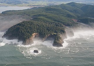
The Central Pacific coastal forests is a temperate coniferous forest ecoregion located in the Canadian province of British Columbia and the U.S. states of Oregon and Washington, as defined by the World Wildlife Fund (WWF) categorization system.

The Eastern Canadian Boreal Forests is a boreal ecoregion in Eastern Canada, defined by the One Earth ecoregion categorization system.

The Newfoundland Highland forests are a taiga ecoregion located on the island of Newfoundland in Newfoundland and Labrador, Canada. It has a total area of 4,031,999 acres.
The Transbaikal conifer forests ecoregion covers a 1,000 km by 1,000 km region of mountainous southern taiga stretching east and south from the shores of Lake Baikal in the Southern Siberia region of Russia, and including part of northern Mongolia. Historically, the area has been called "Dauria", or Transbaikal. It is in the Palearctic realm, and mostly in the boreal forests/taiga biome with a subarctic, humid climate. It covers 200,465 km2 (77,400 sq mi).
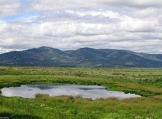
Northern Canadian Shield taiga is a taiga ecoregion located in northern Canada, stretching from Great Bear Lake in the Northwest Territories to Hudson Bay in eastern Nunavut. The region supports conifer forests to its northern edge, where the territory grades into tundra. The open forest in this transition zone is characterized by widely scattered, stunted stands of black spruce and tamarack, with some white spruce. The ecoregion lies over the northwestern extent of the Canadian Shield.

The Kamchatka-Kurile meadows and sparse forests ecoregion covers the coastal zones of the Kamchatka peninsula, northern section of the Kuril Islands, and the Commander Islands in the Russian Far East. The region noted for its sparse forests of Betula ermanii, and also for extensive tall-herb meadows. It is in the Palearctic realm, and mostly in the boreal forests/taiga biome with a Humid continental climate, cool summer climate. It covers 146,334 km2 (56,500 sq mi).

The Da Hinggan-Dzhagdy Mountains conifer forests ecoregion covers the Greater Khingan Mountains of Northeast China, and across the border north into the Russian Far East where it follows the mountain ridge for another 500 km to the east. The mountain forests exhibit a floral community called "Daurian flora", a combination of the Siberian taiga to the north and the Manchurian floral types to the south. The eastern slopes are steep and drained by many rivers, the western slopes are gentler, and there are grasslands on some slopes. The ecoregion is in the Palearctic realm, with a subarctic climate. It covers 35,199,998 km2 (13,590,795 sq mi).

The Ussuri broadleaf and mixed forests ecoregion covers a mountainous areas above the lower Amur River and Ussuri River in Primorsky Krai and Khabarovsk Krai in the Russian Far East. The ecoregion is in the Palearctic realm, with a Humid Continental climate. It covers 187,357 km2 (72,339 sq mi).

The South Sakhalin-Kurile mixed forests ecoregion is split between the southwest region of Sakhalin Island, and the southern three islands of the Kurile Islands chain in the Russian Far East. The ecoregion is in the Palearctic realm, with a Humid Continental climate. It covers 12,432 km2 (4,800 sq mi).

The Sayan Alpine meadows and tundra ecoregion is an ecoregion that covers the high areas of the Sayan Mountains above the treeline, between the Altai Mountains in the west and Lake Baikal in the east. The area is remote and protects diverse species of alpine flora and fauna. It has an area of 846,149 square kilometres (326,700 sq mi).

The Kola Peninsula tundra ecoregion is an ecoregion that covers the northeastern half of the Kola Peninsula, along the coast of the White Sea, a marginal sea of the Arctic Ocean. The maritime effects of the White Sea create a milder climate than would be expected for a region of this latitude. It is in the Palearctic realm, and the tundra biome. It has an area of 58,793 square kilometres (22,700 sq mi).
The Yamal–Gydan tundra ecoregion sprawls across the expansive Yamal Peninsula and Gydan Peninsula in the northern expanse of Russia. This unique ecoregion is characterized by its sparsely populated vegetation and wildlife, yet it holds great significance as a vital haven for migratory birds and coastal sea mammals. Embraced by the Palearctic realm and firmly entrenched in the tundra biome, it boasts an extensive area, covering approximately 412,067 square kilometers.
Opuk Nature Reserve is a protected nature reserve located on the southern coast of the Kerch Peninsula on the Black Sea. It is centered on a limestone massif rising from the kerch plains, and a salt lake. The site is a Ramsar Wetland of International Importance.

The Central Asian southern desert ecoregion is an arid but ecologically active region between the east coast of the Caspian Sea and steppes at the base of the mountains of central Asia. Most of Turkmenistan and eastern Uzbekistan is in this ecoregion. The winters are milder than in the cold desert to the north, and a large number of endemic species have adapted to living in the particular climate and soil of the region. As with sandy deserts in general, the region is notable for high numbers of endemic species of reptiles and insects.
Puget lowland forests is a temperate coniferous forest ecoregion the Pacific coast of North America, as defined by the World Wildlife Fund (WWF) categorization system.

Pacific Coastal Mountain icefields and tundra is a tundra ecoregion in Alaska, British Columbia, and Yukon, as defined by the World Wildlife Fund (WWF) categorization system.

The Northern Triangle subtropical forests ecoregion covers remote, mountainous terrain in the far north of Myanmar. Due to the regions isolation it is relatively untouched and unexplored by humans. Over 95% of the ecoregion is covered with closed evergreen forest, and importantly for conservation, these forests exist in large contiguous blocks. As of the late 1990s, 140 mammal species were known to be in the region, and new species, such the Leaf muntjac discovered in 1997, are still being found.

Northern Cordillera forests is a taiga ecoregion that extends across the northern interior of British Columbia, southern Yukon, and a small area of the Northwest Territories as defined by the World Wildlife Fund (WWF) categorization system.

The Faroe Islands boreal grasslands ecoregion covers all of the territory of the Faroe Islands, an archipelago of 18 islands in the North Atlantic, roughly equidistant between Scotland, Norway, and Iceland. The ground cover is mostly grassland and dwarf shrub heath, the remainder is bare ground or sparse vegetation. There are no forests on the islands.


