Related Research Articles
The Global 200 is the list of ecoregions identified by the World Wide Fund for Nature (WWF), the global conservation organization, as priorities for conservation. According to WWF, an ecoregion is defined as a "relatively large unit of land or water containing a characteristic set of natural communities that share a large majority of their species dynamics, and environmental conditions". For example, based on their levels of endemism, Madagascar gets multiple listings, ancient Lake Baikal gets one, and the North American Great Lakes get none.

The Leeward Islands are a group of islands situated where the northeastern Caribbean Sea meets the western Atlantic Ocean. Starting with the Virgin Islands east of Puerto Rico, they extend southeast to Guadeloupe and its dependencies. In English, the term Leeward Islands refers to the northern islands of the Lesser Antilles chain. The more southerly part of this chain, starting with Dominica, is called the Windward Islands. Dominica was originally considered a part of the Leeward Islands, but was transferred from the British Leeward Islands to the British Windward Islands in 1940.

The administrative divisions of France are concerned with the institutional and territorial organization of French territory. These territories are located in many parts of the world. There are many administrative divisions, which may have political, electoral (districts), or administrative objectives. All the inhabited territories are represented in the National Assembly, Senate and Economic and Social Council and their citizens have French citizenship and elect the President of France.

The Vanuatu rain forests are tropical and subtropical moist broadleaf forests ecoregion which includes the islands of Vanuatu, as well as the Santa Cruz Islands group of the neighboring Solomon Islands. It is part of the Australasian realm, which includes neighboring New Caledonia and the Solomon Islands, as well as Australia, New Guinea, and New Zealand.

The New Caledonia rain forests are a terrestrial ecoregion, located in New Caledonia in the South Pacific. It is a tropical moist broadleaf forest ecoregion, part of the Australasian realm.
The Caribbean bioregion is a biogeographic region that includes the islands of the Caribbean Sea and nearby Atlantic islands, which share a fauna, flora and mycobiota distinct from surrounding bioregions.

The Amazon–Orinoco–Southern Caribbean mangroves (NT1401) is an ecoregion along the coasts of Colombia, Venezuela, Guyana, Suriname, French Guiana and Brazil.

The Paramaribo swamp forests (NT0149) is an ecoregion in the coastal plain of Suriname covering a strip of land that is almost always flooded by fresh waters. It transitions into saline mangrove swamps towards the coast, and into submontane forests towards the interior.

The Tongan tropical moist forests is a tropical and subtropical moist broadleaf forests ecoregion that includes the Tonga archipelago and Niue.

The Society Islands tropical moist forests is a tropical and subtropical moist broadleaf forests ecoregion in the Society Islands of French Polynesia.
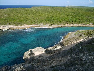
The Leeward Islands xeric scrub ecoregion covers the dry ('xeric'), non-forested areas of the Leeward Islands on the northeastern edge of the Caribbean Sea, stretching from the Virgin Islands in the west to Guadeloupe to the southeast. The non-forested areas are generally low scrub shrub, on the low elevations around the peripheries of the islands. Non-forested lower elevations in the region receive less rainfall and are typically semi-arid. A notable feature of the ecoregion is its position in the main hurricane track. The frequent damage to trees allows more pre-climax shrubs and trees to grow. There are a number of endemic species, as in common with islands.

The Windward Islands xeric scrub ecoregion covers the relatively small areas of the Windward Islands that receive low levels of precipitation. The dry areas of these islands are the low coastal areas that receive less precipitation. Because the dry scrub land is generally flat, near the coast, and not as obviously in need of conservation as the upland forests of the interior, they are more vulnerable to human settlement and development for agriculture.

The Windward Islands moist forests ecoregion covers forested, high-precipitation areas of the volcanic Windward Islands. The forested areas are mostly at higher elevations in the interior of the islands, surrounded by dry forests, dry shrubland, or mangroves on the flat coastal lowlands. Closed forest of this ecoregion cover the majority of the islands. Species diversity is very high.
References
- Abell, R., M. Thieme, C. Revenga, M. Bryer, M. Kottelat, N. Bogutskaya, B. Coad, N. Mandrak, S. Contreras-Balderas, W. Bussing, M. L. J. Stiassny, P. Skelton, G. R. Allen, P. Unmack, A. Naseka, R. Ng, N. Sindorf, J. Robertson, E. Armijo, J. Higgins, T. J. Heibel, E. Wikramanayake, D. Olson, H. L. Lopez, R. E. d. Reis, J. G. Lundberg, M. H. Sabaj Perez, and P. Petry. (2008). Freshwater ecoregions of the world: A new map of biogeographic units for freshwater biodiversity conservation. BioScience 58:403-414, .
- Spalding, Mark D., Helen E. Fox, Gerald R. Allen, Nick Davidson et al. "Marine Ecoregions of the World: A Bioregionalization of Coastal and Shelf Areas". Bioscience Vol. 57 No. 7, July/August 2007, pp. 573–583.