
Amsterdam is a town in Montgomery County, New York, United States. The population was 5,566 at the 2010 census. The town is named after Amsterdam, the capital of the Netherlands.
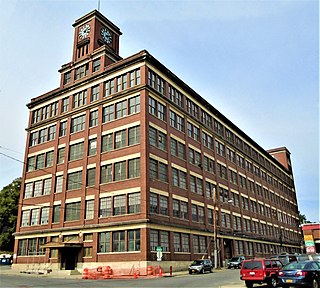
Amsterdam is a city in Montgomery County, New York, United States. As of the 2010 census, the city had a population of 18,620. The city is named after Amsterdam in the Netherlands.

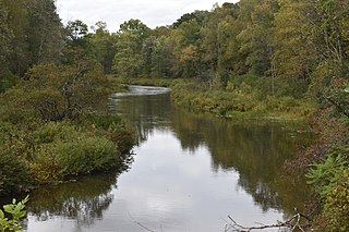
The Mohawk River is a 149-mile-long (240 km) river in the U.S. state of New York. It is the largest tributary of the Hudson River. The Mohawk flows into the Hudson in Cohoes, New York, a few miles north of the city of Albany. The river is named for the Mohawk Nation of the Iroquois Confederacy. It is a major waterway in north-central New York. The largest tributary, the Schoharie Creek, accounts for over one quarter (26.83%) of the Mohawk River's watershed. Another main tributary is the West Canada Creek, which makes up for 16.33% of the Mohawk's watershed.

The West Branch Delaware River is one of two branches that form the Delaware River. It is approximately 90 mi (144 km) long, and flows through the U.S. states of New York and Pennsylvania. It winds through a mountainous area of New York in the western Catskill Mountains for most of its course, before joining the East Branch along the northeast border of Pennsylvania with New York. Midway or so it is empounded by the Cannonsville Dam to form the Cannonsville Reservoir, both part of the New York City water supply system for delivering drinking water to the City.

Schoharie Creek is a river in New York that flows north 93 miles (150 km) from the foot of Indian Head Mountain in the Catskills through the Schoharie Valley to the Mohawk River. It is twice impounded north of Prattsville to create New York City's Schoharie Reservoir and the Blenheim-Gilboa Power Project.

Esopus Creek is a 65.4-mile-long (105.3 km) tributary of the Hudson River that drains the east-central Catskill Mountains in the U.S. state of New York. From its source at Winnisook Lake on the slopes of Slide Mountain, the Catskills' highest peak, it flows across Ulster County to the Hudson at Saugerties. Many tributaries extend its watershed into neighboring Greene County and a small portion of Delaware County. Midway along its length, it is impounded at Olive Bridge to create Ashokan Reservoir, the first of several built in the Catskills as part of New York City's water supply system. Its own flow is supplemented 13 miles (21 km) above the reservoir by the Shandaken Tunnel, which carries water from the city's Schoharie Reservoir into the creek.
New York State Route 5S (NY 5S) is a 72.92-mile-long (117.35 km) east–west state highway located in the Mohawk Valley of New York in the United States. It extends from a continuation of NY 5A at an interchange with NY 5, NY 8, NY 12, and Interstate 790 (I-790) in Utica to an interchange with NY 890 in Rotterdam. The route runs along the south side of the Mohawk River for its entire length and parallels NY 5, which runs along the north side of the Mohawk River. NY 5S intersects several primary routes including NY 28 in Mohawk, NY 30A in Fultonville, NY 30 south of Amsterdam, as well as intersecting the New York State Thruway (I-90) several times. The route is part of New York State Bicycle Route 5 west of its junction with NY 103 in Schenectady County.

The Napa River-Napa Creek Flood Protection Project is a Civil Works project of the US Army Corps of Engineers in the city of Napa, California. The Project area includes some 6 miles (10 km) of the Napa River from the Butler Bridge on State Route 29 on the south to Trancas Street on the north. This section is the upper reach of the estuary portion of the Napa River and as such is tidally influenced. The Project also includes improvements to 1 mile (1.6 km) of Napa Creek, the primary tributary to the Napa River. The project is cited as a new way of thinking about flood control due to its "living river" principles.
New York State Route 103 (NY 103) is a state highway in Schenectady County, New York, in the United States. It runs for just 0.50 miles (0.80 km) from an intersection with NY 5S in the hamlet of Rotterdam Junction to NY 5 in the town of Glenville. In between, the route crosses the Mohawk River at Erie Canal at Lock 9. When it was assigned in the early 1930s, it was the only crossing of the Mohawk River between Pattersonville and downtown Schenectady. It later became the only bridge between Amsterdam and Schenectady. Its regional importance declined following the completion of NY 890 near Schenectady in 1998. In late 2011, NY 103 was closed for three months to repair parts of the road damaged by Hurricane Irene and Tropical Storm Lee.

The Great Flats Nature Trail is a protected wetland habitat mostly located in the town of Rotterdam, New York, United States. It is situated just west of the city of Schenectady on West Campbell Road (NY 337).

Butternut Creek is a stream in the greater Syracuse, New York area and a tributary of Limestone Creek, part of the Oneida Lake watershed. The creek is about 16 miles (26 km) long.
Oaks Creek is a river that drains Canadarago Lake, which is situated in the north central region of Otsego County, New York. The creek begins by the Hamlet of Schuyler Lake and flows southeast approximately 9.32 miles (15.00 km), dropping only 105 feet (32 m) in elevation, before converging with the Susquehanna River south of the Village of Cooperstown, by the Hamlet of Index. From the source to Oaksville the creek flows along Panther Mountain. Fly Creek is a main tributary, that converges with Oaks Creek south of the Hamlet of Fly Creek.
Otsquago Creek is a river that enters the Mohawk River in Fort Plain, New York. Otsquago is a Mohawk Indian word meaning 'under the bridge,' probably referring to an early bridge of felled trees along the creek, a way of making small bridges. It is also referred to as Otsquage on old maps, which is an Indian word for 'healing waters'.

The Canajoharie Creek is a river that flows into the Mohawk River in the Village of Canajoharie in the U.S. State of New York. The name "Canajoharie" is a Mohawk language term meaning "the pot that washes itself", referring to the "Canajoharie Boiling Pot", a 20-foot (6.1 m) wide and 10-foot (3.0 m) deep pothole in the Canajoharie Creek, just south of the village of Canajoharie. Bowmans Creek is one main tributary that enters the creek east of the Hamlet of Sprout Brook. The other main tributary is Brimstone Creek which enters the creek north-northwest of the Village of Ames.

Fulmer Creek is an 11.5-mile-long (18.5 km) river that flows into the Mohawk River in Mohawk, New York. The creek derives its name from the "Fulmer" family, who bought land through the Burnetsfield patent of 1725, in which lands on the present village site were granted out.
Steele Creek begins in an unnamed swamp south of Cedarville, New York, and flows northeast before emptying into the Mohawk River in the village of Ilion. Steele Creek travels through the Ilion Gorge and alongside NY-51 for most of its length. Steele Creek derives its name from Rudolph Stahl, who built the first grist mill in Ilion along the creek.
Caroga Creek is a river in Fulton and Montgomery counties in the U.S. State of New York. It begins at East Caroga Lake and flows south passing through Rockwood Lake before converging with the Mohawk River in the Hamlet of Palatine Church.
Cayadutta Creek is a river in Fulton and Montgomery counties in the state of New York. It begins northwest of Gloversville and flows in a general southward direction before flowing into the Mohawk River in Fonda. The Indian meaning of Cayadutta is "rippling waters" or "shallow water running over stones". This stream has commercial and historical importance as the cities of Johnstown and Gloversville lie on its banks.
East Kill, a 16-mile-long (26 km) tributary of Schoharie Creek, flows across the town of Jewett, New York, United States, from its source on Stoppel Point. Ultimately its waters reach the Hudson River via the Mohawk. Since it drains into the Schoharie upstream of Schoharie Reservoir, it is part of the New York City water supply system. East Kill drains the southern slopes of the Blackhead Mountains, which include Thomas Cole Mountain, Black Dome, and Blackhead Mountain, the fourth-, third-, and fifth-highest peaks in the Catskills, respectively.

Batavia Kill is a 21-mile-long (34 km) tributary of Schoharie Creek, that flows across the towns of Windham, Ashland and Prattsville in the U.S. state of New York. Its waters reach the Hudson River via Schoharie Creek and the Mohawk River. Since it drains into the Schoharie upstream of Schoharie Reservoir, it is part of the New York City water supply system. From the source to Maplecrest, Batavia Kill drains the northern slopes of the Blackhead Mountains, which include Thomas Cole Mountain, Black Dome, and Blackhead Mountain, the fourth-, third-, and fifth-highest peaks in the Catskills, respectively.

