South Fork Coquille River

Last updated
South Fork Coquille River
Coquille river falls.jpg
The lower tier of Coquille River Falls at low water
USA Oregon location map.svg
Red pog.svg
Location of the mouth of the South Fork Coquille River in Oregon
Location
Country United States
State Oregon
Region Coos County
Cities Powers, Broadbent, Myrtle Point
Physical characteristics
Source Southern Oregon Coast Range
  locationUnnamed ridge, north of Mount Bolivar
  coordinates 42°50′24″N123°52′30″W / 42.84000°N 123.87500°W / 42.84000; -123.87500 [1]
  elevation3,501 ft (1,067 m) [2]
Mouth Coquille River
  location
Myrtle Point
  coordinates
43°04′49″N124°08′29″W / 43.08028°N 124.14139°W / 43.08028; -124.14139 Coordinates: 43°04′49″N124°08′29″W / 43.08028°N 124.14139°W / 43.08028; -124.14139 [1]
  elevation
13 ft (4.0 m) [1]
Length62.8 mi (101.1 km)
Basin size288 sq mi (750 km2) [3]
Discharge 
  location Powers [4]
  average778 cu ft/s (22.0 m3/s) [5]
  minimum7.2 cu ft/s (0.20 m3/s)
  maximum48,900 cu ft/s (1,380 m3/s)
Basin features
Tributaries 
  left Johnson Creek, Salmon Creek, Dement Creek, Catching Creek
  rightWooden Rock Creek, Coal Creek, Woodward Creek, Middle Fork Coquille River

The South Fork Coquille River is the longest tributary of the Coquille River in coastal Oregon in the United States. [3] From its headwaters in the Southern Oregon Coast Range, the river flows northwest to join the North Fork Coquille River at Myrtle Point, forming the main stem Coquille. [6] The South Fork is about 63 miles (101 km) long, and its watershed drains roughly 288 square miles (750 km2) of rural Coos County. [3]

Coquille River (Oregon) river in the United States of America

The Coquille River is a stream, about 36 miles (58 km) long, in southwestern Oregon in the United States. It drains a mountainous area of 1,059 square miles (2,740 km2) of the Southern Oregon Coast Range into the Pacific Ocean. Its watershed is between that of the Coos River to the north and the Rogue River to the south.

Oregon state of the United States of America

Oregon is a state in the Pacific Northwest region on the West Coast of the United States. The Columbia River delineates much of Oregon's northern boundary with Washington, while the Snake River delineates much of its eastern boundary with Idaho. The parallel 42° north delineates the southern boundary with California and Nevada.

Southern Oregon Coast Range

The Southern Oregon Coast Range is the southernmost section of the Oregon Coast Range, in the Pacific Coast Ranges, located in the southwest portion of the state of Oregon, United States, roughly between the Umpqua River and the middle fork of the Coquille River, beyond which are the Klamath Mountains. To the east is the Umpqua Valley and to the west the Pacific Ocean. This approximately 55-mile (89 km)-long mountain range contains mountains as high as 3,547 feet (1,081 m) for Bone Mountain. The mountains are known locally in the Roseburg area as the Callahan Mountains, or simply as The Callahans.

Contents

Course

The South Fork rises as a small stream draining out of Eden Valley, 2.5 miles (4.0 km) northwest of Mount Bolivar in the Siskiyou National Forest. Picking up scores of tributaries, such as Wooden Rock, Clear and Panther Creeks, the river gains volume as it flows southwest into a deep gorge. At the confluence with Rock Creek, the river abruptly swings north, receiving Johnson Creek from the left a few miles further downstream. Now a fairly large stream, the South Fork winds through canyons to the confluence with Coal Creek before entering an alluvial valley near the small community of Powers. [6]

Alluvium Loose soil or sediment that is eroded and redeposited in a non-marine setting

Alluvium is loose, unconsolidated soil or sediment that has been eroded, reshaped by water in some form, and redeposited in a non-marine setting. Alluvium is typically made up of a variety of materials, including fine particles of silt and clay and larger particles of sand and gravel. When this loose alluvial material is deposited or cemented into a lithological unit, or lithified, it is called an alluvial deposit.

Powers, Oregon City in Oregon, United States

Powers is a city in Coos County, Oregon, United States. The population was 689 at the 2010 census.

Below the city, the South Fork flows north through a canyon into another broad valley, now followed by Oregon Route 542, and passing Coquille Myrtle Grove State Natural Site and Albert H. Powers Memorial State Park. About a mile downstream, Dement Creek enters from the left and the terrain around the river transforms from hills to farmland. As it assumes a meandering course, the river passes Broadbent, then the Middle Fork Coquille River, by far the largest tributary, enters from the right, marking the head of tide. A few miles onward, the river passes Myrtle Point and meets the North Fork to form the Coquille River about 36 miles (58 km) upstream of the Pacific Ocean. [6]

Oregon Route 542 highway in Oregon

Oregon Route 542 is an Oregon state highway running from OR 42 near Myrtle Point to Powers. OR 542 is known as the Powers Highway No. 242. It is 18.78 miles (30.22 km) long and runs north–south, entirely within Coos County.

Coquille Myrtle Grove State Natural Site

Coquille Myrtle Grove State Natural Site is a state park administered by the Oregon Parks and Recreation Department in the U.S. state of Oregon. The park, bordering the Powers Highway between Myrtle Point and Powers, in Coos County, features a swimming hole and sandy beach along the South Fork Coquille River. Other amenities include parking, picnic tables, restrooms, and access to fishing but no drinking water.

Broadbent, Oregon Unincorporated community in Oregon, United States

Broadbent is an unincorporated community in Coos County, Oregon, United States. Broadbent is on Oregon Route 542 south of Myrtle Point along the South Fork Coquille River. Broadbent has a post office with ZIP code 97414.

The South Fork Coquille River has two major waterfalls, situated in a steep and remote canyon just upstream of the first major northward bend of its course. These are the 35-foot (11 m) Upper Coquille River Falls, [7] and the much larger 110-foot (34 m) Coquille River Falls. [8]

Coquille River Falls

Coquiller River Falls, is a two-tier waterfall located in the far north tip of the Rogue River – Siskiyou National Forest, just east of Port Orford, on the Oregon Coast in Coos County, in the U.S. state of Oregon. It totals 115 feet fall in two drops: the upper falls is 50 feet high and the lower tier, the tallest drop, is 65 feet. There are approximately 180 feet from the upper tier to the bottom drop of the waterfall.

Watershed

The watershed is sparsely populated, with most of the people concentrated in the towns of Powers and Myrtle Point. Anadromous fish including salmon and steelhead inhabit much of the river, but some habitat has been compromised due to poor watershed management practices such as excessive logging and clearing. [9] [10]

Salmon Family of fish related to trout

Salmon is the common name for several species of ray-finned fish in the family Salmonidae. Other fish in the same family include trout, char, grayling and whitefish. Salmon are native to tributaries of the North Atlantic and Pacific Ocean. Many species of salmon have been introduced into non-native environments such as the Great Lakes of North America and Patagonia in South America. Salmon are intensively farmed in many parts of the world.

Rainbow trout fresh-water species of fish

The rainbow trout is a trout and species of salmonid native to cold-water tributaries of the Pacific Ocean in Asia and North America. The steelhead is an anadromous (sea-run) form of the coastal rainbow trout(O. m. irideus) or Columbia River redband trout (O. m. gairdneri) that usually returns to fresh water to spawn after living two to three years in the ocean. Freshwater forms that have been introduced into the Great Lakes and migrate into tributaries to spawn are also called steelhead.

Logging the cutting, skidding, on-site processing, and loading of trees or logs onto transport vehicles

Logging is the cutting, skidding, on-site processing, and loading of trees or logs onto trucks or skeleton cars. Logging is the process of cutting trees, processing them, and moving them to a location for transport. It is the beginning of a supply chain that provides raw material for many products societies worldwide use for housing, construction, energy, and consumer paper products. Logging systems are also used to manage forests, reduce the risk of wildfires, and restore ecosystem functions.

See also

Related Research Articles

Umpqua River river in the United States of America

The Umpqua River on the Pacific coast of Oregon in the United States is approximately 111 miles (179 km) long. One of the principal rivers of the Oregon Coast and known for bass and shad, the river drains an expansive network of valleys in the mountains west of the Cascade Range and south of the Willamette Valley, from which it is separated by the Calapooya Mountains. From its source northeast of Roseburg, the Umpqua flows northwest through the Oregon Coast Range and empties into the Pacific at Winchester Bay. The river and its tributaries flow entirely within Douglas County, which encompasses most of the watershed of the river from the Cascades to the coast. The "Hundred Valleys of the Umpqua" form the heart of the timber industry of southern Oregon, generally centered on Roseburg.

Owyhee River river in the United States of America

The Owyhee River is a tributary of the Snake River located in northern Nevada, southwestern Idaho and southeastern Oregon in the United States. It is 346 miles (557 km) long. The river's drainage basin is 11,049 square miles (28,620 km2) in area, one of the largest subbasins of the Columbia Basin. The mean annual discharge is 995 cubic feet per second (28.2 m3/s), with a maximum of 50,000 cu ft/s (1,400 m3/s) recorded in 1993 and a minimum of 42 cu ft/s (1.2 m3/s) in 1954.

South Santiam River river in the United States of America

The South Santiam River is a tributary of the Santiam River, about 69 miles (111 km) long, in western Oregon in the United States. It drains an area of the Cascade Range into the Willamette Valley east of Corvallis.

Eagle Creek (Multnomah County, Oregon) river in Oregon, United States of America

Eagle Creek is a creek located in Hood River County, Oregon, in the Columbia River Gorge. A tributary of the Columbia River, the creek flows for approximately 15 miles (24 km) from the Thrush Pond between Eagle Butte and Tanner Butte to its mouth near Bonneville Dam. The East Fork Eagle Creek is a major tributary that begins at Wahtum Lake and joins the main stem approximately 2/3 the way between the Thrush Pond and the Columbia River, separated by Indian Mountain.

Abiqua Creek river in Oregon, United States of America

Abiqua Creek is a tributary of the Pudding River in the U.S. state of Oregon. The creek originates near Lookout Mountain in the foothills of the Cascade Range in the northwestern part of the state. It flows northwest for about 29 miles (47 km) to its confluence with the Pudding, about 2 miles (3.2 km) west of Silverton, in the Willamette Valley. About 20 miles (32 km) north of Silverton, the Pudding River meets the Molalla River, which meets the Willamette River less than 1 mile (1.6 km) later near Canby.

Middle Fork Feather River river in the United States of America

The Middle Fork Feather River is a major river in Plumas and Butte Counties in the U.S. state of California. Nearly 100 miles (160 km) long, it drains about 1,062 square miles (2,750 km2) of the rugged northern Sierra Nevada range.

Salt Creek Falls waterfall

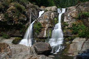
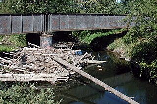
Salt Creek Falls is a cascade and plunge waterfall on Salt Creek, a tributary of the Middle Fork Willamette River, that plunges into a gaping canyon near Willamette Pass in the Willamette National Forest, near Oakridge, Oregon. The waterfall is notable for its main drop of 286 feet (87 m) which makes it the third highest plunge waterfall in Oregon after Multnomah Falls and Watson Falls the second highest, which was re-measured in 2009 and found to be 293 feet rather than an earlier measurement of 272 feet passing Salt Creek Falls. The pool at the bottom of the waterfall is 20 metres (66 ft) deep.

Silver Creek (Marion County, Oregon) river in Marion County, United States of America

Silver Creek is a stream, about 16 miles (26 km) long, in Marion County, Oregon, United States. It is a tributary of the Pudding River and originates in Silver Falls State Park in the Cascade foothills above the cities Silverton and Stayton.

Coyote Creek (San Gabriel River tributary) stream in Southern California, tributary of the San Gabriel River

Coyote Creek is a principal tributary of the San Gabriel River in northwest Orange County, southeast Los Angeles County, and southwest Riverside County, California. It drains a land area of roughly 41.3 square miles (107 km2) covering five major cities, including Brea, Buena Park, Fullerton, La Habra, and La Palma. Some major tributaries of the creek in the highly urbanized watershed include Brea Creek, Fullerton Creek, and Carbon Creek. The mostly flat creek basin is separated by a series of low mountains, and is bounded by several small mountain ranges, including the Chino Hills, Puente Hills and West Coyote Hills.

Big Butte Creek river in Oregon, United States of America

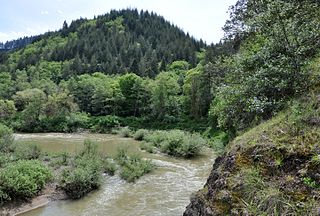
Big Butte Creek is a 12-mile-long (19 km) tributary of the Rogue River in the U.S. state of Oregon. It drains approximately 245 square miles (635 km2) of Jackson County. Its two forks, the North Fork and the South Fork, both begin high in the Cascade Range near Mount McLoughlin. Flowing predominantly west, they meet near the city of Butte Falls. The main stem flows generally northwest until it empties into the Rogue Falls was incorporated in 1911, and remains the only incorporated town within the watershed's boundaries.

North Fork Coquille River river in the United States of America

The North Fork Coquille River is a 53-mile (85 km) tributary of the Coquille River in the southern Oregon Coast Range in the U.S. state of Oregon. It begins at an elevation of about 1,700 feet (520 m) above sea level and drops to 13 feet (4.0 m) near Myrtle Point, where it joins the South Fork Coquille River to form the main stem.

Whychus Creek river in the United States of America

Whychus Creek is a tributary of the Deschutes River in Deschutes and Jefferson counties in the U.S. state of Oregon. Formerly named Squaw Creek, considered derogatory in the 21st century, it was renamed in 2006. Explorer John C. Frémont camped along the stream in 1843 but did not identify it by name. Robert S. Williamson, a surveyor who camped there in 1855, said its Indian name was Why-chus.

Salt Creek (Middle Fork Willamette River tributary) river in the United States of America

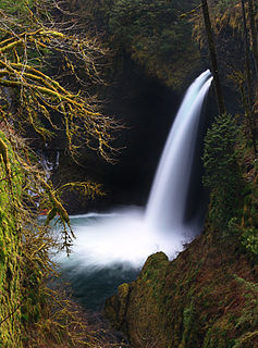
Salt Creek is a tributary, 30 miles (48 km) long, of the Middle Fork Willamette River in Lane County in the U.S. state of Oregon. It is named for salt springs along its banks that are used as licks by deer. The stream originates as an outflow of Lower Betty Lake in the forested Cascade Range just southeast of Waldo Lake. From its source, Salt Creek flows generally south, through Gold Lake, to Route 58, which it then follows mainly northwest for about 26 miles (42 km) to its mouth at the Middle Fork Willamette River just below Hills Creek Dam. At Salt Creek Falls—roughly 4 miles (6.4 km) west of Willamette Pass and a little more than 22 miles (35 km) upstream from the mouth—the stream plunges 286 feet (87 m), discharging an average of 50,000 U.S. gallons (190,000 L) of water per minute, or 111 cubic feet per second (3.1 m3/s). Below the falls, the creek enters a narrow canyon shaped by glaciation and basalt lava flows from higher in the Cascades. McCredie Hot Springs, at the former community of McCredie Springs, are natural hot springs along the lower half of Salt Creek beside Route 58.

Willamina Creek river in the United States of America

Willamina Creek is a tributary, about 20 miles (32 km) long, of the South Yamhill River in the U.S. state of Oregon. Beginning in the Northern Oregon Coast Range in Yamhill County, it briefly enters and exits a small part of eastern Tillamook County, then flows generally south to meet the larger stream at Willamina, near the border with Polk County.

Sandy Creek (Middle Fork Coquille River)

Sandy Creek is a tributary of the Middle Fork Coquille River in the U.S. state of Oregon. It begins near Scott Mountain in the Southern Oregon Coast Range and flows southwest to meet the river near the rural community of Remote. The creek passes under Oregon Route 42 and enters the river about 16 miles (26 km) from its mouth on the South Fork Coquille River near Myrtle Point. The creek's only named tributary is Fetter Creek, which enters from the right slightly upstream of Remote.

Middle Fork Coquille River river in the United States of America

The Middle Fork Coquille River is a tributary, about 40 miles (64 km) long, of the South Fork Coquille River in the U.S. state of Oregon. It begins near Camas Mountain in Douglas County in the Southern Oregon Coast Range. It flows generally south, bypassing the community of Camas Valley while passing through the valley of the same name, then curves west and north to Remote in Coos County. The Middle Fork then flows generally west, passes by the small community of Bridge, and meets the South Fork near Myrtle Point. The confluence with the South Fork is 41 miles (66 km) by water to where the main stem of the Coquille River enters the Pacific Ocean at Bandon.

East Fork Coquille River River in Oregon, US

The East Fork Coquille River is a tributary, about 34 miles (55 km) long, of the North Fork Coquille River in the U.S. state of Oregon. It begins near Bennett Rock in Douglas County in the Southern Oregon Coast Range.

Matilija Wilderness 29,207-acres of Los Padres National Forest in Southern California

The Matilija Wilderness is a 29,207-acre (11,820 ha) wilderness area in Ventura and Santa Barbara Counties, Southern California. It is managed by the U.S. Forest Service, being situated within the Ojai Ranger District of the Los Padres National Forest. It is located adjacent to the Dick Smith Wilderness to the northwest and the Sespe Wilderness to the northeast, although it is much smaller than either one. The Matilija Wilderness was established in 1992 in part to protect California condor habitat.

References

  1. 1 2 3 "South Fork Coquille River". Geographic Names Information System . United States Geological Survey. November 28, 1980. Retrieved March 18, 2011.
  2. Source elevation derived from Google Earth search using GNIS source coordinates.
  3. 1 2 3 "Introduction to the Coquille Watershed". Coquille Watershed Association. Archived from the original on November 17, 2016. Retrieved February 21, 2016.
  4. "Water-Data Report 2009: 14325000 South Fork Coquille River at Powers, OR" (PDF). United States Geological Survey. Retrieved March 18, 2011.
  5. "Water-Data Report 2009: 14325000 South Fork Coquille River at Powers, OR" (PDF). United States Geological Survey. Retrieved March 18, 2011.
  6. 1 2 3 "United States Topographic Map". United States Geological Survey. Retrieved February 21, 2016 via Acme Mapper. The map includes mile markers along the main stem and each large Coquille River fork.
  7. "Upper Coquille River Falls". Northwest Waterfall Survey. January 12, 2008. Retrieved March 18, 2011.
  8. "Coquille River Falls". Northwest Waterfall Survey. September 1, 2007. Retrieved March 18, 2011.
  9. "Coquille River Watershed". Pacific Coast Watershed Partnership. Retrieved March 18, 2011.
  10. "South Fork Coquille Watershed Aquatic Restoration Plan". U.S. Forest Service. August 2007. Retrieved March 18, 2011.