
Roaring Fork River is a tributary of the Colorado River, approximately 70 miles (110 km) long, in west central Colorado in the United States. The river drains a populated and economically vital area of the Colorado Western Slope called the Roaring Fork Valley or Roaring Fork Watershed, which includes the resort city of Aspen and the resorts of Aspen/Snowmass.

The Fryingpan River is a tributary of the Roaring Fork River, approximately 42 miles (68 km) long, in west central Colorado in the United States.

White River is a river, approximately 195 miles (314 km) long, in the U.S. states of Colorado and Utah and is a tributary of the Green River.

The North Fork Gunnison River is a tributary of the Gunnison River, 33.5 miles (53.9 km) long, in southwestern Colorado in the United States. It drains part of the southwestern flank of the Elk Mountains northeast of Delta.
The Middle Fork South Platte River is a tributary of the South Platte River, approximately 50 miles (80 km) long, located in central Colorado in the United States. The river provides part of the drainage of South Park, the intermontane grassland basin located between the Front Range and the Mosquito Range in the Rocky Mountains southwest of Denver.

The Whitewater River is a small permanent stream in western Riverside County, California, with some upstream tributaries in southwestern San Bernardino County. The river's headwaters are in the San Bernardino Mountains and it terminates at the Salton Sea in the Colorado Desert. The area drained by the Whitewater River is part of the larger endorheic Salton Sea drainage basin.

The North Fork White River is a 33.0-mile-long (53.1 km) tributary of the White River. The river's source is Wall Lake in the Flat Tops Wilderness Area of Garfield County, Colorado. It joins with the South Fork White River in Rio Blanco County to form the White River.
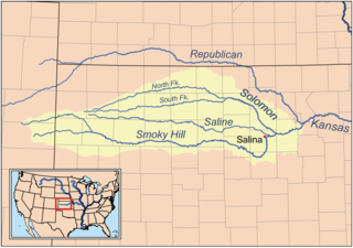
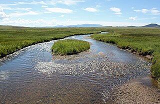
The North Fork Smoky Hill River is a river in the central Great Plains of North America. A tributary of the Smoky Hill River, it flows from eastern Colorado into western Kansas.

Lake Fork Gunnison River or Lake Fork is a 64.7-mile-long (104.1 km) tributary of the Gunnison River in Colorado. The river's source is Sloan Lake near Handies Peak in the San Juan Mountains of Hinsdale County. Lake Fork flows through Lake San Cristobal and Lake City before a confluence with the Gunnison River in Blue Mesa Reservoir.

East Fork Eagle River is an 8.6-mile-long (13.8 km) tributary of the Eagle River in Eagle County, Colorado. The river flows from a source on Chicago Ridge in the White River National Forest to a confluence with the South Fork Eagle River that forms the Eagle River.

South Fork Eagle River is a 6.9-mile-long (11.1 km) tributary of the Eagle River in Eagle County, Colorado. The river flows from a source east of Tennessee Pass in the White River National Forest to a confluence with the East Fork Eagle River that forms the Eagle River.
South Fork San Miguel River is a 6.5-mile-long (10.5 km) tributary of the San Miguel River in San Miguel County, Colorado. The river flows north from a confluence of the Lake Fork and the Howard Fork to a confluence with the San Miguel River west of Telluride.
North Fork Little Snake River is a 13.1-mile-long (21.1 km) tributary of the Little Snake River in Colorado and Wyoming. It flows from a source in the Medicine Bow National Forest of Carbon County, Wyoming to a confluence with the Middle Fork Little Snake River in Routt County, Colorado that forms the Little Snake River.
South Fork Little Snake River is an 18.2-mile-long (29.3 km) tributary of the Little Snake River in Routt County, Colorado. It flows north from a source in Routt National Forest near Steamboat Lake State Park to a confluence with the Little Snake River.

The Williams Fork is a tributary of the Colorado River, approximately 33.8 miles (54.4 km) long, in north central Colorado in the United States. It flows through Grand County between the valleys of the Fraser River and the Blue River. It rises at the juncture of McQueary and Bobtail creeks just west of the Continental Divide 8 miles (13 km) west of Berthoud Pass and 7 miles (11 km) north of the Eisenhower Tunnel in the Arapaho National Forest. It flows north-northwest to the Williams Fork Reservoir, then turns northeast and joins the Colorado at Parshall.
South Fork Piney River is a tributary of the Piney River in Eagle County, Colorado. The river flows north from a source near Red and White Mountain in the White River National Forest to a confluence with the Piney River.
First Fork South Fork Piney River is a tributary of the South Fork Piney River in Eagle County, Colorado. The river flows northeast from a source in the White River National Forest to a confluence with the South Fork Piney River.
South Fork Crystal River is a tributary of the Crystal River in Gunnison County, Colorado, United States. The stream's source is the confluence of Rock Creek and the East Fork in the White River National Forest. It flows through Crystal Canyon to a confluence with the North Fork Crystal River that forms the Crystal River.
East Fork South Fork Crystal River is a tributary of the South Fork Crystal River in Gunnison County, Colorado. The stream's source is on the west side of West Maroon Peak in the Maroon Bells-Snowmass Wilderness. It flows west to a confluence with Rock Creek in the White River National Forest that forms the South Fork Crystal River.

The White River is a 8-mile-long (13 km) southeastward flowing river in Wasatch and Utah Counties in eastern Utah. The White River is tributary to the Price River, which is in turn tributary to the Green River, and then to the Colorado River.
