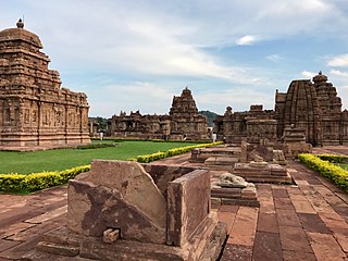
Karnataka, is a state in the southwestern region of India. It was formed as Mysore State on 1 November 1956, with the passage of the States Reorganisation Act, and renamed Karnataka in 1973. The state was part of the Carnatic region in British terminology. Its capital and largest city is Bengaluru (Bangalore).

Mysore, officially Mysuru, is a metropolitan city in the southern Indian state of Karnataka. It is the state's second-most populous and is one of the cleanest cities in India according to the Swachh Survekshan. It is the seat of the Wadiyar dynasty and was the capital of the Kingdom of Mysore for almost six centuries, from 1399 until 1947. It is currently the headquarters of Mysore district and Mysore division. Known for its heritage structures and palaces, including the famous Mysore Palace, and noted for its culture, Mysore is popularly known as the "City of Palaces", the "Heritage City", and the "Cultural Capital of Karnataka". For its pristine and calm ambience, it is also known as "Pensioners' Paradise".
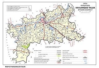
Nanjangud, officially known as Nanjanagudu, is a town in the Mysuru district of Indian state of Karnataka. Nanjangud lies on the banks of the river Kapila, 23 km from the city of Mysore. Nanjangud is famous for the Srikanteshwara Temple located here. Nanjangud is also called Dakshina Kashi. This town is also famous for a type of banana grown in the region called the Nanjanagoodu rasabale. Nanjangud's local administrative unit was designated as a Municipal Committee in 2015 by including Devirammanahalli and Kallahalli village.

Mysore division, officially Mysuru division, is an administrative division in the southern Indian state of Karnataka. It is one of four administrative divisions in Karnataka, the others being Bangalore division, Belagavi division, and Kalaburagi division. Mysore division comprises eight districts of Karnataka, namely, Chamarajanagar, Chikmagalur, Dakshina Kannada, Hassan, Kodagu, Mandya, Mysore and Udupi district. The city of Mysore is the administrative headquarters of the division. Mysore division covers parts of historical Old Mysore region and southern part of Coastal Karnataka.The total area of the division is 43,503 sq.km. The total population as of 2011 census is 12,563,598.
Yelandur is a taluk and town in Chamarajanagar district in southern Karnataka, India. It has historic and cultural importance in this region. Along with three other taluks, it was officially included into Chamarajanagar district when the district was notified upon bifurcation of Mysore district in 1997.

Bangalore is the capital city of the state of Karnataka. Bangalore, as a city, was founded by Kempe Gowda I, who built a mud fort at the site in 1537. But the earliest evidence for the existence of a place called Bangalore dates back to c. 890.
Arsikere is a city and taluka in the Hassan district in the state of Karnataka, India. It is the second largest city in Hassan district, demographically. Arsikere city municipal council consists of 35 wards. This region is known for its coconut production and is also called Kalpataru Nadu. Arsikere Junction is a major railway junction in the South Western Railway which links Mangalore and Mysore to North Karnataka and a central place for tourists who visit nearby places that do not have rail access, such as Belur, Halebidu and Shravanabelagola, Harnahalli, and Kodimata.
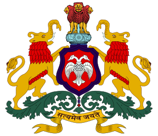
The Government of Karnataka, abbreviated as GoK, or simply Karnataka Government, formerly Government of Mysore, is a democratically elected state body with the governor as the ceremonial head to govern the Southwest Indian state of Karnataka. The governor who is appointed for five years appoints the chief minister and on the advice of the chief minister appoints his council of ministers. Even though the governor remains the ceremonial head of the state, the day-to-day running of the government is taken care of by the chief minister and his council of ministers in whom a great amount of legislative powers are vested.

The Indian State of Karnataka is located between 11°30' North and 18°30' North latitudes and between 74° East and 78°30' East longitude.It is situated on a tableland where the Western Ghats and Eastern Ghats converge into the complex, in the western part of the Deccan Peninsular region of India. The State is bounded by Maharashtra and Goa States in the north and northwest; by the Lakshadweep Sea in the west; by Kerala in the south-west and Tamil Nadu in the south and south-east, Andhra Pradesh in the south-east and east and Telangana in the north-east. Karnataka extends to about 850 km (530 mi) from north to south and about 450 km (280 mi) from east to west.

Karnataka is one of the highest economic growth states in India with an expected GSDP growth of 9.5% in the 2021–22 fiscal year. The total expected GSDP of Karnataka in 2022–2023 is about $240 billion. Karnataka recorded the highest growth rates in terms of GDP and per capita GDP in the last decade compared to other states. In 2008–09, the tertiary sector contributed the most to GSDP, followed by the secondary sector, and the primary sector.

Karnataka, a state in South India has a well-developed transport system. Its capital city, Bengaluru is well-connected by air to domestic and international destinations and the Kempegowda International Airport (KIA) in the city is one of the busiest airports in India. It was also the headquarters of the airlines Air Deccan and Kingfisher Airlines. The road transport is also well developed in the state with many National and State highways providing means for fast transportation. The headquarters of the South-Western Railway division of Indian Railways is located at Hubballi and this division governs most of the railway network in the state. Konkan Railway which passes along the coastal region of the state is considered one of the toughest engineering projects being undertaken in India till date. Buses, cars and trains are the means of transport for moving across distant places in Karnataka. For transportation within the city or town limits; motorbikes, cars, autorickshaws and buses are used. With the advent of low-cost airlines, many people are choosing to travel via air as well.
The Karnataka State Police is the law enforcement agency for the Indian state of Karnataka. It was established in 1965 and is headquartered in Bengaluru, the capital city of Karnataka. The KSP is a state police force that works under the purview of the Department of Home Affairs, Government of Karnataka. The department is headed by the Director General and Inspector General of Police.

The Nandi Infrastructure Corridor Enterprises Road, commonly known as NICE Road, is a partially implemented and largely scrapped 4 to 6 lane private tolled expressway in Karnataka, that was intended to connect the two important cities Bengaluru and Mysuru in the Indian state of Karnataka. It will not be implemented, as Bengaluru-Mysuru access-controlled Highway part of NH 275 is going to replace it as a section of the new Bengaluru-Mangaluru Industrial Corridor (EC-34).
Karnataka is a state in the southern part of India. It was created on 1 November 1956, with the passing of the States Reorganisation Act. Karnataka is bordered by the Arabian Sea to the west, Goa to the north-west, Maharashtra to the north, Telangana and Andhra Pradesh to the east, Tamil Nadu to the south-east, and Kerala to the south-west. The state covers an area of 74,122 sq mi (191,976 km2), or 5.83% of the total geographical area of India. It comprises 30 districts. Kannada is the official language of Karnataka and as per the 2011 census is the mother tongue of 66.5% of the population. Various ethnic groups with origins in other parts of India have unique customs and use languages at home other than Kannada, adding to the cultural diversity of the state. Significant linguistic minorities in the state in 2011 included speakers of Urdu (10.8%), Telugu (5.8%), Tamil (3.5%), Marathi (3.4%), Hindi (3.2%), Tulu (2.6%), Konkani (1.3%) and Malayalam (1.3%).
The Karnataka flag is unofficial, a bicolour of yellow and red, symbolises Kannada.

The following outline is provided as an overview of and topical guide to Karnataka:

Bangalore, officially Bengaluru, is the capital and largest city of the southern Indian state of Karnataka. It has a population of more than 8 million and a metropolitan population of around 15 million, making it India's third most populous city and fourth most populous urban agglomeration. It is the most populous city and largest urban agglomeration in South India, and is the 27th largest city in the world. Located on the Deccan Plateau, at a height of over 900 m (3,000 ft) above sea level, Bangalore has a pleasant climate throughout the year, with its parks and green spaces earning it the reputation of India's "Garden City". Its elevation is the highest of India's major cities.
Jayciana is the annual cultural festival of the Sri Jayachamarajendra College of Engineering, Mysuru usually held during April – May.

Aryamba Pattabhi is an Indian novelist and writer in Kannada language. She is the younger sister of Triveni, a popular Kannada novelist and the niece of B. M. Srikantaiah, a famous Kannada poet, writer and translator.
