
The Drakensberg is the eastern portion of the Great Escarpment, which encloses the central Southern African plateau. The Great Escarpment reaches its greatest elevation – 2,000 to 3,482 metres within the border region of South Africa and Lesotho.

The Phetchabun mountains are a mountain massif in Phetchabun, Phitsanulok, Loei and Chaiyaphum Provinces, Thailand. It consists of two parallel mountain chains, with the valley of the Pa Sak River in the middle.

The Sierra Madre Oriental is a mountain range in northeastern Mexico. The Sierra Madre Oriental is part of the American Cordillera, a chain of mountain ranges (cordillera) that consists of an almost continuous sequence of mountain ranges that form the western "backbone" of North America, Central America, South America, and Antarctica.

Same is one of the seven districts of the Kilimanjaro Region of Tanzania. It is bordered to the north by the Mwanga District, to the northeast by Kenya, to the south and southeast by the Korogwe District and Lushoto District of Tanga Region, and to the west by Simanjiro District of Manyara Region. The district capital is the town of Same, Tanzania. The south Pare Mountains are located within the district's boundaries and so is a part of Mkomazi National Park. According to the 2002 Tanzania National Census, the population of the Same District was 212,235. The population had risen to 269,807 according to the 2012 Tanzania National Census.
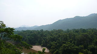
The Pare Mountains are a mountain range in northeastern Tanzania, located north of the Usambara Mountains. The mountains are administratively located in the Kilimanjaro Region, specifically in the Mwanga District and Same District. The North and South Pare mountain ranges reach a height of 2,463 meters at Shengena Peak. They are separated into North Pare Mountains and South Pare Mountains and are part of the Eastern Arc of mountains. The mountains are named after the indigenous Pare people who reside there.
The Uluguru mountains are a mountain range in eastern Tanzania, named after the Luguru tribe. The main portion of the Uluguru mountains is a ridge running roughly north-south and rising to 2,630 metres (8,600 ft) altitude at its highest point. On the main Uluguru range, 50 villages touch the forest boundary and over 151,000 people are found within the mountain area, often at increasing densities at higher altitudes up to the forest boundary.

The New Guinea Highlands, also known as the Central Range or Central Cordillera, is a long chain of mountain ranges on the island of New Guinea, including the island's tallest peak, Puncak Jaya 16,024 ft (4,884 m), the highest mountain in Oceania. The range is home to many intermountain river valleys, many of which support thriving agricultural communities. The highlands run generally east-west the length of the island, which is divided politically between Indonesia in the west and Papua New Guinea in the east.
The Tenasserim Hills or Tenasserim Range is the geographical name of a roughly 1,700 km long mountain chain, part of the Indo-Malayan mountain system in Southeast Asia.

Sa Pa is a district-level town of Lào Cai Province in the Northwest region of Vietnam. As of 2018, the town had a population of 61,498. The town covers an area of 677 km2. The town capital lies at Sa Pa. It is one of the main market towns in the area, where several ethnic minority groups such as Hmong, Dao (Yao), Giáy, Xa Pho, and Tay live.

The Central Mountain Range is a physiogeographical region encompassing the central and eastern edge of Albania. It comprises the mountainous inland extending all the way from the valley of Drin and the mountains of Sharr, Skanderbeg, Korab, and Shebenik-Jabllanicë, through the lakes of Ohrid and Prespa, until it reaches the village of Ersekë and the mountains of Pindus close to the border between the country and Greece.

The Imatong Mountains are mainly located in Eastern Equatoria in southeastern South Sudan, and extend into the Northern Region of Uganda. Mount Kinyeti is the highest mountain of the range at 3,187 metres (10,456 ft), and the highest point of South Sudan.
The Itombwe Mountains are a range of mountains in the South Kivu province of the Democratic Republic of the Congo (DRC). They run along the west shore of the northern part of Lake Tanganyika. They contain a vast area of contiguous montane forest and are home to a rich diversity of wildlife.
Chome Forest Reserve is a reserve in the Pare Mountains in Tanzania. It is located between the West Usambaras and the North Pare Mountains. It lies in Pare District of Kilimanjaro Region.
The Eastern Arc forests is a montane tropical moist forest ecoregion of eastern Africa. The ecoregion comprises several separate highland areas above 800 meters in Kenya, and (mostly) Tanzania.
Callulina shengena is a species of frogs in the family Brevicipitidae. It was discovered in 2010 during a survey of rainforests in the northern part of the Eastern Arc Mountains of Tanzania. It is present at two locations in Chome Forest Reserve at altitudes between 1,920 and 2,100 m. The forests in which it lives are being selectively felled, and the International Union for Conservation of Nature has rated its conservation status as "critically endangered".
Callulina stanleyi is a species of frogs in the family Brevicipitidae. It was discovered in 2010 during a survey of rainforests in the northern part of the Eastern Arc Mountains of Tanzania. It was named in honour of the American zoologist, William T. Stanley, of the Field Museum, Chicago, who has done much research into the amphibians of Tanzania. It is present at three locations along the eastern border of Chome Forest Reserve at altitudes between 1,100 and 1,300 m. It is rated as "critically endangered" by the International Union for Conservation of Nature.

The Altai montane forest and forest steppe ecoregion covers patches of the subalpine forest belt on the Altai Mountains, crossing the border region where Russia, Kazakhstan, Mongolia and China meet. The region has high biodiversity, as it is located in transition zones between different ecoregions, altitudes, and climate zones. It is in the Palearctic realm, with a Cold semi-arid climate. It covers 35,199,998 km2 (13,590,795 sq mi).
Ntchisi Mountain is a mountain in central Malawi. It is located in Ntchisi District, east of the town of Ntchisi.
The Misuku Hills are a mountain range in Malawi's Northern Region.

The North Pare Mountains is a mountain range located entirely within Mwanga District of Kilimanjaro Region of northern Tanzania, extending from Ruvu River on the border with Moshi Rural District to Mgagao Ward in on the border with Same District. The range is part of East Africa's Eastern Arc Mountains chain known as the Pare Mountains. The other range is the South Pare Mountains. The North Pare and South Pare mountains are named after the original inhabitants of the area, the Pare people. The average elevation of the highlands is 1613m. The highest peak in the North Pare is Kindoroko Peak at 2,100m. The North Pare Mountains are divided into four ranges, Mramba in the northeast, Ngofe in the north, Mruma in the center, and Mwanga Ndorowe to the south. The mountains are also home to archaeological sites of ancient iron smithing done by the ancestors of the Pare. Currently, there are three protected forests on the mountain range; Kindoroko, Minja, and Mramba forest reserves.