
Gloucestershire is a ceremonial county in South West England. It is bordered by Herefordshire to the north-west, Worcestershire to the north, Warwickshire to the north-east, Oxfordshire to the east, Wiltshire to the south, Bristol and Somerset to the south-west, and the Welsh county of Monmouthshire to the west. The city of Gloucester is the largest settlement and the county town.
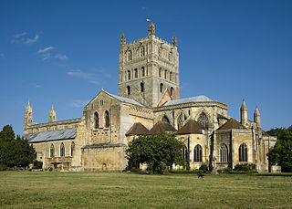
The Abbey Church of St Mary the Virgin, Tewkesbury, commonly known as Tewkesbury Abbey, is located in the English county of Gloucestershire. A former Benedictine monastery, it is now a parish church. Considered one of the finest examples of Norman architecture in Britain, it has the largest Romanesque crossing tower in Europe.

Cheltenham, also known as Cheltenham Spa, and sometimes called "the Garden Town of England", is a spa town on the edge of the Cotswolds in the county of Gloucestershire, England. It is also a local government district with borough status. Cheltenham became known as a health and holiday spa town resort, following the discovery of mineral springs in 1716, and claims to be the most complete Regency town in Britain.
Bishop's Cleeve is a large village and civil parish in the Borough of Tewkesbury in the ceremonial county of Gloucestershire, England. The village lies at the foot of Cleeve Hill, the highest point in the Cotswolds. Bishop's Cleeve had a population of 10,612 in 2011, which has increased to 14,068 in the 2021 Census. The village is located 99 miles (159 km) from London, 13 miles (21 km) from Gloucester, 57 miles (92 km) from Birmingham and 44 miles (71 km) from Oxford. The village is also close to the towns of Cheltenham, Tewkesbury, Stratford-upon-Avon and Evesham.

The region now known as Gloucestershire was originally inhabited by Brythonic peoples in the Iron Age and Roman periods. After the Romans left Britain in the early 5th century, the Brythons re-established control but the territorial divisions for the post-Roman period are uncertain. The city of Caerloyw was one centre and Cirencester may have continued as a tribal centre as well. The only reliably attested kingdom is the minor south-east Wales kingdom of Ergyng, which may have included a portion of the area. In the final quarter of the 6th century, the Saxons of Wessex began to establish control over the area.

Whitminster is a village and civil parish in Gloucestershire, England, and on the A38 trunk road approximately 6 miles (10 km) south of Gloucester and 6 miles (10 km) north-west of Stroud. The parish population at the 2011 census was 881. The hamlet of Wheatenhurst is signposted from the A38 at Whitminster. Whitminster is close to the M5 motorway, with Bristol, South Wales and the south Midlands all within an hour's drive.
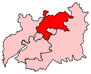
Tewkesbury is a constituency in Gloucestershire represented in the House of Commons of the UK Parliament since its 1997 recreation by Laurence Robertson, a Conservative.

Woodmancote is a village and civil parish in Gloucestershire, England. The parish lies immediately east of Bishop's Cleeve; the village is about 3+1⁄2 miles (6 km) north of Cheltenham. In old English the name meant 'woodmen's cottage' and an early form was Wudumannacote. In the southeast of the parish is the small village of Cleeve Hill, under the slopes of the hill of the same name.

Miles FitzWalter of Gloucester, 1st Earl of Hereford was a great magnate based in the west of England. He was hereditary Constable of England and Sheriff of Gloucestershire.

Gotherington is a small village north of Bishops Cleeve in Gloucestershire, England. It is surrounded on the north by the villages of Woolstone and Oxenton, and to the south by Woodmancote and Bishop's Cleeve, a very large urban village. Gotherington has a population of around 1,200, while its neighbour, Bishops Cleeve, has a population of 15,000. The populations reduced at the 2011 census to 995 for Gotherington.

Umberleigh is a former large manor within the historic hundred of (North) Tawton, but today a small village in North Devon in England. It used to be an ecclesiastical parish, but following the building of the church at Atherington it became a part of that parish. It forms however a part of the civil parish of Chittlehampton, which is mostly located on the east side of the River Taw.

Llanthony Secunda Priory was a house of Augustinian canons in the parish of Hempsted, Gloucestershire, England, situated about 1/2 a mile south-west of Gloucester Castle in the City of Gloucester. It was founded in 1136 by Miles de Gloucester, 1st Earl of Hereford, a great magnate based in the west of England and the Welsh Marches, hereditary Constable of England and Sheriff of Gloucestershire, as a secondary house and refuge for the canons of Llanthony Priory in the Vale of Ewyas, within his Lordship of Brecknock in what is now Monmouthshire, Wales. The surviving remains of the Priory were designated as Grade I listed in 1952 and the wider site is a scheduled ancient monument. In 2013 the Llanthony Secunda Priory Trust received funds for restoration work which was completed in August 2018 when it re-opened to the public.

Seend is a village and civil parish about 3 miles (5 km) southeast of the market town of Melksham, Wiltshire, England. It lies about 3.5 miles (6 km) west of Devizes and 5.5 miles (9 km) northeast of the county town of Trowbridge. The parish includes the sub-village of Seend Cleeve and the hamlets of Inmarsh, Martinslade, Seend Head, Sells Green and The Stocks.

Notgrove is a village and civil parish in Gloucestershire, England, approximately 28.5 to the east of Gloucester. It lies in the Cotswolds, an Area of Outstanding Natural Beauty.

Sedgeberrow is a village and civil parish in the Wychavon district of Worcestershire, England, about 3 miles (4.8 km) south of Evesham. It stands beside the River Isbourne, a tributary of the River Avon.

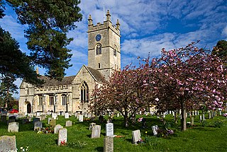
St Michael & All Angels is the Anglican church in the village of Bishop's Cleeve, just north of Cheltenham in Gloucestershire. Informally the church is known simply as St Michael's.

Ellenborough Park Hotel is a country house hotel in Southam, about 2+1⁄2 miles (4.0 km) northeast of the centre of Cheltenham, Gloucestershire, England. It is a Grade II* listed building.
Weston-sub-Edge is a village in Gloucestershire, England.
Kinard de la Bere was an English landowner and MP. He was the son of John de la Bere of Southam, Gloucestershire and Anne, daughter of John Stephens of Lypiatt, Gloucestershire. The various branches of his mother's family frequently represented Gloucestershire in parliament. In 1699 he married Hester, the daughter and co-heiress of John Neale of Nether Dean, Beds. Her sister Anne had married his mother's nephew Thomas Stephens, a Whig MP for Gloucestershire from 1713 until his death in 1720. At the general election in 1722 he was returned to sit for Gloucestershire through the influence of the Stephens. He served only one term and did not stand in the following election. He died childess and his estate was inherited by his nephew William Baghot, who assumed the name De la Bere.


