
The ionosphere is the ionized part of the upper atmosphere of Earth, from about 48 km (30 mi) to 965 km (600 mi) above sea level, a region that includes the thermosphere and parts of the mesosphere and exosphere. The ionosphere is ionized by solar radiation. It plays an important role in atmospheric electricity and forms the inner edge of the magnetosphere. It has practical importance because, among other functions, it influences radio propagation to distant places on Earth. Travel through this layer also impacts GPS signals, resulting in effects such as deflection in their path and delay in the arrival of the signal.
Radar is a system that uses radio waves to determine the distance (ranging), direction, and radial velocity of objects relative to the site. It is a radiodetermination method used to detect and track aircraft, ships, spacecraft, guided missiles, motor vehicles, map weather formations, and terrain.

The High-frequency Active Auroral Research Program (HAARP) is a University of Alaska Fairbanks program which researches the ionosphere – the highest, ionized part of Earth's atmosphere. The most prominent instrument at HAARP is the Ionospheric Research Instrument (IRI), a high-power radio frequency transmitter facility operating in the high frequency (HF) band. The IRI is used to temporarily excite a limited area of the ionosphere. Other instruments, such as a VHF and a UHF radar, a fluxgate magnetometer, a digisonde, and an induction magnetometer, are used to study the physical processes that occur in the excited region. Work on the HAARP facility began in 1993. Initially HAARP was jointly funded by the U.S. Air Force, the U.S. Navy, the University of Alaska Fairbanks, and the Defense Advanced Research Projects Agency (DARPA). It was designed and built by BAE Advanced Technologies. Its original purpose was to analyze the ionosphere and investigate the potential for developing ionospheric enhancement technology for radio communications and surveillance. Since 2015 it has been operated by the University of Alaska Fairbanks.

The Poker Flat Research Range (PFRR) is a launch facility and rocket range for sounding rockets in the U.S. state of Alaska, located on a 5,132-acre (20.77 km2) site at Chatanika, about 30 miles (50 km) northeast of Fairbanks and 1.5 degrees south of the Arctic Circle. More than 1,700 launches have been conducted at the range to study the Earth's atmosphere and the interaction between the atmosphere and the space environment. Areas studied at PFRR include the aurora, plasma physics, the ozone layer, solar proton events, Earth's magnetic field, and ultraviolet radiation. Rockets launched at PFRR have attained an apogee of 930 miles (1,500 km).

Over-the-horizon radar (OTH), sometimes called beyond the horizon radar (BTH), is a type of radar system with the ability to detect targets at very long ranges, typically hundreds to thousands of kilometres, beyond the radar horizon, which is the distance limit for ordinary radar. Several OTH radar systems were deployed starting in the 1950s and 1960s as part of early-warning radar systems, but airborne early warning systems have generally replaced these. OTH radars have recently been making a comeback, as the need for accurate long-range tracking has become less important since the ending of the Cold War, and less-expensive ground-based radars are once again being considered for roles such as maritime reconnaissance and drug enforcement.
Low-frequency radar is radar which uses frequencies lower than 1 GHz such as L-band, UHF, VHF, and HF, as opposed to the usual radar bands, which range from 2 GHz to 40 GHz.The radar cross section of any target depends on the frequency transmitted by the radar. Below 900 MHz the target radar cross section increases exponentially, however the increased radar cross section means that there is also much more radar return from undesirable sources, such as cloud cover and rain. It is because of this that radars traditionally use much higher frequencies, with an exception being the radars operated in the 3-30 MHz band which are used as over-the-horizon radar stations because signals in that range are able to reflect off the ionosphere.

A radar altimeter (RA), also called a radio altimeter (RALT), electronic altimeter, reflection altimeter, or low-range radio altimeter (LRRA), measures altitude above the terrain presently beneath an aircraft or spacecraft by timing how long it takes a beam of radio waves to travel to ground, reflect, and return to the craft. This type of altimeter provides the distance between the antenna and the ground directly below it, in contrast to a barometric altimeter which provides the distance above a defined vertical datum, usually mean sea level.

The Super Dual Auroral Radar Network (SuperDARN) is an international scientific radar network consisting of 35 high frequency (HF) radars located in both the Northern and Southern Hemispheres. SuperDARN radars are primarily used to map high-latitude plasma convection in the F region of the ionosphere, but the radars are also used to study a wider range of geospace phenomena including field aligned currents, magnetic reconnection, geomagnetic storms and substorms, magnetospheric MHD waves, mesospheric winds via meteor ionization trails, and interhemispheric plasma convection asymmetries. The SuperDARN collaboration is composed of radars operated by JHU/APL, Virginia Tech, Dartmouth College, the Geophysical Institute at the University of Alaska Fairbanks, the Institute of Space and Atmospheric Studies at the University of Saskatchewan, the University of Leicester, Lancaster University, La Trobe University, the Solar-Terrestrial Environment Laboratory at Nagoya University, the British Antarctic Survey and the Institute for Space Astrophysics and Planetology.

An early-warning radar is any radar system used primarily for the long-range detection of its targets, i.e., allowing defences to be alerted as early as possible before the intruder reaches its target, giving the air defences the maximum time in which to operate. This contrasts with systems used primarily for tracking or gun laying, which tend to offer shorter ranges but offer much higher accuracy.
The Geophysical Institute of the University of Alaska Fairbanks conducts research into space physics and aeronomy; atmospheric sciences; snow, ice, and permafrost; seismology; volcanology; and tectonics and sedimentation. It was founded in 1946 by an act of the United States Congress.

Canadian Geospace Monitoring (CGSM) is a Canadian space science program that was initiated in 2005. CGSM is funded primarily by the Canadian Space Agency, and consists of networks of imagers, meridian scanning photometers, riometers, magnetometers, digital ionosondes, and High Frequency SuperDARN radars. The overarching objective of CGSM is to provide synoptic observations of the spatio-temporal evolution of the ionospheric thermodynamics and electrodynamics at auroral and polar latitudes over a large region of Canada.
An ionospheric heater, or an ionospheric HF pump facility, is a powerful radio wave transmitter with an array of antennas which is used for research of plasma turbulence, the ionosphere and upper atmosphere.
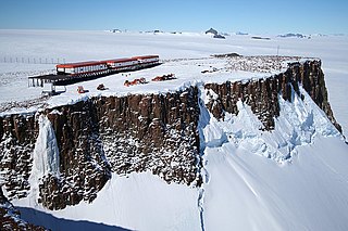
SANAE IV is a current South African Antarctic research base located in Vesleskarvet, Queen Maud Land. The base is part of the South African National Antarctic Program (SANAP) and is operated by the South African National Antarctic Expedition.

Terence James Elkins is an Australian-born American physicist. In 1960, he participated in an expedition from Mawson Station which conducted the first geological surveys of the Napier Mountains in Enderby Land, East Antarctica. The highest of this group of mountains, Mount Elkins, was subsequently named after him. In 1979, he received the Harold Brown Award, the United States Air Force's highest honor for research and development, for research he conducted that contributed to the development of the AN/FPS-115, AN/FPS-117 and AN/FPS-118 over-the-horizon backscatter (OTH-B) air defense radar system. Designed to replace the aging Ballistic Missile Early Warning System, these systems are among the most powerful early-warning radar systems ever developed.
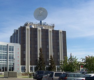
The Unwin Radar is a scientific radar array at Awarua, near Invercargill, New Zealand 46.51°S 168.38°E.

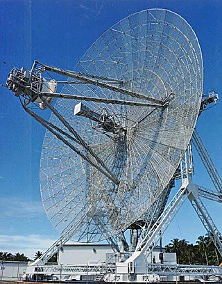
The Millstone Hill Steerable Antenna, or MISA, is a fully steerable dish antenna, 46 metres (151 ft) in diameter, designed by the Stanford Research Institute (SRI) in 1959. It is currently located at MIT Haystack Observatory in Westford, Massachusetts.
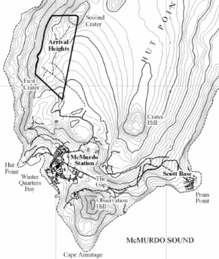
Arrival Heights are clifflike heights which extend in a north-east–south-west direction along the west side of Hut Point Peninsula, just north of Hut Point in Ross Island, Antarctica. They were discovered and named by the British National Antarctic Expedition, 1901–04, under Robert Falcon Scott. The name suggests the expedition's arrival at its winter headquarters at nearby Hut Point.
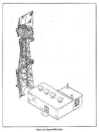
The AN/FPS-14 was a medium-range search Radar used by the United States Air Force Air Defense Command.
Cooperative Engagement Capability (CEC) is a sensor network with integrated fire control capability that is intended to significantly improve battle force air and missile defense capabilities by combining data from multiple battle force air search sensors on CEC-equipped units into a single, real-time, composite track picture. This will greatly enhance fleet air defense by making jamming more difficult and allocating defensive missiles on a battle group basis.

IFF Mark II was the first operational identification friend or foe system. It was developed by the Royal Air Force just before the start of World War II. After a short run of prototype Mark Is, used experimentally in 1939, the Mark II began widespread deployment at the end of the Battle of Britain in late 1940. It remained in use until 1943, when it began to be replaced by the standardised IFF Mark III, which was used by all Allied aircraft until long after the war ended.
