Google Maps is a web mapping platform and consumer application offered by Google. It offers satellite imagery, aerial photography, street maps, 360° interactive panoramic views of streets, real-time traffic conditions, and route planning for traveling by foot, car, bike, air and public transportation. As of 2020, Google Maps was being used by over one billion people every month around the world.

The Ohio and Erie Canal was a canal constructed during the 1820s and early 1830s in Ohio. It connected Akron with the Cuyahoga River near its outlet on Lake Erie in Cleveland, and a few years later, with the Ohio River near Portsmouth. It also had connections to other canal systems in Pennsylvania.

Google Earth is a computer program that renders a 3D representation of Earth based primarily on satellite imagery. The program maps the Earth by superimposing satellite images, aerial photography, and GIS data onto a 3D globe, allowing users to see cities and landscapes from various angles. Users can explore the globe by entering addresses and coordinates, or by using a keyboard or mouse. The program can also be downloaded on a smartphone or tablet, using a touch screen or stylus to navigate. Users may use the program to add their own data using Keyhole Markup Language and upload them through various sources, such as forums or blogs. Google Earth is able to show various kinds of images overlaid on the surface of the earth and is also a Web Map Service client. In 2019, Google revealed that Google Earth now covers more than 97 percent of the world, and has captured 10 million miles of Street View imagery.
Keyhole Markup Language (KML) is an XML notation for expressing geographic annotation and visualization within two-dimensional maps and three-dimensional Earth browsers. KML was developed for use with Google Earth, which was originally named Keyhole Earth Viewer. It was created by Keyhole, Inc, which was acquired by Google in 2004. KML became an international standard of the Open Geospatial Consortium in 2008. Google Earth was the first program able to view and graphically edit KML files, but other projects such as Marble have added KML support.

Proceratium google, also known as the Google ant, was discovered in Madagascar by Brian L. Fisher, Associate Curator of Entomology at the California Academy of Sciences. The ant has an oddly shaped abdomen, adapted for hunting its exclusive meal of spider eggs.
Siirt Airport is an airport in Siirt, the city in Southeastern Anatolian region of Turkey.
Kumaka is a village in the East Berbice–Corentyne region of Guyana. It stands on the right bank of the upper Essequibo River, about 35 km above Apoteri and the confluence of the Rupununi River with the Essequibo, at an elevation of 105 metres (344 ft).

Reg District is located in the southern part of Kandahar Province in Afghanistan. It borders Helmand Province to the west, Panjwai and Daman districts to the north, Shorabak District to the east and Chagai District in Balochistan, Pakistan, to the south.
Mu Se District is a district of the Shan State in Burma (Myanmar). As of 2001, it consisted of 4 towns and 1162 villages. The capital is at Muse.
Mong Hsat District or Mongsat District is a district of the Shan State in Myanmar. It consists of 2 townships 5 towns and 1095 villages.
Bashanabad is a village in Wurduj District, Badakhshan Province in north-eastern Afghanistan.
Bahadorkhan is a village in Badghis Province in north western Afghanistan.
Google Building Maker was a web application that allowed users to build three-dimensional buildings for inclusion in Google Earth. Buildings were created using simple three-dimensional shapes combined with aerial photos. Google reviewed new building submissions and included them in Google Earth's three-dimensional buildings layer when they were of sufficient quality and a better model did not already exist. Building models could be exported for editing in SketchUp. There were at least 127 cities available.

Darwaz Airport is located next to the Panj River in Darwaz, which is the capital of Darwaz District in Badakhshan Province of Afghanistan. Situated at an elevation of 5,066 feet (1,544 m) above sea level, the airfield has a gravel runway measuring around 2,145 by 100 feet. The name Darwaz is Persian and refers to an entry or a gateway.
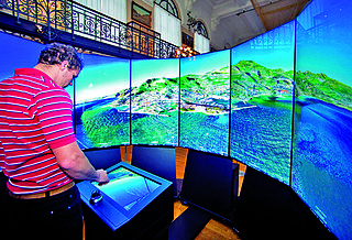
The Liquid Galaxy is an open source project founded by Google. Created in 2008 by Google employee Jason Holt, the Liquid Galaxy started out as a panoramic multi-display Google Earth viewer, but shifted to a general data visualization tool for various uses including operations, marketing, and research.
Where on Google Earth is Carmen Sandiego? is a series of three video games utilising Google Earth released as tie-ins to the animated series released in the same year. To develop the series, Houghton Mifflin Harcourt partnered with Google. The games utilize the Google Earth software, and runs as an add-on that can be played by clicking the icon of Carmen Sandiego. The game is played by Google's Chrome web browser on a PC, or with the Google Earth app on iOS and Android devices. It aims to be a reimagining of the original 1985 video game, using Google Earth.
The Billion Dollar Code is a 2021 German television miniseries starring Björn Freiberg, Seumas F. Sargent and Leonard Scheicher. Based on true events, the series was developed for Netflix, where it was first aired in October 2021 along with an additional feature story episode.