The Delta Hotels Bessborough, formerly and commonly known as the Bessborough, is a historic hotel in Saskatoon, Saskatchewan, Canada. The hotel is within the Central Business District, a commercial district in Saskatoon. The Bessborough was designed by Archibald and Schofield for Canadian National Hotels, a division of Canadian National Railway.

The Traffic Bridge is the name given to two truss bridges constructed across the South Saskatchewan River, connecting Victoria Avenue to 3rd Avenue South and Spadina Crescent in Saskatoon, Saskatchewan, Canada. The original bridge opened on October 10, 1907, and was the first bridge to carry motor vehicle traffic in Saskatoon, replacing an unreliable ferry service. The promised construction of the bridge was considered a prime factor in the amalgamation of the towns of Saskatoon, Nutana and Riversdale into one city named Saskatoon. The Traffic Bridge was the only road bridge in Saskatoon until 1916, when the University Bridge was completed. In 2010, the bridge was permanently closed due to severe corrosion and was demolished by 2016.

The Cathedral of St. John the Evangelist, located at 816 Spadina Crescent East in the Central Business District neighbourhood of Saskatoon, Saskatchewan, Canada is the cathedral of the Anglican Diocese of Saskatoon.

Canada is a constitutional monarchy, and connections to the Canadian Crown in Saskatoon, the most populous city in the Canadian province of Saskatchewan, are visible in visits from the Sovereign of Canada, the Canadian Royal Family and vice-regal representatives, and also in the prominence of names and symbols in civic traditions. The Crown's image appears in the centrepiece portrait at Saskatoon City Council chamber and also in the badges of Saskatoon Police Service officers. On one of several visits to Saskatoon, Queen Elizabeth II said "Constitutional Monarchy has always placed the emphasis on people in community – as it were, a national family with the Sovereign as its head." Saskatoon's manifold connections include more than a dozen royal visits, frequent vice-regal visitors, namesakes for schools, streets and neighbourhoods, and the regular inclusion of its own namesake, the saskatoon berry, on menus for royal and vice-regal functions. Canada's 2008 definitive postage stamp features a photograph of Queen Elizabeth II taken in Saskatoon.

The Central Business District is one of seven development districts in Saskatoon, Saskatchewan, Canada. The central business district is Ward 6 of a Mayor-Council government represented by councillor Cynthia Block. Formerly called West Saskatoon, this area arose when the steam engines built their pumping stations on the lower west bank of the South Saskatchewan River. Retail enterprises sprang up around the newly created train station and rail yards. The city of Saskatoon's Central Business District has shopping malls and boutiques.

Arbor Creek is a primarily residential neighbourhood located in northeast Saskatoon, Saskatchewan, Canada. It is mostly made up of low-density single detached dwellings. As of 2006, the area is home to 4,654 residents. The neighbourhood is considered a high-income area, with an average family income of $99,631, an average dwelling value of $327,262 and a home ownership rate of 92.5%.

Grosvenor Park is a mostly residential neighbourhood located in east-central Saskatoon, Saskatchewan, Canada. It is a suburban subdivision, composed of a near-even mix of low-density, single detached dwellings and apartment-style units. As of 2006, the area is home to 1,645 residents. The neighbourhood is considered an upper-income area, with an average family income of $67,544, an average dwelling value of $329,988 and a home ownership rate of 44.8%.

Lawson Heights is a residential neighbourhood located in northern Saskatoon, Saskatchewan, which was developed beginning in the late 1970s.

King George is an older inner city neighbourhood located near the centre of Saskatoon, Saskatchewan, Canada. It consists mostly of low-density, single detached dwellings. As of 2011, the area is home to 1,902 residents. The neighbourhood is considered a lower-income area with an average family income of $47,581, an average dwelling value of $146,941 and a home ownership rate of 69.1%.

City Park is a mixed-use neighbourhood located near the center of Saskatoon, Saskatchewan, Canada. It comprises a mix of single-family detached homes, apartment buildings and other semi-detached dwellings. It also contains a number of commercial zones with businesses. As of 2009, the area was home to 4,405 residents. The neighbourhood is considered a middle-income area, with an average family income of $42,236, an average dwelling value of $245,254 and a home ownership rate of 28.6%.

Holiday Park is a neighbourhood in south-central Saskatoon, Saskatchewan. Located within Saskatoon's Ward 2, Councillor Hilary Gough represents the area's interests at City Hall.

Lakeview is a primarily residential neighbourhood located in the southeast part of Saskatoon, Saskatchewan, Canada. The majority of its residents live in low-density, single detached dwellings, with a sizeable minority of semi-detached or apartment-style multiple unit dwellings. As of 2011, the area is home to 7,732 residents. The neighbourhood is considered a high income area, with an average family income of $120,042, an average dwelling value of $277,070 and a home ownership rate of 71.0%. It was the first community in Saskatoon to feature a man-made lake amenity.

Adelaide/Churchill is a mostly residential neighbourhood located in south-central Saskatoon, Saskatchewan, Canada. It is a suburban subdivision, consisting mostly of low-density, single detached dwellings. As of 2009, the area is home to 3,445 residents. The neighbourhood is considered a middle-income area, with an average family income of $78,438, an average dwelling value of $287,976 and a home ownership rate of 90.3%.

Avalon is a mostly residential neighbourhood located in south-central Saskatoon, Saskatchewan, Canada. It is a suburban subdivision, consisting mostly of low-density, single detached dwellings. As of 2007, the area is home to 3,214 residents. The neighbourhood is considered a middle-income area, with an average family income of $65,000, an average dwelling value of $168,444 and a home ownership rate of 77.3%.

North Park is a community which is just to the north of the Meewasin Riverworks observation area and the CPR Bridge. It has access along its eastern perimeter to the scenic walking trails along the South Saskatchewan River developed by the Meewasin Valley Authority. The average home selling price in 2006 was $101,176- $139,704. Each family was approximately 2.1 residents, and 63.9% of the residents owned their own home.

Richmond Heights, adjacent to the South Saskatchewan River, features walking trails in the Meewasin Valley. G.D. Archibald Park North hosts baseball and soccer games. Luther Heights is a Luther care community for those aged 60 and over. In 2006, 73.5% of the residents owned their own home; the average home size was 2.3 residents.

Dundonald is a neighbourhood located in the northwest corner of Saskatoon, Saskatchewan. The neighbourhood was built in the 1980s, and served as the last development of the northwest corner of the city, prior to the development of Hampton Village. Dundonald is surrounded by a large landscaped park, with a storm pond. In comparison, the neighbourhood of Dundonald with a 2001 census population of 5,285 is larger than the Saskatchewan city of Melville which had a population of 4,149 in 2006, and 4,453 in 2001 and Dundonald is also larger than the provincial city of Humboldt which was 4,998 in 2006, and 5,161 in 2001. In Saskatchewan rural towns must maintain a population above 5,000 to apply for city status.

Parkridge is a residential community in western Saskatoon, Saskatchewan, located on land annexed by the city between 1975 and 1979. Development of the subdivision, began in the early 1980s. The extreme west end of the neighbourhood remained undeveloped until the subsequent creation of the adjacent Blairmore Suburban Centre led to the final phase of Parkridge being built out in the early 2010s. Whereas the majority of residents are employed in the sales and service sector, the next highest employer is business, finance and administration. The two main age groups are those in their 40s and teenagers as of 2005. Until recently Parkridge was the farthest western neighbourhood of Saskatoon south of 22nd Street. However, new construction will soon see Neighbourhood 2 of the Blairmore SDA bear that claim to fame. In comparison, the neighbourhood of Parkridge with a 2001 census population of 4,505 is larger than the Saskatchewan city of Melville which had a population of 4,149 in 2006, and 4,453 in 2001 and Parkridge is a little smaller than the provincial city of Humboldt which was 4,998 in 2006, and 5,161 in 2001. In Saskatchewan rural towns must maintain a population above 5,000 to apply for city status. According to MLS data, the average sale price of a home as of 2013 was $327,072.
Westview is a suburban community in the Confederation Suburban Development Area (SDA) of Saskatoon, Saskatchewan. Originally named "Tuxedo Park" by real estate developers in 1912, the area remained undeveloped until the 1960s. The east half of Westview is located on land annexed by the city in 1911, while the western half did not become part of Saskatoon until 1960.

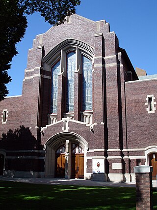
Knox United Church is a designated municipal heritage building at 838 Spadina Crescent East, in the Central Business District, of Saskatoon, Saskatchewan, Canada.


