"Climbing" of Gallatin Peak in 1922 by the Triangulation party of William M. Scaife.
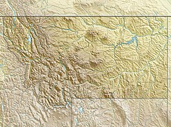
The Spanish Peaks, avg el. 8,441 feet (2,573m),[1] is a mountain range between Bozeman, Montana and Ennis, Montana in Gallatin and Madison County, Montana. It is a sub-range of the much larger Madison Range, itself a sub-range of the Rocky Mountains. The hydrological divide of the range serves as the border between Gallatin and Madison County, Montana. The Spanish Peaks are made up of 1.6 billion year-old gneiss, making them the oldest peaks in the Madison Range, predating the rest of the range by 50-60 million years. Gallatin Peak, el. 11,015ft., is the highest peak in the group.
A mountain range or hill range is a series of mountains or hills ranged in a line and connected by high ground. A mountain system or mountain belt is a group of mountain ranges with similarity in form, structure, and alignment that have arisen from the same cause, usually an orogeny. Mountain ranges are formed by a variety of geological processes, but most of the significant ones on Earth are the result of plate tectonics. Mountain ranges are also found on many planetary mass objects in the Solar System and are likely a feature of most terrestrial planets.
Bozeman is a city in and the seat of Gallatin County, Montana, United States. Located in southwest Montana, the 2010 census put Bozeman's population at 37,280 and by 2016 the population rose to 45,250, making it the fourth largest city in Montana. It is the principal city of the Bozeman, MT Micropolitan Statistical Area, consisting of all of Gallatin County with a population of 97,304. It is the largest Micropolitan Statistical Area in Montana and is the third largest of all of Montana's statistical areas.
Ennis is a town in Madison County, Montana, United States, in the southwestern part of the state. The population was 838 at the 2010 census.
This page is based on this Wikipedia article Text is available under the CC BY-SA 4.0 license; additional terms may apply. Images, videos and audio are available under their respective licenses.
Related Research Articles
Big Sky is a census-designated place (CDP) in Gallatin and Madison counties in southwestern Montana. As of the 2010 census it had a population of 2,308. It is 45 miles (72 km) southwest of Bozeman. This unincorporated community straddles both counties, is not considered a town, and does not have a town government. The primary industry of the area is tourism.
The Absaroka Range is a sub-range of the Rocky Mountains in the United States. The range stretches about 150 mi (240 km) across the Montana-Wyoming border, and 75 miles at its widest, forming the eastern boundary of Yellowstone National Park along Paradise Valley (Montana), and the western side of the Bighorn Basin. The range borders the Beartooth Mountains to the north and the Wind River Range to the south. The northern edge of the range rests along I-90 and Livingston, Montana. The highest peak in the range is Francs Peak, located in Wyoming at 13,153 ft (4,009 m). There are 46 other peaks over 12,000 ft (3,700 m).
The Gallatin River is a tributary of the Missouri River, approximately 120 mi, in the U.S. states of Wyoming and Montana. It is one of three rivers, along with the Jefferson and Madison, that converge near Three Forks, Montana, to form the Missouri.
Mount Madison is a mountain in the Presidential Range of New Hampshire in the United States. It is named after the fourth U.S. President, James Madison.
The Medicine Bow Mountains are a mountain range in the Rocky Mountains that extend for 100-mile (160 km) from northern Colorado into southern Wyoming. The northern extent of this range is the sub-range the Snowy Range. From the northern end of Colorado's Never Summer Mountains, the Medicine Bow mountains extend north from Cameron Pass along the border between Larimer and Jackson counties in Colorado and northward into south central Wyoming. In Wyoming, the range sits west of Laramie, in Albany and Carbon counties to the route of the Union Pacific Railroad and U.S. Interstate 80. The mountains often serve as a symbol for the city of Laramie. The range is home to Snowy Range Ski Area.
Red Mountain may refer to:
Monte Fitz Roy is a mountain in Patagonia, on the border between Argentina and Chile. It is located in the Southern Patagonian Ice Field, near El Chaltén village and Viedma lake. It was first climbed in 1952 by French alpinists Lionel Terray and Guido Magnone.
Founded in 1899, Gallatin National Forest is located in south central Montana, United States. The forest comprises 1,819,515 acres (7,363.32 km2) and has portions of both the Absaroka-Beartooth and Lee Metcalf Wilderness areas within its boundaries. Gallatin National Forest borders Yellowstone National Park on the north and northwest and is part of the Greater Yellowstone Ecosystem, a region which encompasses almost 20,000,000 acres (81,000 km2). The forest is named after Albert Gallatin (1761–1849), U.S. Secretary of the Treasury and scholar of Native American languages and cultures.
The Gallatin Range is a mountain range of the Rocky Mountains, located in the U.S. states of Montana and Wyoming. It includes more than 10 mountains over 10,000 feet (3,000 m). The highest peak in the range is Electric Peak at 10,969 feet (3,343 m).
Mount Holmes is a prominent mountain peak in Yellowstone National Park. It is the tallest mountain in the Wyoming portion of the Gallatin Range. Mount Holmes is located in the northwestern part of the park and marks the southern terminus of the Gallatin Range. It is the source of Indian Creek, a tributary of the Gardner River.
The Madison Range is a mountain range located in the Rocky Mountains of Montana and Idaho in the United States. The range was named in honor of future President of the United States, then U.S. Secretary of State James Madison by Meriwether Lewis as the Lewis and Clark Expedition travelled through Montana in 1805. The range extends 80 miles (130 km) from West Yellowstone, Montana to Bozeman, Montana and is flanked by the Madison River on the west and the Gallatin River to the east. The highest point in the range is Hilgard Peak at 11,316 ft (3,449 m), a remote peak that wasn't climbed until 1948.
Snowshoe Peak is a mountain in the U.S. state of Montana. At 8,738 ft (2,663 m), it is the highest peak in the Cabinet Mountains of Northwestern Montana and Idaho.
Antler Peak, el. 10,063 feet (3,067 m) is a prominent mountain peak in the Gallatin Range in Yellowstone National Park. The peak was originally named Bell's Peak in honor of an Assistant Secretary of the Interior by either Philetus Norris, the second park superintendent or W.H.Holmes, a U.S. Geological Survey geologist in 1878. However, in 1885, Arnold Hague of the U.S. Geological Survey renamed the peak Antler Peak because of the numerous shed elk and deer antlers found on its slopes.
Mount Jackson el. 8,231 feet (2,509 m) is a mountain peak just north of the Madison River, in the Gallatin Range of Yellowstone National Park. Mount Jackson is named in honor of William Henry Jackson, chief photographer of the Hayden Geological Survey of 1871 and a member of several subsequent geological surveys in the park. Jackson's photographs are some of the earliest ever taken in Yellowstone. The name was suggested by a park naturalist in 1935 but not awarded until 1937 when Jackson, who was still living gave his approval. Jackson visited the park regularly until his death in 1942.
Purple Mountain el. 8,392 feet (2,558 m) is a mountain peak in the southern section of the Gallatin Range in Yellowstone National Park. The Purple Mountain Trail ascends to the summit from Madison Junction.
Sheep Mountain may refer to:
Fan Mountain, 'el. 10,312 feet (3,143 m) is a prominent peak in the Madison Range in Madison County, Montana in the Beaverhead National Forest. The peak is located along the western face of the Madison Range at the northern end of the range. It is due east of Ennis Lake and its prominence and isolation makes it easy to distinguish from Ennis in the Madison River valley.
Storm Castle, el. 7,165 feet (2,184 m) is a mountain peak in the Gallatin Range in Gallatin County, Montana. The peak is located in the Gallatin National Forest. Storm Castle is also known as Castle Peak or Castle Mountain. The peak is a popular 5-mile (8.0 km) round trip hike from the Storm Castle trailhead in the Gallatin Canyon.