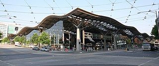
Southern Cross railway station is a major railway station in Docklands, Melbourne. It is on Spencer Street, between Collins and La Trobe Streets, at the western edge of the Melbourne central business district. The Docklands Stadium sports arena is 500 metres north-west of the station.

Docklands is an inner suburb of Melbourne, Victoria, Australia, 2 km (1.2 mi) west of the city's Central Business District (CBD). Its local government area is the City of Melbourne. At the 2016 Census, Docklands had a population of 10,964. Primarily a waterfront area centred on the banks of the Yarra River, it is bounded by Wurundjeri Way and the Charles Grimes Bridge to the east, CityLink to the west and Lorimer Street across the Yarra to the south.

This is a timeline of major events in the history of the city of Melbourne, Australia.

Hoddle Grid is the contemporary name given to the approximately 1-by-0.5-mile grid of streets that form the Melbourne central business district, Australia. Bounded by Flinders Street, Spring Street, La Trobe Street, and Spencer Street, it lies at an angle to the rest of the Melbourne suburban grid, and so is easily recognisable. It is named after the surveyor Robert Hoddle, who marked it out in 1837, establishing the first formal town plan. This grid of streets, laid out when there were only a few hundred settlers, became the nucleus for what is now Melbourne, a city of over five million people.

Bourke Street is one of the main streets in the Melbourne central business district and a core feature of the Hoddle Grid. It was traditionally the entertainment hub of inner-city Melbourne, and is now also a popular tourist destination and tram thoroughfare.

Collins Street is a major street in the centre of Melbourne, Victoria, Australia. It was laid out in the first survey of Melbourne, the original 1837 Hoddle Grid, and soon became the most desired address in the city. Collins Street was named after Lieutenant-Governor of Tasmania David Collins who led a group of settlers in establishing a short-lived settlement at Sorrento in 1803.

Flinders Street is a street in Melbourne, Victoria, Australia. Running roughly parallel to the Yarra River, Flinders Street forms the southern edge of the Hoddle Grid. It is exactly 1 mi (1.609 km) in length and one and a half chains in width. It is named for the explorer Matthew Flinders, erroneously credited with discovering Port Phillip at the time of its naming. It extends eastwards as far as Spring Street and the Treasury Gardens and westwards past Batman's Hill to the Melbourne Docklands. As the closest street to the river, Flinders Street serviced Melbourne's original river port. Customs House, now the site for Victoria's Immigration Museum, is on Flinders Street.

Elizabeth Street is one of the main streets in the central business district of Melbourne, Victoria, Australia, part of the Hoddle Grid laid out in 1837. It is presumed to have been named in honour of governor Richard Bourke's wife.

West Melbourne is an inner suburb of Melbourne, Australia, 2 km north-west of and adjacent to Melbourne's Central Business District. Its local government area is the City of Melbourne. At the 2016 census, West Melbourne had a population of 5,515.

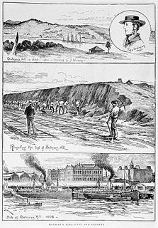
Batman's Hill in Melbourne, Australia was named for the Vandemonian adventurer and grazier John Batman. Now removed, the 18-metre-high hill was located to the south of today's Collins Street and Southern Cross railway station, and is the site of a steel marker the same height as the original hill.

La Trobe Street is a major street and thoroughfare in the city centre of Melbourne, Victoria, Australia. It runs roughly east–west and forms the northern boundary of Melbourne's central business district. The street was laid out as an extension of the original Hoddle Grid in 1839 and was named after Charles La Trobe. La Trobe Street extends from Victoria Street in the east to Harbour Esplanade in the west.

Yarra Park is part of the Melbourne Sports and Entertainment Precinct, the premier sporting precinct of Victoria, Australia. Located in Yarra Park is the Melbourne Cricket Ground (MCG) and numerous sporting fields and ovals, including the associated sporting complexes of Melbourne and Olympic Parks. The park and sporting facilities are located in the inner-suburb of East Melbourne. In the late 1850s, many of the earliest games of Australian rules football were played at Yarra Park, which was known at the time as the Richmond Paddock.

Russell Street is a main street and thoroughfare in the central business district of Melbourne, Victoria, Australia. It runs roughly north-south and was laid out as a core feature of the Hoddle Grid in 1837.

Victoria Street is one of the major thoroughfares of inner Melbourne, running east–west for over six kilometres between Munster Terrace in North Melbourne and the Yarra River. The road is known as Victoria Parade for over one-and-a-half kilometres of its length, distinguishable with a wide reservation and tramway down the middle.

Exhibition Street is a major street in the central business district of Melbourne, Australia. The street is named after the International Exhibition held at the Royal Exhibition Building in 1880, and was previously known as Stephen Street from 1837. The street runs roughly north-south and was laid out as part of the original Hoddle Grid.

King Street is a main road in the central business district of Melbourne, Australia. It is considered a key hub of Melbourne's nightlife and is home to many pubs, nightclubs, restaurants, and adult entertainment venues.

William Street is a major street in the central business district of Melbourne, Victoria, Australia. It runs roughly north–south from Flinders Street to Victoria Street, and was laid out in 1837 as part of the original Hoddle Grid. The street is located in-between King Street and Queen Street.

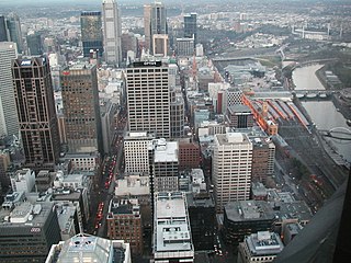
The Melbourne central business district is the city centre and main urban area of the city of Melbourne, Victoria, Australia, centred on the Hoddle Grid, the oldest part of the city laid out in 1837, and includes its fringes. It is not to be confused with the larger local government area of the City of Melbourne which includes this area and the inner suburbs around it.
The Wailing Wall is a section of brick retaining wall on the Flinders Street Extension, Melbourne, which is famous as the place where Wharf labourers who missed out on the daily work call would congregate.

No. 2 Goods Shed is a large railway freight shed in the former Spencer Street rail yards off Flinders Street Extension, Melbourne, Australia. It was constructed in 1889, originally called 'A Goods Shed', and at the time was the longest single building in Australia. Its address is at 733 Bourke Street, Docklands.


