
Puerto Rico, officially the Commonwealth of Puerto Rico, is a Caribbean island and unincorporated territory of the United States. It is located in the northeast Caribbean Sea, approximately 1,000 miles (1,600 km) southeast of Miami, Florida, between the Dominican Republic and the U.S. Virgin Islands, and includes the eponymous main island and several smaller islands, such as Mona, Culebra, and Vieques. It has roughly 3.2 million residents, and its capital and most populous city is San Juan. Spanish and English are the official languages of the executive branch of government, though Spanish predominates.

The geography of Puerto Rico consists of an archipelago located between the Caribbean Sea and the North Atlantic Ocean, east of the Dominican Republic or Hispaniola, west of the Virgin Islands and north of Venezuela. The main island of Puerto Rico is the smallest and most eastern of the Greater Antilles. With an area of 3,515 square miles (9,104 km2), it is the third largest island in the United States and the 82nd largest island in the world. Various smaller islands and cays, including Vieques, Culebra, Mona, Desecheo, and Caja de Muertos comprise the remainder of the archipelago with only Culebra and Vieques being inhabited year-round. Mona is uninhabited through large parts of the year except for employees of the Puerto Rico Department of Natural Resources.

San Juan is the capital city and most-populous municipality in the Commonwealth of Puerto Rico, an unincorporated territory of the United States. As of the 2010 census, it is the 46th-largest city under the jurisdiction of the United States, with a population of 395,326. San Juan was founded by Spanish colonists in 1521, who called it Ciudad de Puerto Rico.

Dr. Agustín Stahl was a Puerto Rican medical doctor and scientist with diverse interests in the fields of ethnology, botany, and zoology. He advocated Puerto Rico's independence from Spain.

Cerro de Punta or just Cerro Punta is the highest peak in Puerto Rico, rising to 1,338 meters (4,390 ft) above sea level. The mountain is part of the Cordillera Central and is located in the municipality of Ponce.

Cordillera Central, is the main mountain range in Puerto Rico. The range crosses the island from west to east and divides it into its northern and southern coastal plains. The Cordillera Central runs eastward from the municipality of Maricao in the west to Aibonito in the central eastern region, and on to the Caribbean in the southeast through the Sierra de Cayey. The Central Mountain Range consists of the Cordillera Central proper and numerous subranges, foothills and ridges that extend throughout the island. Cerro de Punta is both the highest peak of the Cordillera Central and the highest point in Puerto Rico. The Sierra de Luquillo, where El Yunque is located, is sometimes included as a subrange or eastward extension of the Cordillera Central.

Thespesia grandiflora is a tree in the family Malvaceae of the rosids clade. Its common name is maga. This tree is widely distributed throughout Puerto Rico where it is endemic. Although originally endemic to the humid mountains of limestone in the western and north-central portions of the Island, today it grows everywhere in Puerto Rico due to its extensive cultivation. It is also grown as an ornamental tree in Florida, Hawaii, Honduras and in various Caribbean islands. The maga is mostly used as an ornamental plant, but like the related Thespesia populnea its wood is also valued for its durable timber. The flower was declared the national symbol of Puerto Rico on August 7, 2019.
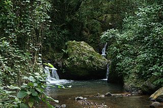
The Guánica State Forest, popularly known as the Guánica Dry Forest is a subtropical dry forest located in southwest Puerto Rico. The area was designated as a forest reserve in 1919 and a United Nations Biosphere Reserve in 1981. It is considered the best preserved subtropical dry forest and the best example of dry forest in the Caribbean.

The San Juan Botanical Garden, officially known as the Botanical Garden of the University of Puerto Rico, is located in the Caribbean city of San Juan, capital of Puerto Rico. This lush 300-acre (1.2 km2) “urban garden” of native and exotic flora serves as a laboratory for the study, conservation and enrichment of plants, trees, flowers, grasses and many other plants. Seventy-five acres are landscaped and open to the general public as well as researchers.

Laguna Tortuguero Natural Reserve is a natural reservoir located between the municipalities of Vega Baja and Manatí in Puerto Rico.

The economy of Puerto Rico is classified as a high income economy by the World Bank and as the most competitive economy in Latin America by the World Economic Forum. The main drivers of Puerto Rico's economy are manufacturing, primarily pharmaceuticals, textiles, petrochemicals, and electronics; followed by the service industry, notably finance, insurance, real estate, and tourism. The geography of Puerto Rico and its political status are both determining factors on its economic prosperity, primarily due to its relatively small size as an island; its lack of natural resources used to produce raw materials, and, consequently, its dependence on imports; as well as its relationship with the United States federal government, which controls its foreign policies while exerting trading restrictions, particularly in its shipping industry.

The Jewish immigration to Puerto Rico began in the 15th century with the arrival of the anusim who accompanied Christopher Columbus on his second voyage. An open Jewish community did not flourish in the colony because Judaism was prohibited by the Spanish Inquisition. However, many migrated to mountainous parts of the island, far from the central power of San Juan, and continued to self-identify as Jews and practice Crypto-Judaism.
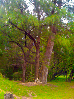
Maricao State Forest is a state forest located in the eastern Cordillera Central mountains of Puerto Rico. It is commonly known as Monte del Estado due to the fact that it was one of the first forest reserves in Puerto Rico to be designated a state forest in its official name. With an area of 10,803 acres (43.72 km2), the Maricao State Forest is the largest of the 20 forestry units of the Puerto Rico state forest system.

Café Rico is a Puerto Rican corporation that manufactures coffee branded by the same name. The company's headquarters are located at Avenida Las Americas/Route 163 and Calle Comercio/Route 133 in Barrio San Antón in the city of Ponce, Puerto Rico. The company used to be called Cooperativa de Cafeteros.
Piñones State Forest,, and named after the Casuarina, locally called Piñones, is a timberland forest near one of the longest beaches in Puerto Rico. It is located in Torrecilla Baja barrio in the municipality of Loíza. It is a tourist attraction and is managed by the Puerto Rico Department of Natural and Environmental Resources.

The Puerto Rico Electric Power Authority was an electric power company owned by the Commonwealth of Puerto Rico responsible for electricity generation, power distribution, and power transmission on the island. PREPA was the only entity authorized to conduct such business in Puerto Rico, making it a government monopoly, until on January 22, 2018, former governor of Puerto Rico, Ricardo Rossello, announced that all assets of the company will be sold in a general privatization of PREPA.
José Ernesto "Pichy" Torres Zamora is a Puerto Rican politician and former Secretary General of the New Progressive Party (PNP). He was a member of the Puerto Rico House of Representatives from June 10, 2010, when he replaced Iris Miriam Ruíz, until 2013. He won a seat in the PR House of Representatives in 2016 and currently he serves as the Speaker Pro Tempore of the Puerto Rico House of Representatives.

Cannabis in Puerto Rico is illegal for recreational use. Legislation to ban cannabis was passed in 1932, and legislation to legalize medical use was passed in 2017. Although the medical use of cannabis is permitted, smoking it is prohibited.
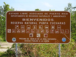
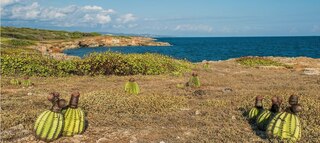
Reserva Natural Punta Cucharas is a nature reserve in Barrio Canas, Ponce, Puerto Rico. It consists of both a land area component as well as an offshore marine area. The land component has an area of 698 cuerdas while the marine component has an expanse of 3,516 cuerdas, for a total area of 4,214 cuerdas. The Reserve consists of mangrove ecosystems, coastal sand dunes, a saline lagoon known as Laguna Las Salinas, open water, and a century-old local community. The lagoon occupies and area of 347,898 m2 Ecological protection is managed and enforced by the Puerto Rico Department of Natural and Environmental Resources. Eight activities are allowed at the Reserve: scuba diving, boating, fishing, hiking, sun bathing, photography, bird watching and canoeing. Activities prohibited are: Camping, crabbing/trapping, horseback riding, water crafting, and hunting. Pets, ATVs, and fireplaces are also prohibited.

Vega State Forest is a state forest of Puerto Rico located in the municipalities of Vega Alta and Vega Baja. The subtropical moist forest is located in the northern coast of Puerto Rico in the middle of the karst zone known as the Carso Norteño, and it contains features typical of such geography such as sinkholes, caves and mogotes. It was designated a nature reserve in 1952 and it is fully protected by the Puerto Rico Forest laws of 1975. The forest has a total area of 1,150 acres divided into six forest units throughout the municipalities of Vega Alta and Vega Baja.