
Oxfordshire is a ceremonial county in South East England. The county is bordered by Northamptonshire and Warwickshire to the north, Buckinghamshire to the east, Berkshire to the south, and Wiltshire and Gloucestershire to the west. The city of Oxford is the largest settlement and county town.

The Isle of Dogs Pumping Station, nicknamed the Temple of Storms, is a pumping station located on the Isle of Dogs, London. It was designed by John Outram under commission from Edward Hollamby of the London Docklands Development Corporation and completed in 1988. It removes excess rainwater collected on the development's Enterprise Zone and overflow from the nearby Manchester Road sewers. The station was granted grade II* heritage status by Historic England in 2017 during a campaign for greater representation of post-modern architecture on the register.

Faringdon is a historic market town in the Vale of White Horse, Oxfordshire, England, 18 miles (29 km) south-west of Oxford, 10 miles (16 km) north-west of Wantage and 12 miles (19 km) east-north-east of Swindon. Its views extend to the River Thames in the north and the highest ground visible is on the Ridgeway in the south. Faringdon was Berkshire's westernmost town until the 1974 boundary changes transferred its administration to Oxfordshire. The civil parish is formally known as Great Faringdon, to distinguish it from Little Faringdon in West Oxfordshire. The 2011 Census gave a population of 7,121; it was estimated at 7,992 in 2019. On 1 February 2004, Faringdon became the first place in south-east England to be awarded Fairtrade Town status.

Culham is a village and civil parish in a bend of the River Thames, 1 mile (1.6 km) south of Abingdon in Oxfordshire. The parish includes Culham Science Centre and Europa School UK. The parish is bounded by the Thames to the north, west and south, and by present and former field boundaries to the east. It is low-lying and fairly flat, rising from the Thames floodplain in the south to a north-facing escarpment in the north up to 260 feet (80 m) above sea level. The 2011 Census recorded its population as 453.
Shiplake consists of three settlements: Shiplake, Shiplake Cross and Lower Shiplake. Together these villages form a civil parish situated beside the River Thames 2 miles (3 km) south of Henley-on-Thames, Oxfordshire, England. The river forms the parish boundary to the east and south, and also the county boundary between Oxfordshire and Berkshire. The villages have two discrete centres separated by agricultural land. The 2011 Census records the parish population as 1,954 and containing 679 homes. The A4155 main road linking Henley with Reading, Berkshire passes through the parish.

Nettlebed is a village and civil parish in Oxfordshire in the Chiltern Hills about 4+1⁄2 miles (7 km) north-west of Henley-on-Thames and 6 miles (10 km) south-east of Wallingford. The parish includes the hamlet of Crocker End, about 1⁄2 mile (800 m) east of the village. The 2011 Census recorded a parish population of 727.

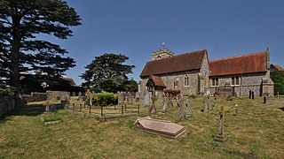
South Stoke is a village and civil parish on an east bank of the Thames, about 1.5 miles (2.4 km) north of Goring-on-Thames in South Oxfordshire. It includes less than 1 mile (1.6 km) to its north the hamlet and manor house of Littlestoke.

Lyddington Bede House is a historic house in Rutland, England, owned and opened to the public by English Heritage. The existing Grade I listed building is a part of a former palace of the Bishops of Lincoln, later used as an almshouse. It is next to St Andrew's Church in the village of Lyddington. The watch tower or gazebo is separately listed as Grade I and the boundary walls are Grade II. The site is a scheduled monument.

Moulsford is a village and civil parish in South Oxfordshire. Before 1974, it was in the county of Berkshire, in Wallingford Rural District, but following the Berkshire boundary changes of that year it became a part of Oxfordshire. Moulsford is on the A329, by the River Thames, just north of Streatley and south of Wallingford. The west of the parish is taken up by the foothills of the Berkshire Downs, including the Moulsford Downs. Moulsford Bottom and Kingstanding Hill are traditionally associated with King Alfred and the Battle of Ashdown.

Longworth is a village and civil parish in the Vale of White Horse, England. Historically within the north-west projection of Berkshire, boundary changes transferred it to Oxfordshire in 1974. The village is between Faringdon, 7 miles (11 km) to the west, and Oxford, 9 miles (14 km) to the northeast. The 2021 Census recorded the parish's population as 543.

Harwell is a village and civil parish in the Vale of White Horse about 2 miles (3 km) west of Didcot, 6 miles (10 km) east of Wantage and 13 miles (21 km) south of Oxford, England. The parish measures about 3.5 miles (6 km) north – south, and almost 2 miles (3 km) east – west at its widest point. In 1923 its area was 2,521 acres (1,020 ha). Historically in Berkshire, it has been administered as part of Oxfordshire since the 1974 boundary changes. The parish includes part of Harwell Science and Innovation Campus in the southwest. The 2011 census recorded the parish's population as 2,349.
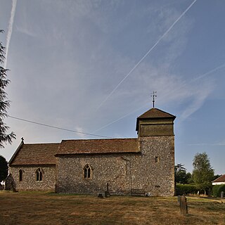
Nuffield is a village and civil parish in the Chiltern Hills in South Oxfordshire, England, just over 4 miles (6 km) east of Wallingford. The 2011 Census recorded the parish population as 939.

Hinton Waldrist is a village and civil parish in the Vale of White Horse, England. It was part of Berkshire until the 1974 boundary changes transferred it to Oxfordshire. The village is between Oxford and Faringdon, 9 miles (14 km) southwest of Oxford. The parish includes the hamlet of Duxford. The 2011 Census recorded the parish's population as 328.

High Pavement is a street in Nottingham in Nottinghamshire, England. It is one of the earliest streets in the city, and most of its buildings are listed.

John Outram is a British architect. He established a practice in London in 1974 and produced a series of buildings in which polychromy and Classical allusions were well to the fore. Among his works are the temple-like Storm Water Pumping Station, Isle of Dogs, London (1985–88), the New House at Wadhurst Park, Sussex (1978–86), the Judge Institute of Management Studies in Cambridge (1995), and the Computational Engineering Building, Rice University, Houston, Texas (1997).

Fair Mile Hospital was a lunatic asylum built in 1870 in the village of Cholsey, 2 miles (3 km) south of Wallingford and north of Moulsford. The asylum was built next to the River Thames between Wallingford and Reading, formerly in Berkshire but, following the boundary changes of 1974, now in Oxfordshire.
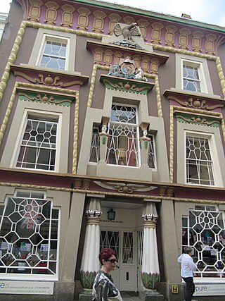
Egyptian Revival architecture in the British Isles is a survey of motifs derived from Ancient Egyptian sources occurring as an architectural style. Egyptian Revival architecture is comparatively rare in the British Isles. Obelisks start appearing in the 17th century, mainly as decorative features on buildings and by the 18th century they started to be used in some numbers as funerary or commemorative monuments. In the later 18th century, mausoleums started to be built based on pyramids, and sphinxes were used as decorative features associated with monuments or mounted on gate piers. The pylon, a doorway feature with spreading jambs which support a lintel, also started to be used and became popular with architects.

Walton Court was an office building on Station Avenue in Walton-on-Thames, in the Borough of Elmbridge, Surrey. It was constructed in 1961–62 to serve as the UK corporate headquarters of Birds Eye. It became a Grade II listed building in November 1995, but was demolished from 2019 to be replaced by a residential development.
The New House, Wadhurst Park, Wadhurst is a Postmodernist country house in East Sussex, England. It was commissioned by Hans Rausing and his wife, Märit, and designed by John Outram. Built between 1982 and 1986, the house was designated a Grade I listed building in 2020.
The Isle of Dogs Pumping Station, nicknamed the Temple of Storms, is a pumping station located on the Isle of Dogs, London. It was designed by John Outram under commission from Edward Hollamby of the London Docklands Development Corporation and completed in 1988. It removes excess rainwater collected on the development's Enterprise Zone and overflow from the nearby Manchester Road sewers. The station was granted grade II* heritage status by Historic England in 2017 during a campaign for greater representation of post-modern architecture on the register.

