
Valais, or Wallis, more formally the Canton of Valais, is one of the 26 cantons forming the Swiss Confederation. It is composed of thirteen districts and its capital and largest city is Sion. The flag of the canton is made of thirteen stars representing the districts, on a white-red background.
On 26 June 1964, Swiss Post introduced postal codes as the third country after Germany (1941) and the United States (1963).
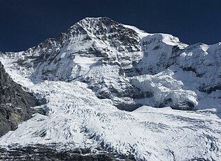
The Mönch at 4,110 metres (13,480 ft) is a mountain in the Bernese Alps, in Switzerland. Together with the Eiger and the Jungfrau, it forms a highly recognisable group of mountains, visible from far away.

The Gletscherhorn is a mountain of the Bernese Alps, located on the border between the Swiss cantons of Bern and Valais. It forms the eastern edge of the Lauterbrunnen Wall, south of the Jungfrau.

Romandy is the French-speaking part of western Switzerland. In 2018, about 2.1 million people, or 25.1% of the Swiss population, lived in Romandy. The majority of the romand population lives in the western part of the country, especially the Arc Lémanique region along Lake Geneva, connecting Geneva, Vaud and the Lower Valais.
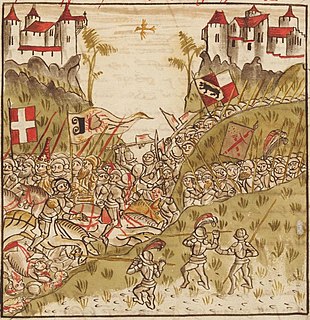
The Battle on the Planta, fought on 13 November 1475 around Conthey near Sion, Valais, Switzerland, was part of the Burgundian Wars.

The Tschingelhorn is a mountain of the Bernese Alps, located on the border between the Swiss cantons of Bern and Valais. The summit of the Klein Tschingelhorn on the west is the tripoint between the valleys of Kandertal, Lauterbrunnental and Lötschental. The main summit lies between the Lauterbrunnental and the Lötschental.

The Balmhorn is a mountain in the Bernese Alps in Switzerland. Its summit ridge lies on the border between the cantons of Berne and the Valais.

The Plaine Morte Glacier is a glacier located at an elevation of 2,750 m (9,020 ft), in the canton of Bern above Lenk and in the Valais above Crans-Montana in Switzerland. The ice field, which covers 7.88 square kilometres (3.04 sq mi), is located below the mountain of Wildstrubel in the Bernese Alps. Its largest tongue is also called in German Rezligletscher or Rätzligletscher.

The Ebnefluh, also known as the Äbeni Flue and the Ebenefluh, is a mountain of the Bernese Alps, located on the border between the Swiss cantons of Bern and Valais. It lies towards the eastern end of the Lauterbrunnen Wall.

The Hockenhorn is a mountain of the Bernese Alps, located on the border between the Swiss cantons of Bern and Valais. Its summit is 3,293 metres high and lies between the upper Kandertal and the Lötschental. On its southern (Valais) side lies a glacier named Milibachgletscher.

The Altels is a mountain of the Bernese Alps, located on the border between the Swiss cantons of Bern and Valais. It is situated in the Balmhorn massif, approximately halfway between Kandersteg and Leukerbad.

The Steghorn is a mountain of the Bernese Alps, located on the border between the Swiss cantons of Bern and Valais. It lies between the Engstligenalp (Bernese Oberland and the Gemmi Pass. The Steghorn belongs to the massif of the Wildstrubel.

Pizzo Rotondo is a mountain in the Lepontine Alps. At 3,190 metres above sea level, it is the highest mountain lying on the border between the cantons of Ticino and Valais, as well as the highest summit of the Lepontine Alps lying between Nufenen Pass and Lukmanier Pass.

The Oberaarhorn is a mountain of the Bernese Alps, located on the border between the Swiss cantons of Valais and Bern. Its summit is the tripoint between the basins of the Fiesch (Valais), Unteraar and Oberaar Glacier (Bern).

The Mittaghorn is a mountain of the Bernese Alps, located on the border between the cantons of Bern and Valais. It is situated in the middle of the Lauterbrunnen Wall.
The Eggstock, is a minor prominence of the Uri Alps, forming the northern pillar of the Dammastock on the border between the cantons of Valais and Uri. The tripoint between the cantons of Bern, Valais and Uri is located 600 m west of the summit.

The Oberaarjoch is a high mountain pass across the eastern Bernese Alps, connecting the Fiescher Glacier in the canton of Valais to the Oberaar Glacier in the canton Bern. The pass is located between the Oberaarhorn on the north and the Oberaarrothorn on the south. Above the col, on the Valais side, lies the Oberaarjoch Hut.

The Raron affair was a 15th-century rebellion in the Valais against the power of a local noble family, the Raron family. The rebellion brought several cantons of the Swiss Confederation into conflict with each other and threatened a civil war in the Confederation. While Bern was initially successful, they were eventually forced to surrender most of their gains.

Felsenburg Castle is a ruined castle in the municipality of Kandergrund of the Canton of Bern in Switzerland. It is a Swiss heritage site of national significance.

