Spivey's Corner, North Carolina

Last updated

Spiveys Corner, North Carolina
CDP
MuddySC.JPG
The National Hollerin' Contest
USA North Carolina location map.svg
Red pog.svg
Spiveys Corner
Location within the state of North Carolina
Coordinates: 35°11′53″N78°28′57″W / 35.19806°N 78.48250°W / 35.19806; -78.48250
Country United States
State North Carolina
County Sampson
Area
[1]
  Total7.77 sq mi (20.13 km2)
  Land7.77 sq mi (20.13 km2)
  Water0.00 sq mi (0.00 km2)
Elevation
[2]
190 ft (60 m)
Population
 (2020)
  Total576
  Density74.12/sq mi (28.62/km2)
Time zone UTC-5 (Eastern (EST))
  Summer (DST) UTC-4 (EDT)
FIPS code 37-63920 [3]
GNIS feature ID2402887 [2]

Spivey's Corner is a census-designated place located in Sampson County, North Carolina, United States, at the intersection of U.S. Highway 13 and U.S. Highway 421. As of the 2020 census, the CDP had a total population of 576.

Contents

From 1969 to 2015, Spivey's Corner was the home of the National Hollerin' Contest. Contestants from the contest have appeared on Johnny Carson's The Tonight Show and the Late Show with David Letterman .

Geography

According to the United States Census Bureau, the CDP has a total area of 7.8 square miles (20 km2), all land.

Demographics

Historical population
CensusPop.Note
2020 576
U.S. Decennial Census [4]

As of the 2000 United States Census, [3] there were 448 people in the town, organized into 149 households and 119 families. The population density was 57.8 inhabitants per square mile (22.3/km2). There were 178 housing units at an average density of 23.0/sq mi (8.9/km2). The racial makeup of the CDP was 58.48% White, 37.95% African American, 0.22% Native American, 0.00% Asian, 0.00% Pacific Islander, 3.35% from other races, and 0.00% from two or more races. 5.58% of the population were Hispanic or Latino of any race.

There were 149 households, out of which 41.6% had children under the age of 18 living with them, 61.1% were married couples living together, 13.4% had a female householder with no husband present, and 20.1% were non-families. 14.1% of all households were made up of individuals, and 7.4% had someone living alone who was 65 years of age or older. The average household size was 3.01 and the average family size was 3.31.

In the CDP, the population was spread out, with 29.9% under the age of 18, 6.9% from 18 to 24, 33.9% from 25 to 44, 21.9% from 45 to 64, and 7.4% who were 65 years of age or older. The median age was 34 years. For every 100 females, there were 92.3 males. For every 100 females age 18 and over, there were 85.8 males.

The median income for a household in the CDP was $47,000, and the median income for a family was $48,542. Males had a median income of $36,250 versus $24,643 for females. The per capita income for the CDP was $16,371. 25.4% of the population and 21.1% of families were below the poverty line. Out of the total population, 32.2% of those under the age of 18 and 23.8% of those 65 and older were living below the poverty line.

Culture

Hollerin Road street sign in Spivey's Corner Spiveys-hollerinroad.jpg
Hollerin Road street sign in Spivey's Corner

The National Hollerin' Contest, first held in 1969, was an annual competition held in Spivey's Corner. It continued for nearly 50 years, before ending in 2015.

The contest, held on the first Saturday in September, was inaugurated in order to revive the almost-lost art of "hollerin", a sophisticated vocal tradition that served as a means of long-distance communication between individuals as well as an amusing form of entertainment, before the widespread adoption of the telephone. From 1969 until 2012, the contest was held on the third Saturday of June, with it changing to September beginning in 2013. The final contest was held in 2015.[ citation needed ]

Related Research Articles

<span class="mw-page-title-main">Theodore, Alabama</span> Census-designated place in Alabama, United States

Theodore is an unincorporated area and census-designated place (CDP) in Mobile County, Alabama, United States. The population was 6,270 at the 2020 census. It is a part of the Mobile metropolitan area. Prior to 1900 this area was known as "Clements", but it is now named for William Theodore Hieronymous, a sawmill operator and postmaster.

Kaibab is an unincorporated community and census-designated place (CDP) in Mohave County, Arizona, United States. It is within the Kaibab Indian Reservation. The population of the CDP was 140 at the 2020 census.

<span class="mw-page-title-main">Three Lakes, Florida</span> Census-designated place in Florida, United States

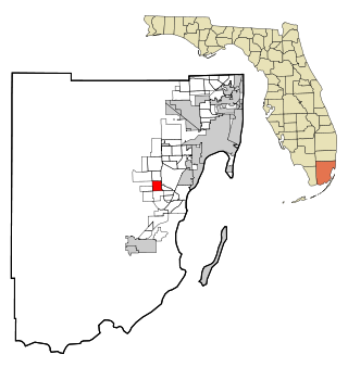
Three Lakes is a census-designated place (CDP) in Miami-Dade County, Florida, United States. The population was 16,540 at the 2020 census, up from 15,047 in 2010. Its name comes from the planned community of Three Lakes, which is located inside Three Lakes CDP boundaries.

<span class="mw-page-title-main">Loughman, Florida</span> Census-designated place in Florida, United States

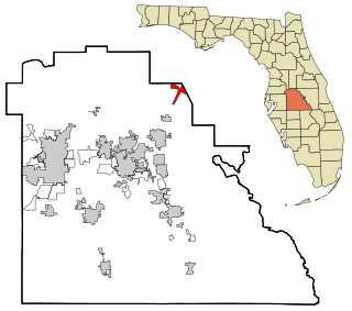
Loughman (LOFF-mǝn) is a census-designated place (CDP) in the northeast corner of Polk County, Florida, United States, near the Osceola county line. The population was 1,385 at the 2000 census. It is part of the Lakeland–Winter Haven Metropolitan Statistical Area. This area has grown rapidly since 2000 due, in large part, to its proximity to Walt Disney World and the Orlando, Florida area.

<span class="mw-page-title-main">Spivey, Kansas</span> City in Kingman County, Kansas

Spivey is a city in Kingman County, Kansas, United States. As of the 2020 census, the population of the city was 61.

<span class="mw-page-title-main">Wilson-Conococheague, Maryland</span> CDP in Maryland, United States

Wilson-Conococheague is a census-designated place (CDP) in Washington County, Maryland, United States. The population was 2,262 at the 2020 census.

<span class="mw-page-title-main">Millers Falls, Massachusetts</span> Census-designated place in Massachusetts, United States

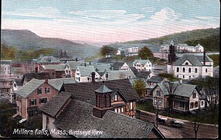
Millers Falls is a census-designated place (CDP) in the towns of Montague and Erving in Franklin County, Massachusetts, United States. The population was 1,139 at the 2010 census. It is part of the Springfield, Massachusetts metropolitan statistical area.

<span class="mw-page-title-main">Allenwood, New Jersey</span> Populated place in Monmouth County, New Jersey, US

Allenwood is an unincorporated community and census-designated place (CDP) located within Wall Township, in Monmouth County, in the U.S. state of New Jersey. As of the 2010 United States Census, the CDP's population was 925.

<span class="mw-page-title-main">Crandon Lakes, New Jersey</span> Populated place in Sussex County, New Jersey, US

Crandon Lakes is an unincorporated community and census-designated place (CDP) split between Hampton Township and Stillwater Township, in Sussex County, in the U.S. state of New Jersey. As of the 2010 United States Census, the CDP's population was 1,178, of which 682 were in Hampton Township and 496 in Stillwater Township.

<span class="mw-page-title-main">Myers Corner, New York</span> Census-designated place in New York, United States

Myers Corner is a hamlet and census-designated place (CDP) in the town of Wappinger, Dutchess County, New York, United States. The population was 6,790 at the 2010 census. It is part of the Poughkeepsie–Newburgh–Middletown, NY Metropolitan Statistical Area as well as the larger New York–Newark–Bridgeport, NY-NJ-CT-PA Combined Statistical Area.

<span class="mw-page-title-main">Scotchtown, New York</span> Hamlet and CDP in New York, United States

Scotchtown is a hamlet in the Town of Wallkill, in Orange County, New York, United States. The population was 10,578 at the 2020 census. It has the ZIP Code 10941. The hamlet is located east of the City of Middletown. It is part of the Poughkeepsie–Newburgh–Middletown, NY Metropolitan Statistical Area as well as the larger New York–Newark–Bridgeport, NY-NJ-CT-PA Combined Statistical Area.

<span class="mw-page-title-main">Scotts Corners, New York</span> CDP in New York, United States

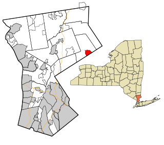
Scotts Corners is a hamlet located in the town of Pound Ridge in Westchester County, New York, United States. As of the 2010 census, the CDP population was 711, making Scotts Corners Westchester County's smallest census-recognized area.

Sams Corner is a census-designated place (CDP) in Mayes County, Oklahoma, United States. The population was 137 at the 2010 census, compared to 126 at the 2000 census.

<span class="mw-page-title-main">Narcissa, Oklahoma</span> CDP in Oklahoma, United States

Narcissa is a census-designated place (CDP) in Ottawa County, Oklahoma, United States. The population was 100 at the 2000 census. Narcissa is part of the Joplin, Missouri metropolitan area.

<span class="mw-page-title-main">Four Corners, Oregon</span> Unincorporated community in the state of Oregon, United States

Four Corners is a census-designated place (CDP) in Marion County, Oregon, United States, just outside the city limits of Salem but within the city's urban growth boundary. It is part of the Salem Metropolitan Statistical Area. The population of the CDP was 16,740 at the 2020 census. It is named after the intersection of State Street and Lancaster Drive.

<span class="mw-page-title-main">Belmont, Pennsylvania</span> Census-designated place in Pennsylvania, United States

Belmont is an unincorporated community and census-designated place (CDP) in Cambria County, Pennsylvania, United States. The population was 2,784 at the 2010 census.

<span class="mw-page-title-main">Eyers Grove, Pennsylvania</span> Census-designated place in Pennsylvania, United States

Eyers Grove is a census-designated place in Columbia County, Pennsylvania, United States. It is part of Northeastern Pennsylvania. The population was 102 at the 2020 census. It is part of the Bloomsburg-Berwick micropolitan area.

Forestville is a census-designated place (CDP) in Schuylkill County, Pennsylvania, United States. The population was 431 at the 2000 census.

<span class="mw-page-title-main">North Spearfish, South Dakota</span> Census-designated place in South Dakota, United States

North Spearfish is a census-designated place (CDP) in Lawrence County, South Dakota, United States. The population was 2,366 at the 2020 census.

<span class="mw-page-title-main">Lakeview, Washington</span> Census-designated place in Washington, United States

Lakeview is a census-designated place (CDP) in Grant County, Washington, United States. The population was 915 at the 2010 census, up from 797 at the 2000 census. The community is referred to as Lakeview Park on topographic maps and by locals.

References

  1. "ArcGIS REST Services Directory". United States Census Bureau. Retrieved September 20, 2022.
  2. 1 2 U.S. Geological Survey Geographic Names Information System: Spivey's Corner, North Carolina
  3. 1 2 "U.S. Census website". United States Census Bureau . Retrieved January 31, 2008.
  4. "Census of Population and Housing". Census.gov. Retrieved June 4, 2016.