Mansfield is a town in Tolland County, Connecticut, United States. The town is part of the Capitol Planning Region. The population was 25,892 at the 2020 census.

Gales Ferry is a census-designated place and village in the town of Ledyard, Connecticut, United States. It is located along the eastern bank of the Thames River. The community developed as a result of having a ferry to Uncasville located at this site, and from which the village was named. Gales Ferry was listed as a census-designated place for the 2010 Census, with a population of 1,162.
The Quaker Hill Historic District encompasses the center a mainly residential village in northeastern Waterford, Connecticut. Running in a mostly linear fashion along Old Norwich Road between Connecticut Route 32 and Richard Grove Road, the area first grew as a settlement of religious non-conformists in the 17th century, developed in the 19th century as a small industrial village, and became more suburban in character in the 20th century. Its architecture is reflective of these changes, and it was listed on the National Register of Historic Places in 2002.
The Sterling Hill Historic District encompasses a well-preserved early 19th-century rural village center on western edge of the town of Sterling, Connecticut. Centered at the junction of Plainfield Pike and Sterling Hill Road, it consists of a cluster of 19th and early 19th-century houses, and a church. Unlike other period villages, it has largely been unaffected by later development. It was listed on the National Register of Historic Places in 1986.

The Thompson Hill Historic District encompasses the historic village center of Thompson, Connecticut. The district covers 550 acres (220 ha), whose central focus is the Thompson Center Green, laid out when the town was established in 1735. Thompson Hill was the town's early civic and economic center, later supplanted by industrial villages, and retains well-preserved architecture from the 18th and early 19th centuries. The district was listed on the National Register of Historic Places in 1987.
The Mansfield Hollow Historic District encompasses the remnants of a modest 19th-century industrial village on Mansfield Hollow Road in Mansfield, Connecticut. Originally industrialized with saw and grist mills, a silk mill was added in 1838, when its most significant growth began. The surviving stone mill was built in 1882, and there are a number of nearby houses dating to the industrial period. The district was listed on the National Register of Historic Places in 1979.

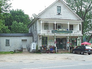
The South Britain Historic District encompasses the core of the unincorporated village of South Britain in Southbury, Connecticut, United States. The village arose in the 18th century as an industrial center serving the surrounding agricultural community, powered by the Pomperaug River, and rivalled the town center of Southbury in importance. The district was listed on the National Register of Historic Places in 1987.

The Hotchkissville Historic District is a historic district in the town of Woodbury, Connecticut, United States that was listed on the National Register of Historic Places in 1995. The district encompasses most of the historic village of Hotchkissville, which is centered at the junction of Washington and Weekeepeemee roads. The village began as a dispersed rural agricultural community, but developed in the 19th century with the arrival of industry, primarily the manufacture of textiles. Despite this, the village has retained a significantly rural character, and includes a broad cross-section of 18th- and 19th-century architectural styles.

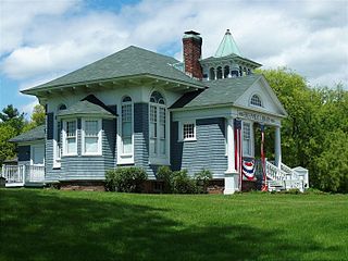
Goshen Historic District is a historic district encompassing the town center village of Goshen, Connecticut. Centered at the junction of Connecticut Routes 4 and 63, the village developed historically as a rural crossroads of two turnpikes, and has retained its rural character. It is dominated by residential architecture from the first half of the 19th century, and includes churches, a store, and the town's former 1895 town hall. It was listed on the National Register of Historic Places in 1982.
Marion is a neighborhood in the town of Southington, Connecticut, United States. It is generally the area in the vicinity of the intersection of Route 322 and Marion Avenue, just north of the Cheshire town line.

The New Preston Hill Historic District encompasses a small rural 19th-century village center in the New Preston area of the town of Washington, in Litchfield County, Connecticut. Settled in the late 18th century, it is distinctive for its examples of stone architecture, include a rare Federal period stone church. The district, located at the junction of New Preston Road with Gunn Hill and Findlay Roads, was listed on the National Register of Historic Places in 1985.
The Andover Center Historic District encompasses the historic town center of Andover, Connecticut. Centered on the junction of Hebron Road with Center Street and Cider Mill Road, the district includes houses dating to the town's early history, civic buildings including a library and former town hall, and the town's first cemetery. The district was listed on the National Register of Historic Places in 2003.
The Somers Historic District encompasses the historic civic and social center of the town of Somers, Connecticut. It stretches along Main Street, with extensions along Springfield Road and Battle Street, and includes a significant number of vernacular Federal and Greek Revival houses. It includes the town's early churches, as well as important civic buildings, including the town hall and library. The district was listed on the National Register of Historic Places in 1982.
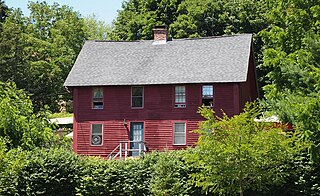
The Eleazer Williams House is a historic house in Mansfield Center, Connecticut, United States. It is located on Storrs Road near the southeast corner of the junction with Dodd Road. Completed in 1710, it was the home of the town's first minister and has a well-preserved chronology of alteration, illustrating changing building practices over the 18th century. The house was listed on the National Register of Historic Places in 1971 and is included within the Mansfield Center Historic District.
The Mansfield Center Historic District encompasses the historic early village center of Mansfield, Connecticut. First settled about 1692, it is one of the oldest settlements in Tolland County, and retains a strong sense of 18th century colonial layout. It extends along Storrs Street extending from Chaffeeville Road in the north to Centre Street in the south, and was listed on the National Register of Historic Places in 1972.

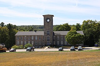
The University of Connecticut Historic District is a 105-acre (42 ha) historic district including the historic campus of the Connecticut Agricultural School, now the main campus of the University of Connecticut (UConn) in Storrs, Connecticut.
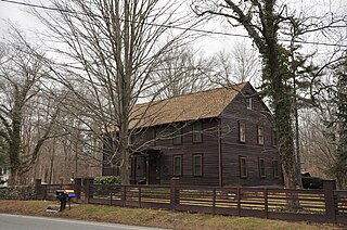
Edwin Fitch was an architect and builder in Connecticut.

The Metro South Historic District encompasses a portion of the downtown area of Middletown, Connecticut. Extending south from Main and College Streets for two blocks, this area was developed in the 19th century, and contains a diversity of well-preserved architecture from that period, some with association to locally important individuals. It was listed on the National Register of Historic Places in 1980.

The Putney Village Historic District encompasses most of the main village and town center of Putney, Vermont. Settled in the 1760s, the village saw its major growth in the late 18th and early 19th century, and includes a cohesive collection with Federal and Greek Revival buildings, with a more modest number of important later additions, including the Italianate town hall. The district was listed on the National Register of Historic Places in 1986.

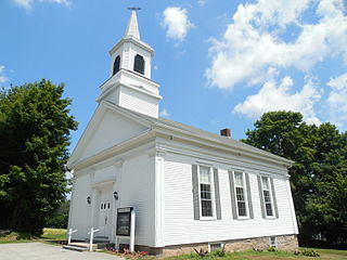
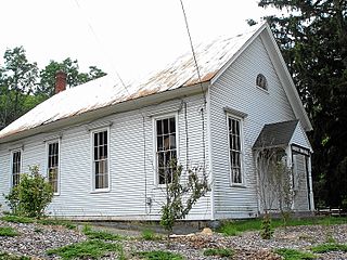
The Hastings Hill Historic District encompasses a rural crossroads settlement of the early 19th century at the junction of Spruce Street, Hill Street, and Russell Avenue in Suffield, Connecticut. The area includes well-preserved examples of 18th and 18th-century domestic architecture, as well as the 1842 First Baptist Church and a district schoolhouse. It was listed on the National Register of Historic Places in 1979.


