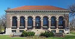
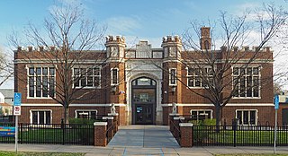
Although one of Saint Paul's smaller library branches at 10,590 square feet (984m2), the St. Anthony Park Branch circulated 265,776 items in 2005, making it the third-busiest branch in the city. The on-site collection numbered 55,175 items that same year. The branch is open 44 hours per week, Monday to Saturday.
The St. Anthony Park Branch is unique in having its own community advocacy group, the St. Anthony Park Library Association (SAPLA), in addition to the overall Friends of the St. Paul Public Library. The annual St. Anthony Park Arts Festival began on the library's front lawn and now sprawls for more than a block. During the festival, which is the first Saturday in June, the library holds a very large used book sale.
Saint Paul is the capital of the U.S. state of Minnesota and the county seat of Ramsey County. Situated on high bluffs overlooking a bend in the Mississippi River, Saint Paul is a regional business hub and the center of Minnesota's government. The Minnesota State Capitol and the state government offices all sit on a hill close to the city's downtown district. One of the oldest cities in Minnesota, Saint Paul has several historic neighborhoods and landmarks, such as the Summit Avenue Neighborhood, the James J. Hill House, and the Cathedral of Saint Paul. Like the adjacent city of Minneapolis, Saint Paul is known for its cold, snowy winters and humid summers.
The Boston Public Library is a municipal public library system in Boston, Massachusetts, founded in 1848. The Boston Public Library is also Massachusetts' Library for the Commonwealth, meaning all adult residents of the state are entitled to borrowing and research privileges, and the library receives state funding. The Boston Public Library contains approximately 24 million items, making it the third-largest public library in the United States behind the federal Library of Congress and New York Public Library, which is also privately endowed. In 2014, the library held more than 10,000 programs, all free to the public, and lent 3.7 million materials.
Minneapolis–Saint Paul is a metropolitan area in the Upper Midwestern United States centered around the confluence of the Mississippi, Minnesota and St. Croix rivers in the U.S. state of Minnesota. It is commonly known as the Twin Cities after the area's two largest cities, Minneapolis and Saint Paul. Minnesotans often refer to the two together simply as "the cities". The area is Minnesota's economic, cultural, and political center.
Minneapolis, officially the City of Minneapolis, is a city in and the county seat of Hennepin County, Minnesota, United States. With a population of 429,954, it is the state's most populous city as of the 2020 census. It occupies both banks of the Mississippi River and adjoins Saint Paul, the state capital of Minnesota. Minneapolis, Saint Paul, and the surrounding area are collectively known as the Twin Cities, a metropolitan area with 3.69 million residents. Minneapolis is built on an artesian aquifer on flat terrain, and is known for cold, snowy winters and hot, humid summers. Nicknamed the "City of Lakes", Minneapolis is abundant in water, with thirteen lakes, wetlands, the Mississippi River, creeks, and waterfalls. The city's public park system is connected by the Grand Rounds National Scenic Byway.
Northeast is a defined community in the U.S. city of Minneapolis that is composed of 13 smaller neighborhoods whose street addresses end in "NE". Unofficially it also includes the neighborhoods of the University community which have "NE" addresses, and the entirety of the Old Saint Anthony business district, which sits on the dividing line of "NE" and "SE" addresses. In the wider community, this business district, which is the oldest settlement in the city, is often identified as the heart of Northeast, in part because it lies across the Mississippi River from Downtown Minneapolis. Northeast is sometimes referred to as "Nordeast", reflecting the history of northern and eastern European immigrants and their language influence.
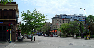
Saint Anthony Park is a neighborhood in northwest Saint Paul, Minnesota. It is adjacent to the University of Minnesota's St. Paul Campus, bordering Prospect Park, Minneapolis on the west, the Minnesota State Fairgrounds on the east, and the suburbs of Falcon Heights and Lauderdale to the north.
Saint Paul, Minnesota contains many educational institutions from grade school to high school, college and beyond. A number of educational "firsts" have happened in Saint Paul. Hamline University, the first and oldest college in Minnesota, was founded in Saint Paul in 1854. In 1991, Minnesota became the first state in the United States to pass legislation allowing the existence of charter schools. The following year, the first charter school in the nation, City Academy High School, was established in Saint Paul. The oldest library in Minnesota, the Minnesota State Law Library, was opened in 1849.
The Saint Paul Public Library is a library system serving the residents of Saint Paul, Minnesota, in the United States. The library system includes a Central Library, twelve branch locations, and a bookmobile. It is a member of the Metropolitan Library Service Agency, a consortium of eight Twin Cities library systems.
Minneapolis is the largest city by population in the U.S. state of Minnesota, and the county seat of Hennepin County. The origin and growth of the city was spurred by the proximity of Fort Snelling, the first major United States military presence in the area, and by its location on Saint Anthony Falls, which provided power for sawmills and flour mills.
Saint Paul, Minnesota, consists of 17 officially defined city districts or neighborhoods.
Riverview Branch Library is a branch of the Saint Paul Public Library serving the West Side neighborhood of Saint Paul, Minnesota, United States. It is a Carnegie library built in 1916. It was listed on the National Register of Historic Places in 1984 for having local significance in the themes of architecture and education. It was nominated for being one of only three Carnegie libraries built in Saint Paul, one of the first projects of Saint Paul city architect Charles A. Hausler, one of the last American libraries built with Carnegie Foundation funding, and for being an important neighborhood landmark in Beaux-Arts style. Many immigrants to Saint Paul lived on the West Side and the library was designed to serve those residents. Architecture critic Larry Millett noted the large amount of natural light and described it as one of the "West Side's finest buildings".
Saint Paul is the second largest city in the U.S. state of Minnesota, the county seat of Ramsey County, and the state capital of Minnesota. The origin and growth of the city were spurred by the proximity of Fort Snelling, the first major United States military installation in the area, as well as by the city's location on the northernmost navigable port of the Upper Mississippi River.
The Lowertown Historic District is a historic district in the Lowertown neighborhood of Saint Paul, Minnesota, United States. This 16-block warehouse and wholesaling district comprises 37 contributing properties built 1870s–1920. It was listed on the National Register of Historic Places in 1983 for the significance of its river and rail connections, economic impact, architecture, and urban planning. Lowertown was originally the lower landing on the Mississippi River; the first port of access to the Twin Cities. Several warehouse, railroad, banking, and distribution buildings served the entire Upper Midwest from 1880 to 1920. A significant concentration of these buildings survive, unified by similar architectural styles and construction materials. Many were designed by the city's most prestigious architects, including Cass Gilbert and Clarence H. Johnston Sr.
Downtown Saint Paul is the central business district of Saint Paul, Minnesota, United States. Its boundaries are the Mississippi River to the south, University Avenue to the north, US 52 to the east, and Kellogg Boulevard to the west. It is bounded by the Dayton's Bluff, Summit-University, West Seventh, Frogtown, West Side, and Payne-Phalen neighborhoods. The West Side neighborhood is on the other side of the river, and can be accessed via the Robert Street Bridge or the Wabasha Street Bridge. Interstate 35E and Interstate 94 run through the north side of the neighborhood, providing a separation between the Minnesota State Capitol and other state government buildings with the rest of downtown.
Frogtown is a neighborhood in Saint Paul in the U.S. state of Minnesota. Built around University Avenue, the Thomas-Dale neighborhood is colloquially known as Frogtown. Historically, Frogtown was a subsection of the current Thomas-Dale neighborhood. It is bordered by University Avenue on the south, the Burlington Northern Railroad tracks to the north, Lexington Parkway on the west and Rice Street on the east.
Hosmer Library, originally known as the Thirty-Sixth Street Branch Library, is a branch library of the Hennepin County Library system serving the Central neighborhood of Minneapolis, Minnesota, United States. It was named the Hosmer Library in honor of James Kendall Hosmer and was listed on the National Register of Historic Places in 2000.
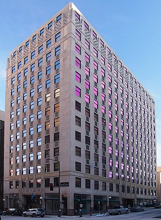
The Minnesota Building is a historic office building in Saint Paul, Minnesota, United States. The structure was placed on the National Register of Historic Places (NRHP) on June 10, 2009. The building was noted for its design, which was a harbinger for the transition from Classical architecture to the Art Deco/Moderne among commercial buildings in downtown Saint Paul; originally designed in a conservative style, the building became more Moderne as it was being built.
The Rondo neighborhood, or simply Rondo, is located within the officially designated Summit-University district in Saint Paul, Minnesota. The boundaries of the historically black neighborhood are sometimes referred to as Old Rondo. For much of the 20th century, Rondo was an important cultural and residential center of the black community in the Minneapolis–Saint Paul metropolitan region. The core of Old Rondo was demolished between 1956 and 1968, to make way for the construction of the Interstate 94 freeway. At least 650 families were displaced from the neighborhood, as well as many businesses and community locations. The neighborhood, although scarred by highway construction, remained a notable area in Saint Paul with a strong sense of cultural identity. Popular media and historians have the explored the impacts of highway construction and gentrification on Rondo residents past and present. In the 2000s, residents and public officials have discussed ways to reconnect the former community.
Charles Alfred Hausler was an American architect. Over his long career he had a major impact on the built environment of Saint Paul, Minnesota. As the first person to hold the office of city architect, he designed many public buildings, including Saint Paul's three Carnegie libraries. He also designed churches, commercial buildings, and homes in a variety of styles, including Neoclassical, Prairie School, and Art Deco.
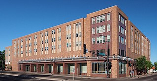
The East Side Freedom Library is an independent, non-profit library in the East Side neighborhood of Saint Paul, Minnesota, United States. Founded in 2013 by Beth Cleary and Peter Rachleff, it has occupied the Arlington Hills Carnegie library building since leasing it from the city of Saint Paul in 2014. The library's collections and programming focus on the labor history and diverse immigrant communities of the neighborhood.
This page is based on this Wikipedia article Text is available under the CC BY-SA 4.0 license; additional terms may apply. Images, videos and audio are available under their respective licenses.