St. Leo, Kansas | |
|---|---|
 | |
 St. Leo  St. Leo | |
| Coordinates: 37°31′45″N98°24′37″W / 37.52917°N 98.41028°W [1] | |
| Country | United States |
| State | Kansas |
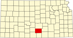
| County | Kingman |
| Elevation | 1,759 ft (536 m) |
| Time zone | UTC-6 (CST) |
| • Summer (DST) | UTC-5 (CDT) |
| ZIP Code | 67112 |
| Area code | 620 |
| FIPS code | 20-62350 [1] |
| GNIS ID | 474281 [1] |
St. Leo is a rural unincorporated community in southwestern Kingman County, Kansas, United States. [1] It is located eight miles south of Cunningham (and U.S. Route 54) at the intersection of SW 160 Ave and SW 80 St; also it is located six miles north of Nashville.