Willowdale, Kansas | |
|---|---|
 | |
 Willowdale  Willowdale | |
| Coordinates: 37°30′55″N98°18′6″W / 37.51528°N 98.30167°W [1] | |
| Country | United States |
| State | Kansas |
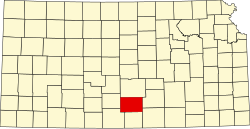
| County | Kingman |
| Elevation | 1,670 ft (510 m) |
| Time zone | UTC-6 (CST) |
| • Summer (DST) | UTC-5 (CDT) |
| ZIP code | 67142 |
| Area code | 620 |
| FIPS code | 20-79475 |
| GNIS ID | 474283 [1] |
Willowdale is a rural unincorporated community in Kingman County, Kansas, United States. [1] It is located 5 miles north of Zenda at the intersection of SW 100 Ave and SW 90 St.