Queensland University of Technology (QUT) is a public research university located in the urban coastal city of Brisbane, Queensland, Australia. QUT is located on two campuses in the Brisbane area viz. Gardens Point and Kelvin Grove. The university in its current form was founded in 1989, when the Queensland Institute of Technology (QIT) was made a university through the Queensland University of Technology Act 1988, with the resulting Queensland University of Technology beginning its operations from January 1989. In 1990, the Brisbane College of Advanced Education merged with QUT.
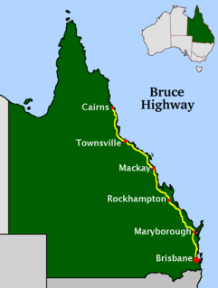
The Bruce Highway is a major highway in Queensland, Australia. Commencing in the state capital, Brisbane, it passes through areas close to the eastern coast on its way to Cairns in Far North Queensland. The route is part of the Australian National Highway and also part of Highway 1, the longest highway route in Australia. Its length is approximately 1,679 kilometres (1,043 mi); it is entirely sealed with bitumen. The highway is named after a popular former Queensland and federal politician, Harry Bruce. Bruce was the state Minister for Works in the mid-1930s when the highway was named after him. The highway once passed through Brisbane, but was truncated at Bald Hills when the Gateway Motorway became National Highway 1 upon its opening in December 1986.

The Division of Longman is an Australian electoral division in Queensland.
Burpengary is a town and suburb in the Moreton Bay Region, Queensland, Australia. In the 2016 census, the suburb of Burpengary had a population of 14,022 people.

Warwick is a town and locality in southeast Queensland, Australia, lying 130 kilometres (81 mi) south-west of Brisbane. It is the administrative centre of the Southern Downs Region local government area. The surrounding Darling Downs have fostered a strong agricultural industry for which Warwick, together with the larger city of Toowoomba, serve as convenient service centres. The town had an urban population of 15,380 as at June 2018, having declined slightly at an average annual rate of -0.15% year-on-year over the preceding five years.

Caboolture is a town and suburb in Moreton Bay Region, Queensland, Australia. In the 2016 census, the suburb of Caboolture had a population of 26,433 people. It is located on the north side of the Caboolture River, which separates the town from Morayfield and Caboolture South.

Carindale is a suburb of the City of Brisbane, Queensland, Australia. It is located 13.1 kilometres (8.1 mi) by road south-east of the Brisbane GPO, and borders Belmont, Carina, Carina Heights, Mackenzie, Mansfield, Mount Gravatt East, and Tingalpa. In the 2016 census, Carindale recorded a population of 15,740 people.

Strathpine is a suburb in the Moreton Bay Region, Queensland, Australia. In the 2016 census, Strathpine had a population of 9,503 people. It is home to the Pine Rivers District offices of the Moreton Bay Region, as well as many businesses. The area is home to Strathpine Centre, a medium-sized urban shopping centre.

Deception Bay is a coastal suburb in the Moreton Bay Region, Queensland, Australia. In the 2016 census, Deception Bay had a population of 19,850 people.

Morayfield is a town and suburb in the Moreton Bay Region, Queensland, Australia. In the 2016 census, the suburb of Morayfield had a population of 21,394 people.

Denver Edward Beanland is a former politician in Queensland, Australia. He was a Member of the Queensland Legislative Assembly and leader of the Queensland Liberal Party.
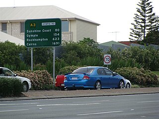
Gympie Road is a major road in the northern suburbs of Brisbane, Queensland, Australia. The road forms part of the main road route from the Brisbane Central Business District (CBD) to the northern suburbs, Sunshine Coast and east coast of Queensland.

The Moreton Bay Region is a local government area in the north of the Brisbane metropolitan city in South East Queensland, Australia. Established in 2008, it replaced three established local government areas, the City of Redcliffe and the Shires of Pine Rivers and Caboolture.

The Sunshine Coast Region is a local government area located in the Sunshine Coast district of South East Queensland, Australia.

Narangba is a town and suburb of the Moreton Bay Region, Queensland, Australia. It is located 34 km north of Brisbane CBD. This suburb has rural origins, but is being redeveloped as a residential suburb on the outskirts of the greater Brisbane metropolitan area. In the 2016 census, Narangba had a population of 18,573 people.

Redbank Plains is a suburb in the City of Ipswich, Queensland, Australia. In the 2016 census, Redbank Plains had a population of 19,299 people.

The Caboolture River is a small river in South East Queensland, Australia.
Burpengary East is a coastal suburb of Burpengary in the Moreton Bay Region, Queensland, Australia. In the 2016 census, Burpengary East had a population of 6,433 people.
Queensland Police is responsible for providing policing services to Queensland, Australia and crime statistics for the state are provided on their website.

Caboolture Sports Football Club is a semi-professional football club based in Burpengary, Queensland, Australia. Caboolture Sports plays in the Football Queensland Premier League, the second flight of Queensland football, following promotion from the third flight after winning the 2021 premiership. The club has a senior men, senior women and a variety of academy teams competing in Queensland competitions.
