The Thames and Severn Canal is a canal in Gloucestershire in the south-west of England, which was completed in 1789. It was conceived as part of a cargo route from Bristol and the Midlands to London, linking England's two largest rivers for better trade. The route climbs the steep Cotswold escarpment through the Golden Valley, tunnels underneath the summit of the Cotswold Edge, and emerges near the source of the Thames.

The English River Thames is navigable from Cricklade or Lechlade to the sea, and this part of the river falls 71 meters (234 feet). There are 45 locks on the river, each with one or more adjacent weirs. These lock and weir combinations are used for controlling the flow of water down the river, most notably when there is a risk of flooding, and provide for navigation above the tideway.
Sonning Lock is a lock and associated weir situated on the River Thames at the village of Sonning near Reading, Berkshire, England. The first lock was built by the Thames Navigation Commission in 1773 and it has been rebuilt three times since then. There is a weir a little upstream at the top of the island where Sonning Backwater separates from the main course of the river.

Bray Lock is a lock and weir on the River Thames in England near Bray and Dorney Reach, and is just above the M4 Bridge across the Thames. The lock is on the Buckinghamshire side of the river on the opposite bank from Bray itself and Maidenhead which are in Berkshire. Here, the county line stands roughly halfway between the lock and the opposite bank, following the course of the Thames itself. The pound lock was built by the Thames Navigation Commission relatively late, in 1845. The lock keeper's cottage is on an island between the lock and the weir.
Mapledurham Lock is a lock and weir situated on the River Thames in England, about 4 miles upstream of Reading. The lock was first built in 1777 by the Thames Navigation Commissioners and the present lock dates from 1908.

Shiplake Lock is a lock and weir situated on the River Thames in England between the villages of Shiplake and Lower Shiplake, Oxfordshire. It is just above the points where the River Loddon joins the Thames and Shiplake Railway Bridge crosses the river. The first pound lock was built by the Thames Navigation Commission in 1773.

The Thames Path is a National Trail following the River Thames from one of its sources near Kemble in Gloucestershire to the Woolwich foot tunnel, south east London. It is about 185 miles (298 km) long. A path was first proposed in 1948 but it only opened in 1996.

Hambleden Lock is a lock with a long weir situated on the River Thames in England, about 2 miles downstream of Henley Bridge. The lock is on the Berkshire bank between Aston and Remenham. Built by the Thames Navigation Commission in 1773, the lock is named after the village of Hambleden, a mile (1.5 km) to the north.

Iffley Lock is a lock on the River Thames in England near the village of Iffley, Oxfordshire. It is on the southern outskirts of Oxford. The original lock was built by the Oxford-Burcot Commission in 1631 and the Thames Navigation Commission replaced this in 1793. The lock has a set of rollers to allow punts and rowing boats to be moved between the water levels.

The River Wey Navigation and Godalming Navigation together provide a 20-mile (32 km) continuous navigable route from the River Thames near Weybridge via Guildford to Godalming. Both waterways are in Surrey and are owned by the National Trust. The River Wey Navigation connects to the Basingstoke Canal at West Byfleet, and the Godalming Navigation to the Wey and Arun Canal near Shalford. The Navigations consist of both man-made canal cuts and adapted parts of the River Wey.

Old Windsor Lock is a lock on the River Thames in England on the right bank beside Old Windsor, Berkshire. The lock marks the downstream end of the New Cut, a meander cutoff built in 1822 by the Thames Navigation Commissioners which created Ham Island. The lock and a wider footbridge give access to the island. Two weirs are associated; the smaller adjoins and the larger is upstream. The lock is the ninth lowest of the forty-five on the river.

Culham Lock is a lock on the River Thames in England close to Culham, Oxfordshire. It is on a lock cut to the north of the main stream, which approaches the large village of Sutton Courtenay. The lock was built of stone by the Thames Navigation Commission in 1809.

Abingdon Lock is a lock on the River Thames in England, less than 1 mile east and upstream of Abingdon, Oxfordshire, on the opposite bank of the river. It was originally built in 1790 by the Thames Navigation Commission.

Osney Lock is a lock on the River Thames in Oxford, England, where the village or island of Osney is next to the river.

Godstow Lock is a lock on the River Thames in Oxfordshire, England. It is between the villages of Wolvercote and Wytham on the outskirts of Oxford. The first lock was built of stone by Daniel Harris for the Thames Navigation Commission in 1790. It is the lock furthest upstream on the river which has mechanical (electro-hydraulic) operation - every lock upstream of Godstow utilises manual beam operation instead.

Eynsham Lock is a lock on the River Thames in England. It is on the southern bank near Swinford Oxfordshire. The large village of Eynsham is a little distance away on the northern bank.

Shifford Lock is a lock on the River Thames in England. It is in the centre of a triangle formed by the small villages of Shifford, Duxford and Chimney in Oxfordshire. It is at the start of a navigation cut built with the lock by the Thames Conservancy in 1898. This was the only new lock built on the non-tidal Thames in the era of falling revenue after the Thames Conservancy took over responsibilities of the Thames Navigation Commission. It replaced a flash lock in a weir about 3⁄4 mile (1.2 km) downstream.
Rushey Lock is a lock on the River Thames in England. It is on the northern bank of the river in Oxfordshire, at a considerable distance from any village, the nearest being Buckland Marsh, a hamlet on the road to Buckland to the south of the river.

Buscot Lock is a lock on the River Thames in England, near the village of Buscot, Oxfordshire.

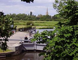
St John's Bridge is a two-section road bridge across the channel of the upper Thames near Lechlade, England, then across the lock cut to the south, the highest lock on the Thames. It is a Grade II listed building.