Guernsey is an island in the English Channel off the coast of Normandy, and is one of the British Channel Islands. It lies roughly north of Saint-Malo and to the west of Jersey and the Cotentin Peninsula. With several smaller nearby islands, it forms a jurisdiction within the Bailiwick of Guernsey - a British Crown dependency. The jurisdiction is made up of ten parishes on the island of Guernsey, three other inhabited islands, and many small islets and rocks.

Alderney is the northernmost of the inhabited Channel Islands. It is part of the Bailiwick of Guernsey, a British Crown dependency. It is 3 miles (5 km) long and 1 1⁄2 miles (2.4 km) wide. The area is 3 square miles (8 km2), making it the third-largest island of the Channel Islands, and the second largest in the Bailiwick. It is around 10 miles (15 km) from the west of La Hague on the Cotentin Peninsula, Normandy, in France, 20 miles (30 km) from the north-east of Guernsey and 60 miles (100 km) from the south coast of Great Britain. It is the closest of the Channel Islands to France and to the United Kingdom. It is separated from Cap de la Hague by the dangerous Alderney Race.

A war memorial is a building, monument, statue or other edifice to celebrate a war or victory, or to commemorate those who died or were injured in a war.

Fort Grey, colloquially known as the "cup and saucer", is a Martello tower located on a tidal rock in Rocquaine Bay in Saint Peter, Guernsey on the west coast of the island.

Saint Peter Port Harbour is located in Saint Peter Port, Guernsey. It was a natural anchorage used by the Romans which has been changed into an artificial harbour that is now the island's main port for passengers. Loose cargo, liquids and gas are shipped to and from St Sampson's harbour.
Braye Harbour is the main harbour on the north side of the Island of Alderney, in the Channel Islands, a dependency of the British Crown. A 3,000 feet (910 m) break-water was built by the Admiralty to protect the Navy in the 19th century shelters Braye Harbour. It is an artificial harbour created by building a pier or jetty. The harbour faces out onto the Swinge, which is part of the English Channel. It is here that most of the island's freight comes in. It is more or less a suburb of St Anne, which is a large settlement in Alderney that juts out on a rocky promontory on the west side, approximately 1 mile from the harbour.

Saint Sampson, is one of the parishes of Guernsey, Channel Islands. The parish is divided into two non-contiguous sections, the bulk of the parish lying on the east coast, with a smaller section lying on the west coast. The parish of Vale borders the parish to the north and also extends between the two parts of St. Sampson. What is currently the northern boundary of the parish originally ran along the south coast of Le Braye du Valle, a tidal channel that made the northern extremity of Guernsey, Le Clos du Valle, a tidal island. La Braye du Valle was drained and reclaimed in 1806 by the British Government as a defence measure. The eastern end of the former channel became the town and harbour of St. Sampson's, now the second biggest port in Guernsey. The western end of La Braye is now Le Grand Havre. The roadway called The Bridge across the end of the harbour at St. Sampson's recalls the bridge that formerly linked the two parts of Guernsey at high tide.

Castle Cornet is a large island castle in Guernsey, and former tidal island, also known as Cornet Rock or Castle Rock. Its importance was as a defence not only of the island, but of the roadstead. In 1859 it became part of one of the breakwaters of the Guernsey's main harbour, St Peter Port's harbour.
La Corbière is the extreme south-western point of Jersey in St. Brélade. The name means "a place where crows gather", deriving from the word corbîn meaning crow. However, seagulls have long since displaced the crows from their coastal nesting sites.

The German occupation of the Channel Islands lasted for most of the Second World War, from 30 June 1940 until their liberation on 9 May 1945. The Bailiwick of Jersey and Bailiwick of Guernsey are two British Crown dependencies in the English Channel, near the coast of Normandy. The Channel Islands were the only de jure part of the British Empire to be occupied by the Wehrmacht during the war.

Vassieux-en-Vercors is a commune in the department of Drôme in southeastern France.

Victoria Tower is a monument in Saint Peter Port, Guernsey, erected in honor of a visit by Queen Victoria and Prince Albert to the island in 1846.
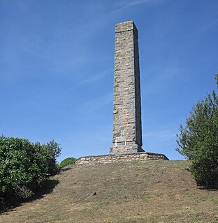
The Doyle Monument is located in Jerbourg Point in the southeastern point of the Bailiwick of Guernsey within St Martin Parish. It was built to honor Sir John Doyle (1756-1834), Lieutenant Governor of Guernsey 1803-1816, by the people of the island.

In Jersey and Guernsey, Liberation Day is celebrated each year on 9 May, to mark the end of the occupation by Nazi Germany during World War II. It is celebrated as Guernsey and Jersey's national day.

The Royallieu-Compiègne was an internment and deportation camp located in the north of France in the city of Compiègne, open from June 1941 to August 1944. French resistance fighters and Jews were among some of the prisoners held in this camp. It is estimated that around 40,000 people were deported from the Royallieu-Compiègne camp to other camps in the German territory of the time.

The Mémorial de la France combattante is the most important memorial to French fighters of World War II (1939–1945). It is situated below Fort Mont-Valérien in Suresnes, in the western suburbs of Paris. It commemorates members of the armed forces from France and the colonies, and members of the French Resistance. Fifteen representative French fighters were buried here in an elaborate ceremony on 11 November 1945. The present memorial was opened on 18 June 1960. It has a wall in which are set sixteen bronze reliefs that represent in allegorical terms the different phases, places and participants in the struggle.

SS Vega was owned by Stockholms Rederiaktieb Svea of Stockholm, a company that had owned steamships since 1886.

Liberation Route Europe is an international remembrance trail that connects the main regions along the advance of the Western Allied Forces toward the liberation of Europe and final stage of the Second World War. The route started in 2008 as a Dutch regional initiative in the Arnhem-Nijmegen area and then developed into a transnational route that was officially inaugurated in Arromanches on June 6, 2014, during the Normandy D-day commemorations. The route goes from Southern England,, through France, Belgium, Luxembourg, the Netherlands to Berlin, in Germany and then extends to the Czech Republic and Poland. The southern route starts in Italy. As a form of remembrance tourism LRE aims to unfold these Allied offensives of 1944 and 1945 in one narrative combining the different perspectives and points of view. By combining locations with personal stories of people who fought and suffered there, it gives visitors the opportunity to follow the Allied march and visit significant sites from war cemeteries to museums and monuments but also events and commemorations. In April 2019, Liberation Route Europe became a certified Cultural Route of the Council of Europe.

The Town Church is also known as the "Parish Church of St Peter Port", "Sancti Petri du Portu" and "Town Church of St Peter, Apostle & Martyr".

Lincoln's Inn War Memorial is a war memorial in Lincoln's Inn, London. It was erected in 1921 as a memorial to members of the Inn of Court who died on active service during the First World War. It became a Grade II listed building in 1999.
