Wensleydale is a valley in North Yorkshire, England. It is one of the Yorkshire Dales, which are part of the Pennines. The dale is named after the village of Wensley, formerly the valley's market town. The principal river of the valley is the Ure, which is the source of the alternative name Yoredale. The majority of the dale is within the Yorkshire Dales National Park; the part below East Witton is within the national landscape of Nidderdale.

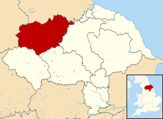
Richmondshire was a local government district of North Yorkshire, England, from 1974 to 2023. It covered a large northern area of the Yorkshire Dales including Swaledale and Arkengarthdale, Wensleydale and Coverdale, with the prominent Scot's Dyke and Scotch Corner along the centre. Teesdale lay to the north. With a total area of 1,319 km2, it was larger than seven of the English ceremonial counties.

Bedale, is a market town and civil parish in North Yorkshire, England. Bedale Beck is a River Swale tributary, the beck forms one of the Yorkshire Dales. The dale has a predominant agriculture sector and its related small traditional trades, although tourism is increasingly important. Northallerton is 7 miles (11 km) north-west, Middlesbrough 26 miles (42 km) north-west and York is 31 miles (50 km) south-west.

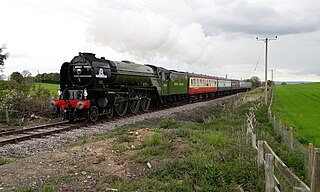
The Wensleydale Railway is a heritage railway in Wensleydale and Lower Swaledale in North Yorkshire, England. It was built in stages by different railway companies and originally extended to Garsdale railway station on the Settle-Carlisle line. Since 2003, the remaining line has been run as a heritage railway. The line runs 22 miles (35 km) between Northallerton West station, about a fifteen-minute walk from Northallerton station on the East Coast Main Line, and Redmire.

Hawes is a market town and civil parish in North Yorkshire, England, at the head of Wensleydale in the Yorkshire Dales, and historically in the North Riding of Yorkshire. The River Ure north of the town is a tourist attraction in the Yorkshire Dales National Park.

Leyburn is a market town and civil parish in North Yorkshire, England, sitting above the northern bank of the River Ure in Wensleydale. Historically in the North Riding of Yorkshire, the name was derived from 'Ley' or 'Le' (clearing), and 'burn' (stream), meaning clearing by the stream. Leyburn had a population of 1,844 at the 2001 census increasing to 2,183 at the 2011 Census. The estimated population in 2015 was 2,190.

Aysgarth is a village and civil parish in Wensleydale, in North Yorkshire, England. The village is in the Yorkshire Dales National Park, about 16 miles (26 km) south-west of Richmond and 22.6 miles (36.4 km) west of the county town of Northallerton.

Leyburn railway station is on the Wensleydale Railway, a seasonal, heritage service and serves the town of Leyburn in North Yorkshire, England. During the summer months it is served by at least three trains per day; at other times of the year the service is mainly at weekends and public holidays.

Finghall, historically spelt Fingall, is a village and civil parish in North Yorkshire, England. It is in lower Wensleydale south of the A684 road, about 6.2 miles (10 km) west of Bedale and about 5 miles (8 km) east of Leyburn.

Harmby is a village and civil parish in Lower Wensleydale, one mile south-east of Leyburn, in North Yorkshire, England. It is located roughly three miles east of the Yorkshire Dales National Park. Harmby has close links with Spennithorne, a village half a mile to the south-east. The two villages have a joint sports association.

West Witton is a village and civil parish in the Richmondshire district of North Yorkshire, England. Located in Wensleydale in the Yorkshire Dales it lies on the A684.

Wensley is a small village and civil parish in North Yorkshire, England. It consists of a few homes and holiday cottage, an inn, a pub and a historic church. It is on the A684 road 1 mile (1.6 km) south-west of the market town of Leyburn. The River Ure passes through the village.

Appersett is a hamlet in the Yorkshire Dales in the Richmondshire district of North Yorkshire, England one mile (1.6 km) west of Hawes. It lies on the A684 road and an unclassified road runs alongside Widdale Beck to connect with the B6255 road between Hawes and Ingleton.

Thornton Rust is a village and civil parish in North Yorkshire, England. It lies in the Yorkshire Dales about 2 miles (3.2 km) west of Aysgarth, high on the south bank of the River Ure in Wensleydale.

Preston-under-Scar is a village and civil parish in North Yorkshire, England. It is situated approximately 2 miles (4 km) west of Leyburn. The village population was 120 at the 2001 census, increasing to 170 by the 2011 census. The village is mentioned in the Domesday Book as belonging to Thorfin of Ravensworth, but the tenant-in-chief being Count Alan of Bedale. The name of the village derives form a mixture of Old English and Old Norse and was originally prēost tūn sker, which translates as Priests farm under rock.

The A684 is an A road that runs through Cumbria and North Yorkshire, starting at Kendal, Cumbria and ending at Ellerbeck and the A19 road in North Yorkshire. It crosses the full width of the Yorkshire Dales, passing through Garsdale and the full length of Wensleydale.

Constable Burton railway station is a disused railway station on the Wensleydale Railway, in North Yorkshire, England. It was built to serve Constable Burton Hall, the village and the farms in this rural area.

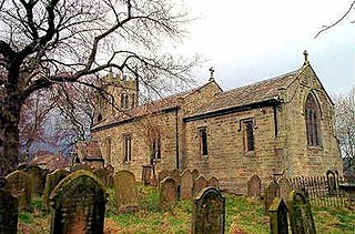
St Andrew's Church, Aysgarth, is a Grade II* listed parish church in the Church of England in Aysgarth, North Yorkshire. It is located on the south side of the River Ure.

In July 2019, parts of the Yorkshire Dales, in North Yorkshire, England, were subjected to above average rainfall for the time of year. The flash-flooding that followed affected many communities destroying bridges, sweeping roads away, causing landslips on railway lines and resulting in at least one public event being cancelled. The flooding even inundated the fire station in the town of Leyburn, in Wensleydale, whilst the crew were out helping those in need. The recovery took many weeks and months, with immediate help by the rescue services being bolstered by British Army personnel who assisted with the clean up.

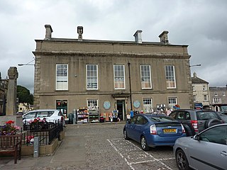
Leyburn Town Hall is a municipal building in the Market Place, Leyburn, North Yorkshire, England. The structure, which is used for retail purposes and as an events venue, is a grade II listed building.


