
Arrathorne is a hamlet and civil parish in the Richmondshire district of North Yorkshire, England. The settlement is 6 miles (9 km) south of Richmond, 6 miles (9 km) north-west of Bedale and 6 miles (9 km) east of Leyburn. The name has been recorded variously as Ergthorn, Erchethorn, Erghethorn, Erethorn and Arrowthorne. It means The Thornbush by the Shieling. Historically, the hamlet was in the Parish of Patrick Brompton in the Wapentake of Hang East.
Carlton Highdale is a civil parish in Coverdale, in the Richmondshire district of North Yorkshire, England. According to the 2001 census it had a population of 95.

Brough with St Giles is a village and a civil parish in the Richmondshire district of North Yorkshire, England. The civil parish also includes the settlements of Catterick Bridge and Walkerville, and Catterick Racecourse and the site of the Roman town of Cataractonium. According to the 2001 Census the parish had a population of 338, increasing to 801 at the 2011 census.

West Layton is a village and civil parish in the Richmondshire district of North Yorkshire, England, close to the border with County Durham and a few miles west of Darlington.
Kirby Hill, historically also known as Kirby-on-the-Hill, is a village and civil parish in the Richmondshire district of North Yorkshire, England. The village is about 1 mile (1.6 km) south of Ravensworth and about 4 miles (6 km) north-west of the town of Richmond.

Marske is a village and civil parish in the Richmondshire district of North Yorkshire, England, situated in lower Swaledale on the boundary of the Yorkshire Dales National Park, the village is approximately 5 miles west of Richmond. According to the UK 2011 Census, the population of the parish of Marske, including New Forest was 127. The parish includes the hamlets of Applegarth, Clints, Feldom and Skelton.
Downholme is a village and civil parish in the Richmondshire district of North Yorkshire, England. It is situated approximately 4 miles (6 km) west from the market town of Richmond and 16 miles (26 km) west from the county town of Northallerton. The village lies close to the edge of the Yorkshire Dales. The population as taken in the ONS Census of 2011 was less than 100, so details are included in the parish of Hudswell. In 2015, North Yorkshire County Council estimated the population of the village to be 50.
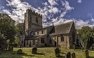
East Witton is a village and civil parish in Wensleydale in North Yorkshire, England. It lies south of Leyburn, in the Richmondshire district. Richard Whiteley is buried there; he and his partner, Kathryn Apanowicz, lived in the village.
Ellerton-on-Swale or Ellerton is a small village and civil parish about a mile east of Catterick in the Richmondshire district of North Yorkshire, England. In 2015, North Yorkshire County Council estimated the population of the parish at 110.

Hipswell is a village and civil parish in the Richmondshire district of North Yorkshire, England. The civil parish mainly comprises the northern part of Catterick Garrison. The village of Hipswell is at the eastern end of the civil parish, and effectively forms a suburb of Catterick Garrison.

Melmerby is a village and civil parish in the Richmondshire district of North Yorkshire, England. It lies in Coverdale in the Yorkshire Dales about 3 miles (4.8 km) south-west of Leyburn. Its neighbours are the villages of Carlton and Agglethorpe. The population of the civil parish was estimated at 40 in 2015.

West Scrafton is a village and civil parish in Coverdale in the Yorkshire Dales, England. It is located 4 miles (6.4 km) south west of Leyburn. It falls within the Richmondshire district of North Yorkshire. The population was estimated at 70 in 2013.

High Ellington is a village in lower Wensleydale in North Yorkshire, England, about 2.5 miles north-west of Masham. The smaller village of Low Ellington is 0.6 miles to the east. High Ellington is in Harrogate district, and is the largest settlement in the civil parish of Ellington High and Low, which also includes Low Ellington and the scattered settlement of Sutton. The population of the parish was estimated at 60 in 2013.

Healey is a small village and civil parish in the Harrogate district of North Yorkshire, England. It is situated in the valley of the River Burn, to the immediate west of Fearby. It is about three miles west of Masham in the Nidderdale Area of Outstanding Natural Beauty. There are several holiday cottages and four Grade II Listed buildings, one of which is Healey Mill, a former corn mill.

Castle Bolton is a village near Bolton Castle in Wensleydale, North Yorkshire, England. It gets its name from the castle which looks over the village green. The population of the civil parish was less than 100 at the 2011 census, so details are maintained in the parish of Redmire. In 2015, North Yorkshire County Council estimated the population to be 60.

Staintondale is a small village and civil parish in the Scarborough district of North Yorkshire, England. The village is situated 7 miles (11 km) north west of Scarborough town centre. The parish also includes the village of Ravenscar, 2 miles (3 km) north of the village of Staintondale, and the whole parish lies within the North York Moors National Park.

New Forest is a civil parish in the Richmondshire district of North Yorkshire, England. It lies 6 miles (10 km) west of Richmond.
Low Abbotside is a civil parish in the Richmondshire district of North Yorkshire, England. It is a rural parish on the north side of Wensleydale. There is no village in the parish. The population was estimated at 110 in 2012.
Ellerton Abbey is a civil parish in the Richmondshire district of North Yorkshire, England. It is located on the River Swale in lower Swaledale, 6 miles (10 km) south-west of Richmond. The population of the parish was estimated at 20 in 2016. The parish consists of farmland, a few scattered houses and an area of moorland which is part of the army training area associated with Wathgill Camp. The parish includes the site of the deserted medieval village of Ellerton, not to be confused with the modern village of Ellerton-on-Swale 11 miles to the east, but there is no modern village in the civil parish.

Walburn is a hamlet and civil parish in the Richmondshire district of North Yorkshire, England. It is located in lower Swaledale, 5 miles (8 km) south-west of Richmond. The population of the parish was estimated at 10 in 2016.

