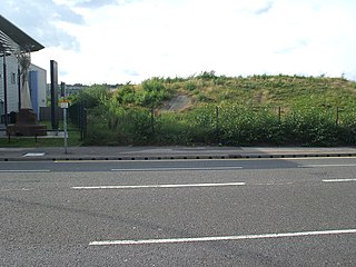
Attercliffe is an industrial suburb of northeast Sheffield, England on the south bank of the River Don. The suburb falls in the Darnall ward of Sheffield City Council.

The South Yorkshire Supertram, sometimes referred to as the Sheffield Supertram, is a tram and tram-train network covering Sheffield and Rotherham in South Yorkshire, England. The network is owned and operated by the South Yorkshire Mayoral Combined Authority (SYMCA).

Darnall ward—which includes the districts of Attercliffe, Carbrook, Darnall, Tinsley, and parts of Handsworth—is one of the 28 electoral wards in City of Sheffield, South Yorkshire, England. It is located in the eastern part of the city and covers an area of 17.4 km2. The population of this ward in 2011 was 23,489 people in 8,809 households. It is one of the wards that made up the Sheffield Attercliffe constituency, now the Sheffield South East constituency.

Attercliffe Chapel, also known as the Hill Top Chapel, is a Gothic chapel in Attercliffe, now a suburb of Sheffield, South Yorkshire, England. The chapel was constructed in 1629, when Attercliffe was a township separate from Sheffield, although in the same parish. Consecration took place on St. Matthias' day, 24 February 1630.

Sheffield Attercliffe was a parliamentary constituency in the City of Sheffield. It was created at the 1885 general election and abolished at the 2010 general election, when it was replaced by a new Sheffield South East constituency.

Parkgate is a suburb of Rotherham, South Yorkshire, England. It has since been consumed by its neighbour, Rawmarsh and is in the ward of Rawmarsh from which it has been indistinguishable since the early 20th century.

Darnall railway station is on the Sheffield to Lincoln Line and was built in 1849 to serve Darnall, a community about 3 miles (5 km) from the centre of Sheffield, South Yorkshire, England, and which later became a suburb of the city.

Broughton Lane railway station was a railway station in Sheffield, South Yorkshire, England. The station served the communities of Darnall, Attercliffe and Carbrook and was one of those opened on 1 August 1864 with the South Yorkshire Railway's extension south from Tinsley Junction to Woodburn Junction where it met the Manchester, Sheffield and Lincolnshire Railway (MS&LR). The day the line was opened the SYR became part of the MS&LR. This link allowed the MS&LR access to Barnsley and Rotherham from Sheffield Victoria.
Neepsend engine shed was an engine shed in Neepsend, Sheffield, South Yorkshire, England. It was built by the Sheffield, Ashton-under-Lyne and Manchester Railway to provide and service locomotives for passenger trains originating or changing at Sheffield Victoria and goods trains from various outlets within the area. The shed was built around 400 yards on the Sheffield side (southeast) of Neepsend railway station. The shed was situated on the north side of the line between Bardwell Road and Rutland Road. It began as a four road stone building with a double pitched slate roof.

Sheffield Tramway was an extensive tramway network serving the English city of Sheffield and its suburbs.

West Tinsley railway station is a former railway station in Sheffield, South Yorkshire, England.

Attercliffe railway station was built to serve the Parish of Attercliffe cum Darnall, then separated from but now part of the City of Sheffield, South Yorkshire, England.

The A6178 is a 4 digit A road in South Yorkshire, England. It begins in the Lower Don Valley area of Sheffield, at a junction with the A6109. The road heads northeast, crossing the River Don before passing through Attercliffe. The road passes a junction with Staniforth Road before passing the Don Valley Bowl, IceSheffield, the English Institute of Sport and the historic Hill Top Chapel. The road meets a junction with the A6102 at Carbrook, before continuing northeast as Attercliffe Common passing Valley Centertainment and the South Yorkshire Police headquarters. The road passes a number of car dealerships including Porsche and Mercedes before meeting the entrance to the Meadowhall Shopping Centre.

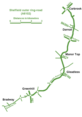
Sheffield Outer Ring Road is one of two main routes circumventing Sheffield, England, a partial ring around Sheffield City Centre and its suburbs.
Crookes is a suburb of the City of Sheffield, England, about 1.5 miles (2.4 km) west of the city centre. It borders Broomhill to the south, Walkley and Upperthorpe to the east and open countryside around the River Rivelin to the north. The population of the ward of the same name was 17,700 at the 2011 Census.
Eckington and Renishaw railway station is a former railway station between Eckington and Renishaw in Derbyshire, England.
Whittington railway station is a former railway station on the southern edge of New Whittington, Derbyshire, England.

The A6102 is a 4 digit A road in South Yorkshire, England.

Darnall is a suburb of eastern Sheffield, South Yorkshire, England. Darnall is approximately 3 miles (5 km) east-north-east of Sheffield city centre.

Sheffield South East is a constituency represented in the House of Commons of the UK Parliament since its 2010 creation by Clive Betts, a member of the Labour Party.


