The New Zealand state highway network is the major national highway network in New Zealand. Nearly 100 roads in the North and South Islands are state highways. All state highways are administered by the NZ Transport Agency.

U.S. Route 56 is an east–west United States highway that runs for approximately 640 miles (1,030 km) in the Midwestern United States. US 56's western terminus is at Interstate 25 Business, US 412 and New Mexico State Road 21 in Springer, New Mexico and the highway's eastern terminus is at US 71 in Kansas City, Missouri. Much of it follows the Santa Fe Trail.

U.S. Route 222 is a U.S. Highway that is a spur of US 22 in the states of Maryland and Pennsylvania. It runs for 95 miles (153 km) from US 1 in Conowingo, Maryland, north to the junction of Interstate 78 (I-78) and Pennsylvania Route 309 in Dorneyville, Pennsylvania. US 222 is almost entirely in Pennsylvania, and serves as the state's principal artery between the Lancaster and Reading areas in the west and the Lehigh Valley in the east.

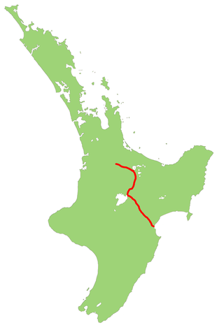
State Highway 1 is the longest and most significant road in the New Zealand road network, running the length of both main islands. It appears on road maps as SH 1 and on road signs as a white number 1 on a red shield, but it has the official designations SH 1N in the North Island, SH 1S in the South Island.

Pennsylvania Route 926 is a 26.2-mile-long (42.2 km) state route located west of Philadelphia in Chester County, Pennsylvania. The western terminus of the route is at PA 10 in Upper Oxford Township. The eastern terminus is at PA 3 in the Philadelphia suburb of Willistown Township. The route is known as Street Road for its entire length. For 0.9 miles (1.4 km), PA 926 runs along the county line between Delaware and Chester counties. The route passes through a mix of suburban and rural areas along its extent. PA 926 is two lanes and undivided its entire length.

State Highway 20 (SH 20), also known as the Southwestern Motorway, is a New Zealand state highway linking State Highway 1 at Manukau with State Highway 16 in Point Chevalier, via Māngere and Onehunga. Along with its spurs, State Highway 20A and 20B, the state highway serves Auckland Airport, the country's largest, therefore making SH 20 a key arterial route connecting the airport to the wider Auckland region and most of the upper North Island. The route also forms the southern part of the Western Ring Route, a 48 kilometres (30 mi) motorway route bypassing central Auckland.

State Highway 7 is a major New Zealand state highway. One of the eight national highways, it crosses the Southern Alps to link the West Coast Region with Canterbury and to form a link between the South Island's two longest highways, State Highway 1 and State Highway 6. Distances are measured from east to west with the major junction list going from east to west.

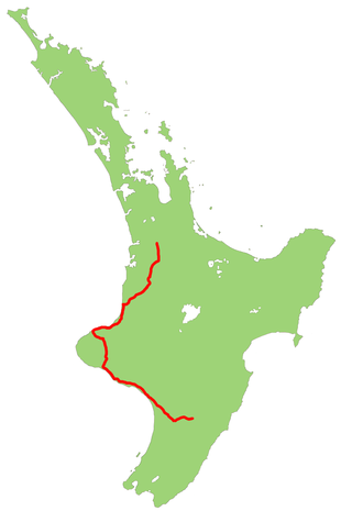
State Highway 6 is a major New Zealand state highway. It extends from the Marlborough region in the northeastern corner of the South Island across the top of the island, then down the length of the island, initially along the West Coast and then across the Southern Alps through inland Otago and finally across the Southland Plains to the island's south coast. Distances are measured from north to south.
State Highway 5, one of New Zealand's eight national highways, runs from State Highway 1 at Tīrau, in the south Waikato, to State Highway 2, close to the Hawkes Bay coast at Bay View, 10 km north of Napier. It is the second shortest of the national highways.
State Highway 3 (SH 3) is one of New Zealand's eight national state highways. It serves the west coast of the country's North Island and forms a link between State Highway 1 and State Highway 2. Distances are measured from north to south.

State Highway 30 (SH 30) is a New Zealand state highway, linking the Waikato and Bay of Plenty towns of Te Kūiti, Mangakino, Rotorua, and Whakatāne.
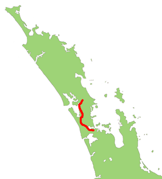
State Highway 16 is a New Zealand state highway linking central Auckland with Wellsford, via Auckland's Northwestern Motorway, Helensville and Kaukapakapa. It provides an alternative to SH 1 for traffic travelling between Auckland and parts of Northland from Wellsford northwards.

State Highway 119 is a 63.7-mile-long (102.5 km) state highway in north central Colorado. It extends in a southwest to northeast direction, from a junction with U.S. Route 6 in Clear Creek Canyon between Golden and Idaho Springs to a junction with Interstate 25 (I-25) east of Longmont. The southwest portion of the road is a scenic mountain drive providing dramatic vistas of the Front Range, while the northeast portion is a busy interurban thoroughfare. The city of Boulder separates these two vastly different sections of SH 119.

State Highway 29 (SH 29) is a New Zealand state highway that travels over the Kaimai Ranges linking the Bay of Plenty and Waikato regions. For most of its length, SH 29 is a two-lane single carriageway with occasional passing lanes and slow vehicle bays. 5 km of it near its eastern terminus is part of the Takitimu Drive Toll Road.
State Highway 50 (SH 50) is a New Zealand state highway that runs through the Hawke's Bay Region.
State Highway 25 is a New Zealand state highway that runs eastwards across the Hauraki Plains then northwards up the western side of Coromandel Peninsula and down the eastern side to Waihi. The route is very scenic and provides access to idyllic beach holiday locations. It is a major road for holidaymakers and tourists, with the summer period around Christmas and New Year's Eve a particularly busy time. It is single carriageway for the entire route. The road is windy in many parts and prone to accidents. It is New Zealand's third longest two-digit state highway, after SH 35 and SH 94. It is part of the Pacific Coast Highway. There is one spur road, SH 25A, which cuts across the peninsula west to east, almost intersecting SH 25 at both ends.
State Highway 39 (SH 39) is a New Zealand state highway that forms a western bypass of the city of Hamilton. Gazetted in 1999, it is a generally quicker route to get between Auckland and New Plymouth as well as connecting to the Waitomo Caves, just south of the SH 39 southern terminus. The southernmost 14 km section has a concurrency with SH 31, as this highway has existed for much longer.
State Highway 36 (SH 36) is a New Zealand state highway in the Bay of Plenty region in the North Island. It is one of two state highways that form a north–south connection between the cities of Tauranga and Rotorua, SH 36 being the most westerly of the two. It was identified as a quicker route to access the two cities and extensive work was done to upgrade the rural route to state highway quality.
State Highway 51 is a New Zealand state highway that runs between Napier and Hastings via Clive. Known locally as the Coastal Route, it was the main route between the two cities prior to the completion of the Hawke's Bay Expressway.

