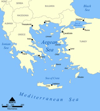
The Aegean Sea is an elongated embayment of the Mediterranean Sea between Europe and Asia. It is located between the Balkans and Anatolia, and covers an area of some 215,000 km2 (83,000 sq mi). In the north, the Aegean is connected to the Marmara Sea, which in turn connects to the Black Sea, by the straits of the Dardanelles and the Bosphorus, respectively. The Aegean Islands are located within the sea and some bound it on its southern periphery, including Crete and Rhodes. The sea reaches a maximum depth of 3,544 m (11,627 ft) to the east of Crete. The Thracian Sea and the Sea of Crete are main subdivisions of the Aegean Sea.

Via Maris is one modern name for an ancient trade route, dating from the early Bronze Age, linking Egypt with the northern empires of Syria, Anatolia and Mesopotamia — along the Mediterranean coast of modern-day Egypt, Israel, Turkey and Syria. In Latin, Via Maris means "way of the sea", a translation of the Greek ὁδὸν θαλάσσης found in Isaiah 9:1 of the Septuagint, itself a translation of the Hebrew דֶּ֤רֶךְ הַיָּם֙ . It is a historic road that runs in part along the Palestinian Mediterranean coast. It was the most important route from Egypt to Syria which followed the coastal plain before crossing over into the plain of Jezreel and the Jordan valley.

USS Forrest Royal (DD-872) was a United States Navy Gearing-class destroyer constructed following the end of World War II. The ship saw service in the Korean War and the Vietnam War before being sold to Turkey in 1971. The ship was renamed TCG Adatepe and remained in service until being scrapped in 1993.

Giresun Province is a province of Turkey on the Black Sea coast. Its adjacent provinces are Trabzon to the east, Gümüşhane to the southeast, Erzincan to the south, Sivas to the southwest, and Ordu to the west. Its area is 6,972 km2, and its population is 450,862 (2022). The provincial capital is Giresun. Its license-plate code is 28.

The Black Sea Region is a geographical region of Turkey. The largest city in the region is Samsun. Other big cities are Zonguldak, Trabzon, Ordu, Tokat, Giresun, Rize, Amasya and Sinop.

European route E 87 is part of the United Nations international E-road network. It is an important north–south road on the coast of Black Sea, running from Odesa (Ukraine), Tulcea (Romania), Constanţa (Romania), Varna (Bulgaria), Burgas (Bulgaria), Çanakkale (Turkey), İzmir (Turkey) to Antalya (Turkey).

European route E 97 is an A-class European Route in Ukraine, Russia, Georgia, and Turkey. The highway runs for 1,360 kilometres (850 mi) in total. It connects the North Black Sea region with the South Black Sea region along the eastern shores of the sea.
D.750 is a north to south state road in Turkey. It starts at Zonguldak at the Black Sea coast and ends at the junction of D.400 near Tarsus in the Mediterranean Region. It crosses many state roads.

D.850 is a north to south state road in Turkey. It starts at Ünye at Black Sea coast and ends at Öncüpınar, the Syrian border check point. Since it runs all the way from north to south it crosses the three main west to east highways namely D.100, D.300 and D.400.

D.550 is a north-to-south state road in Turkey. It runs mostly along the west coast of Turkey. It starts at Edirne and ends in Muğla. The first 226 kilometres (140 mi) of the road are in the European part of Turkey. Between Eceabat and Çanakkale, it passes over the Strait of Çanakkale by ferryboat. The rest of the road is in the Asiatic portion of Turkey. Being north to east road it crosses the major west to east roads in Turkey like D.200 in Çanakkale and D.400 in İzmir. It shares the same itinerary with D.100 between Edirne and Hafsa at the north and it shares the same itinerary with D.400 between Yatağan and Muğla at the south.

D.950 is a north-to-south state road in east Turkey. The 717 km road starts at Hopa at the Black Sea coast and ends at the Syrian border. It crosses many state roads, including the D.100, D.300 and D.400.
D.010, aka Black Sea Coastal Road, is a major west-east state road in northern Turkey that serves the Black Sea coast. The 1,427 km (887 mi) route starts in the west at the intersection D.014, 5 km (3.1 mi) southeast of Karasu, Sakarya Province, and terminates at the intersection D.060, 25 km (16 mi) northeast of Kars in eastern Anatolia. However, it is discontinued between Zonguldak and 10 km (6.2 mi) southwest of Çaycuma. The gap of 37 km (23 mi) distance is on the highway D.750.
İsmet İnönü Boulevard is a major avenue in Mersin, Turkey. It is named after İsmet İnönü (1884-1973), the second president of Turkish Republic between 1938 and 1950.

The Boğsak Tunnel is a road tunnel located in Silifke, Mersin Province in southern Turkey as part of the highway D.400.

Meydankale is the archaeological site of a ruined castle in Mersin Province, Turkey.
D.110 is a 172 km (107 mi) long east-west state road running from the border with Greece, near İpsala, to the junction with the D.100 in Kınalı. The road is the main route into Greece and one of only two roads that cross the Greek border from Turkey. The entire route is a four-lane highway, except for the two-lane bridge crossing the Maritsa river. The D.110 is a part of the E84 for its entire length and part of the E90 from the Greek border to Keşan.
D.915 is a north-to-south state road in northeastern Turkey. The 179 km-long (111 mi) road starts at Of, Trabzon on the coast of the Black Sea branching from D.010 and ends in Aşkale, Erzurum joining D.100 running in a high-elevation mountainous terrain. The route is composed of two parts crossed and overlapped by D.050 on a length of 13 km (8.1 mi) north of Bayburt. The northern part, between Of and Bayburt is 107 km (66 mi) long, and the southern part, between Bayburt and Aşkale is 72 km (45 mi). The northern section ,which is the Derebaşı curves, is considered one of the most dangerous routes in the world.

Babadıl Islands are two small Mediterranean islands in Turkey. They are named after the former name of the village Sipahili in the mainland facing the islands. According to the British captain Francis Beaufort who was tasked to map the Mediterranean coasts of Turkey in 1811–12, the names of the islands were Papadoulae, in the antiquity. Modern scholarship identifies the island group with Akonesiai, and the northern island with ancient Crambusa or Krambousa (Κράμβουσα).

Işıkkale is an ancient settlement in Turkey.
The 1944 Gulf of Edremit–Ayvacik earthquake occurred on October 6 at 05:34:48 local time in Balıkesir Province, Turkey. It measured 6.7 on the moment magnitude scale (Mw ) and occurred at a depth of 15 km (9 mi). The normal-faulting event had a maximum MSK-64 intensity of IX. A total of 73 people died and 275 others were injured.