Bilecik

Last updated • 3 min readFrom Wikipedia, The Free Encyclopedia
Bilecik
Seyh edebali turbesi.jpg
Bilecik, Kucukelmali tabiat parki goleti.jpg
Bilecik Tren Istasyonu.jpg
Ertugrul Gazi Turbesi.JPG
Dursun Fakih Turbesi.JPG
Bilecik Panaroma.jpg
Clockwise from top:Tomb of Sheikh Edebali, Küçükelmalı Natural Park, Bilecik railway station, Tomb of Ertuğrul, Tomb of Dursun Fakıh, Panorama of Bilecik
Bilecik City Logo.png
Turkey adm location map.svg
Red pog.svg
Bilecik
Location in Turkey
Marmara Region location map.svg
Red pog.svg
Bilecik
Bilecik (Marmara)
Coordinates: 40°08′35″N29°58′45″E / 40.14306°N 29.97917°E / 40.14306; 29.97917
Country Turkey
Province Bilecik
District Bilecik
Government
  MayorMelek Mızrak Subaşı (CHP)
Population
 (2021) [1]
74,457
Time zone UTC+3 (TRT)
Postal code
11000
Area code 0228
Website www.bilecik.bel.tr

Bilecik is a city in northwestern Anatolia, Turkey. It is the seat of Bilecik Province and Bilecik District. [2] Its population is 74,457 (2021). [1] The mayor is Melek Mızrak Subaşı (CHP).

Contents

The town is famous for its numerous restored Turkish houses. It is increasingly becoming more attractive to tourists. With its rich architectural heritage, Bilecik is a member of the European Association of Historic Towns and Regions. [3] 30 kilometres (19 miles) southeast from Bilecik is Söğüt, a small town, where the Ottoman Empire was founded in 1299.

History

Prehistory

Turan Efe et al. reported two prehistoric settlements in the immediate vicinity of modern Bilecik. The first is located in the Bahçelievler neighborhood, about 100 m off the main street heading north to Gülümbe. The site was discovered when the land across the street was being excavated for the construction of an apartment building. The Bahçelievler settlement appears to have consisted of a single stratum, corresponding to the Classic Fikirtepe phase of the Late Neolithic. The second site is a höyük (mound) located at a site called Çiftlik Alanı, just west of the modern town of Bilecik, on the road to Çakırpınar overlooking the Hamsu Dere stream. Associated materials were mainly dated to the Early Bronze Age III period, with a lesser amount of Early Bronze Age II material.İnegöl Gray Ware was especially predominant among these finds. [4]

Roman and Byzantine archaeology

An assemblage of Roman stones exists at Bilecik today, but these were originally gathered from other places, so they cannot be taken as evidence of a settlement here during the Roman or early Byzantine periods. However, there is clear archaeological evidence of a settlement at Bilecik by the 1200s and early 1300s, at the very end of Byzantine rule in the region. On a rocky peak near the modern town are the foundations of a Byzantine fortress. Within its enclosing walls, and especially at its "foot" by the lower town, a number of late Byzantine (i.e. 13th/early 14th centuries) and early Ottoman ceramics have been found among the stone blocks and glass fragments. [5] :461–2 Also, at the Çiftlik Alanı site west of Bilecik proper, Efe et al. reported the presence of unspecified Byzantine material. [4] :497

Recorded history

Bilecik's recorded history begins with the Ottoman conquest, at the turn of the 14th century. It is necessary to assume that Belokome was one of the Serbian or Bulgarian settlements settled in this region by Byzantine Empire in the late 12th century and that the name Belokome was pronounced in the Slavic language. (Instead of Bilecik, the Greek name of the region should have taken a form like *Vilegüme/Veligöme in Turkish.) [6] [7] According to Aşıkpaşazade's semi-legendary account, Osman I captured the fortress of Bilecik in 699 AH (1299-1300 CE), and the town thus became part of the nascent Ottoman Empire. Bilecik is sometimes identified, based on a vague phonetic resemblance, with the attested Byzantine village of Belokomis which is mentioned as being captured by "Atman" (Osman) in 1304, but Klaus Belke dismisses this as geographically impossible. [5] :461

From 1867 until 1922, Bilecik was part of Hüdavendigâr vilayet.

Culture

Bilecik has been nominated as the most irrelevant province in the popular Turkish internet dictionary Ekşi Sözlük. [8] This article sparked an online debate regarding the validity and reality of Bilecik as an actual province.

Geography

Bilecik is located in a mountainous area west of the Karasu, a left-hand tributary of the Sakarya River. [5] :461 It is located in the Southern Marmara section of the Marmara Region. It is one of the least populated provincial capitals in Turkey. Bilecik consists of the quarters Pelitözü, Aşağıköy, Osmangazi, Orhangazi, Cumhuriyet, Gazipaşa, Ismetpaşa, Istasyon, Istiklal, Beşiktaş, Hürriyet, Bahcelievler and Ertuğrulgazi. [8]

Landforms

Mountains cover 32% percent of the province.

Climate

Bilecik has a hot summer Mediterranean climate (Köppen climate classification: Csa), or a temperate oceanic climate (Trewartha climate classification: Do), with cool, wet and often snowy winters, and hot and dry summers. Summers are hot and dry with temperatures exceeding 28.0 °C (82.4 °F) during the peak of summer which are the driest months. Winters are cold and it frequently snows between the months of December and March.

Highest recorded temperature:41.0 °C (105.8 °F) on 13 July 2000
Lowest recorded temperature:−16.0 °C (3.2 °F) on 13 January 1950 [9]

Climate data for Bilecik (1991–2020, extremes 1939–2023)
MonthJanFebMarAprMayJunJulAugSepOctNovDecYear
Record high °C (°F)22.3
(72.1)
24.6
(76.3)
30.2
(86.4)
33.3
(91.9)
36.6
(97.9)
38.2
(100.8)
41.0
(105.8)
40.6
(105.1)
38.4
(101.1)
34.3
(93.7)
28.6
(83.5)
25.0
(77.0)
41.0
(105.8)
Mean daily maximum °C (°F)6.3
(43.3)
8.5
(47.3)
12.4
(54.3)
17.5
(63.5)
22.7
(72.9)
26.8
(80.2)
29.6
(85.3)
30.0
(86.0)
25.9
(78.6)
20.2
(68.4)
13.7
(56.7)
7.9
(46.2)
18.5
(65.3)
Daily mean °C (°F)2.7
(36.9)
4.1
(39.4)
7.2
(45.0)
11.6
(52.9)
16.5
(61.7)
20.4
(68.7)
22.9
(73.2)
23.0
(73.4)
19.1
(66.4)
14.4
(57.9)
8.9
(48.0)
4.5
(40.1)
12.9
(55.2)
Mean daily minimum °C (°F)0.0
(32.0)
0.8
(33.4)
3.2
(37.8)
6.9
(44.4)
11.3
(52.3)
14.8
(58.6)
17.0
(62.6)
17.4
(63.3)
13.9
(57.0)
10.2
(50.4)
5.5
(41.9)
1.9
(35.4)
8.6
(47.5)
Record low °C (°F)−16.0
(3.2)
−14.3
(6.3)
−11.6
(11.1)
−6.0
(21.2)
1.0
(33.8)
6.0
(42.8)
7.7
(45.9)
8.2
(46.8)
3.2
(37.8)
−0.8
(30.6)
−9.2
(15.4)
−14.5
(5.9)
−16.0
(3.2)
Average precipitation mm (inches)48.0
(1.89)
44.4
(1.75)
48.7
(1.92)
48.6
(1.91)
43.9
(1.73)
50.6
(1.99)
16.4
(0.65)
11.2
(0.44)
27.0
(1.06)
50.1
(1.97)
37.1
(1.46)
56.1
(2.21)
482.1
(18.98)
Average precipitation days13.6313.212.710.7710.278.673.773.775.68.679.5713.43114
Average snowy days84.72.90.60000000.7420.9
Average relative humidity (%)76.973.468.764.96563.96263.264.970.572.276.768.5
Mean monthly sunshine hours 96.1107.4148.8192.0248.0288.0328.6310.0243.0170.5126.086.82,345.2
Mean daily sunshine hours 3.13.84.86.48.09.610.610.08.15.54.22.86.4
Source 1: Turkish State Meteorological Service [9]
Source 2: NOAA NCEI(humidity), [10] Meteomanz(snow days 2013-2023) [11]

Related Research Articles

<span class="mw-page-title-main">Osman I</span> Founder of the Ottoman Empire (died 1323/4)

Osman I or Osman Ghazi was the founder of the Ottoman Empire. While initially a small Turkoman principality during Osman's lifetime, his beylik transformed into a vast empire in the centuries after his death. It existed until 1922 shortly after the end of World War I, when the sultanate was abolished.

<span class="mw-page-title-main">Orhan</span> 2nd Sultan of the Ottoman Empire from 1323/4 to 1362

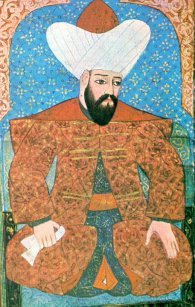
Orhan Ghazi was the second sultan of the Ottoman Empire from 1323/4 to 1362. He was born in Söğüt, as the son of Osman I.

<span class="mw-page-title-main">Söğüt</span> Town in Marmara, Turkey

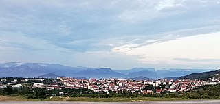
Söğüt is a town in Bilecik Province, Turkey. It is the seat of Söğüt District. Its population is 13,566 (2021). The mayor is İsmet Sever (MHP), elected in 2019.

<span class="mw-page-title-main">Edirne</span> City in Edirne, Turkey

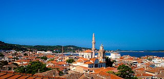
Edirne, historically known as Adrianople, is a city in Turkey, in the northwestern part of the province of Edirne in Eastern Thrace. Situated 7 km (4.3 mi) from the Greek and 20 km (12 mi) from the Bulgarian borders, Edirne was the second capital city of the Ottoman Empire from 1369 to 1453, before Constantinople became its capital.

<span class="mw-page-title-main">Çorum</span> Municipality in Turkey

Çorum is a northern Anatolian city in Turkey. Çorum is located inland in the central Black Sea Region of Turkey and is approximately 244 km (152 mi) from Ankara and 608 km (378 mi) from Istanbul. It is the seat of Çorum Province and of Çorum District. Its population is 269,595 (2022). The city has an elevation of 801 m (2,628 ft) above sea level.

<span class="mw-page-title-main">Bilecik Province</span> Province of Turkey

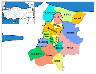
Bilecik Province is a province in midwest Turkey, neighboring Bursa to the west, Kocaeli and Sakarya to the north, Bolu to the east, Eskişehir to the southeast and Kütahya to the south. Its area is 4,179 km2, and its population is 228,673 (2022). Most of the province laid down in Marmara Region but eastern parts of Gölpazarı and Söğüt district and districts of İnhisar and Yenipazar remained in Black Sea Region, smaller southeastern parts of Bozüyük and Söğüt remained in Central Anatolia Region and smaller southwestern part of Bozüyük remained in Aegean Region.

<span class="mw-page-title-main">Adıyaman</span> Municipality in Turkey

Adıyaman is a city in southeastern Turkey. It is the administrative centre of Adıyaman Province and Adıyaman District. Its population is 267,131 (2021). The inhabitants of the city are mostly Kurdish.

<span class="mw-page-title-main">Geyve</span> District and municipality in Sakarya, Turkey

Geyve is a municipality and district of Sakarya Province, Turkey. Its area is 662 km2, and its population is 50,799 (2022). The closest international airport is Istanbul Sabiha Gökçen International Airport, 139 km (86 mi) from Geyve. It is the largest district of Sakarya Province in terms of area. Geyve is located at the foot of Geyve Gorge, which is set between two mountain ranges and lies along the Sakarya River. Geyve region has an impressive green landscape and productive nature. Geyve is relatively close to many important cities in Turkey; 179 km (111 mi) to Istanbul, 30 km to Adapazarı, 75 km (47 mi) to Izmit, 139 km to Bursa, 156 km (97 mi) to Eskişehir, 167 km (104 mi) to Bolu by road.

<span class="mw-page-title-main">Düzce</span> Municipality in Turkey

Düzce is a city in northwestern Turkey, the capital city of Düzce Province, the eighty-first province in the country. It is the seat of Düzce District. Its population is 194,097.

<span class="mw-page-title-main">Aydın</span> Metropolitan municipality in Turkey

Aydın is a city in and the seat of Aydın Province in Turkey's Aegean Region. The city is located at the heart of the lower valley of Büyük Menderes River at a commanding position for the region extending from the uplands of the valley down to the seacoast. The city forms the urban part of the Efeler district, with a population of 259,027 in 2022. Aydın city is located along a region which was famous for its fertility and productivity since ancient times. Figs remain the province's best-known crop, although other agricultural products are also grown intensively and the city has some light industry.

<span class="mw-page-title-main">Ayvalık</span> District and municipality in Balıkesir, Turkey

Ayvalık, formerly also known as Kydonies, is a municipality and district of Balıkesir Province, Turkey. Its area is 305 km2, and its population is 74,030 (2022). It is a seaside town on the northwestern Aegean coast of Turkey. The town centre is connected to Cunda Island by a causeway and is surrounded by the archipelago of Ayvalık Islands, which face the nearby Greek island of Lesbos.

<span class="mw-page-title-main">Yalova</span> Municipality in Turkey

Yalova is a market-gardening town located in northwestern Turkey on the eastern coast of the Sea of Marmara. It is the seat of Yalova Province and Yalova District. Its population is 133,109 (2022). A largely modern town, it is best known for the spa resort at nearby Termal, a popular summer retreat for residents of Istanbul.

<span class="mw-page-title-main">Beyşehir</span> District and municipality in Konya, Turkey

Beyşehir is a municipality and district of Konya Province, Turkey. Its area is 2,054 km2, and its population is 77,690 (2022). The town is located on the southeastern shore of Lake Beyşehir and is marked to the west and the southwest by the steep lines and forests of the Taurus Mountains, while a fertile plain, an extension of the lake area, extends in the southeastern direction.

Pazaryeri, is a town in Bilecik Province in the Marmara region of Turkey. It is the seat of Pazaryeri District. Its population is 6,243 (2021). The district has several small lakes, as well as a number of buildings in traditional Ottoman style. The mayor is Zekiye Tekin. Pazaryeri is one of the most important hop producers in Turkey. The town has famous local dishes like helva and boza.

<span class="mw-page-title-main">Sungurlu</span> District in Çorum, Turkey

Sungurlu is a town in Çorum Province in the Black Sea Region of Turkey, located 72 km south-west of the city of Çorum. It is the seat of Sungurlu District. Its population is 30,275 (2022). The mayor is Muhsin Dere (MHP).

<span class="mw-page-title-main">Marmara Region</span> Region in Turkey

The Marmara Region is a geographical region of Turkey.

Paşalimanı Island, formerly Halone, is an island in the southern Sea of Marmara in Turkey. The island is the fifth largest island of Turkey and administratively belongs to the Erdek town of Balikesir Province in northwestern Turkey. The island has five small villages and has 962 population in total. Paşalimanı Island is also part of the Marmara Archipelago along with three other islands Marmara, Avşa and Ekinlik.

<span class="mw-page-title-main">Yenişehir, Bursa</span> District and municipality in Bursa, Turkey

Yenişehir is a municipality and district of Bursa Province, Turkey. Its area is 720 km2, and its population is 54,844 (2022). It is 52 km far from the east of Bursa and Bursa city center. Bursa's international airport is within the borders of Yenişehir. For this reason, the airport is called 'Yenişehir Airport'.

<span class="mw-page-title-main">Osmangazi Tunnel</span>

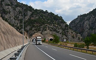
The Osmangazi Tunnel, formerly Kocatepe Tunnel, is a road tunnel constructed on the Adapazarı–Bilecik state highway D.650 in Bilecik Province, western Turkey.

<span class="mw-page-title-main">Qiniq (tribe)</span> Oghuz-Turkmen tribe

Qiniq also spelled Qïnïq, Qynyk or Qynyq, was an Oghuz Turkic tribe.

References

  1. 1 2 "Address-based population registration system (ADNKS) results dated 31 December 2021" (XLS) (in Turkish). TÜİK . Retrieved 30 January 2023.
  2. İl Belediyesi, Turkey Civil Administration Departments Inventory. Retrieved 30 January 2023.
  3. "HistoricTowns.org - Turkey". Archived from the original on 2008-09-10. Retrieved 2006-05-13.
  4. 1 2 Efe, Turan; Türkteki, Murat; Sarı, Deniz; Fidan, Erkan (2014). "Bilecik Ili 2013 Yılı Yüzey Araştırması" (PDF). Araştırma Sonuçları Toplantıları. 31: 495–504. Retrieved 20 June 2024.
  5. 1 2 3 Belke, Klaus (2008). Tabula Imperii Byzantini Bd. 13. Bythenien und Hellespont. Wien: Johannes Koder. ISBN   978-3-7001-8329-7 . Retrieved 19 June 2024.
  6. Georgios Paxymérês, Tarih [y. 1308]; ed. Bekker, Bonn 1835.
  7. "İndex Anatolicus: Türkiye Yer Adları Sözlüğü".
  8. 1 2 Mahalle, Turkey Civil Administration Departments Inventory. Retrieved 30 January 2023.
  9. 1 2 "Resmi İstatistikler: İllerimize Ait Mevism Normalleri (1991–2020)" (in Turkish). Turkish State Meteorological Service. Retrieved 27 June 2021.
  10. "World Meteorological Organization Climate Normals for 1991-2020: Bilecik" (CSV). ncei.noaa.gov. National Oceanic and Atmosoheric Administration . Retrieved 24 June 2024. WMO station number: 17120
  11. "Bilecik - Weather data by months". meteomanz. Retrieved 18 July 2024.