The Dwight D. Eisenhower National System of Interstate and Defense Highways, commonly known as the Interstate Highway System, or the Eisenhower Interstate System, is a network of controlled-access highways that forms part of the National Highway System in the United States. The system extends throughout the contiguous United States and has routes in Hawaii, Alaska, and Puerto Rico.

Ross Township is a township in Allegheny County, Pennsylvania, United States. It is adjacent to the northern border of Pittsburgh. The population of the township was 33,176 at the 2020 census. While most of the township is residential, a retail corridor is located along McKnight Road along with business districts on U.S. Route 19 and Babcock Boulevard.
A routenumber, designation or abbreviation is an identifying numeric designation assigned by a highway authority to a particular stretch of roadway to distinguish it from other routes and, in many cases, also to indicate its classification, general geographical location and/or orientation. The numbers chosen may be used solely for internal administrative purposes; however, in most cases they are also displayed on roadside signage and indicated on maps.
The Virginia Department of Transportation (VDOT) is the agency of the state government responsible for transportation in the state of Virginia in the United States. VDOT is headquartered at the Virginia Department of Highways Building in downtown Richmond. VDOT is responsible for building, maintaining, and operating the roads, bridges, and tunnels in the commonwealth. It is overseen by the Commonwealth Transportation Board, which has the power to fund airports, seaports, rail, and public transportation.

The Federal Highway Administration (FHWA) is a division of the United States Department of Transportation that specializes in highway transportation. The agency's major activities are grouped into two programs, the Federal-aid Highway Program and the Federal Lands Highway Program. Its role had previously been performed by the Office of Road Inquiry, Office of Public Roads and the Bureau of Public Roads.

All motorised vehicles plying on public roads in India are tagged with a registration or licence number. The vehicle registration plate is issued by a Regional Transport Office (RTO), the district-level authority on road matters in the respective state or Union Territory. The number plates are mandatory on both front and rear of the vehicle and are required to be in modern arabic numerals with latin letters. Complete specification of registration plates are specified under the HSRP: High Security Registration Plate rules.

The Cincinnati, Hamilton and Dayton Railway (CH&D) was a railroad based in the U.S. state of Ohio that existed between its incorporation on March 2, 1846, and its acquisition by the Baltimore and Ohio Railroad in December 1917. It was originally chartered to build from Cincinnati to Hamilton, Ohio, and then to Dayton, a distance of 59 mi (95 km); further construction and acquisition extended the railroad, and by 1902 it owned or controlled 640 mi (1,030 km) of railroad. Its stock and bond value plunged in late 1905 after "financial mismanagement of the properties" was revealed. The company was reorganized as the Toledo and Cincinnati Railroad in 1917.
The South Carolina State Highway System is the fourth largest state-maintained system of state highways in the country. It consists of Interstates, U.S. highways, state highways, and secondary roads, totaling approximately 41,500 miles (66,800 km).

Malaysian State Roads System are the secondary roads in Malaysia with a total length of 247,027.61 km. The construction and maintenance works of state roads in Malaysia is managed by Malaysian Public Works Department (JKR) of each state and funded by state governments. The standard of the state roads is similar with the federal roads except for the coding system, where the codes for state roads begin with state codes followed by route number, for example Johor State Route J32 is labeled as J32. If a state road crosses the state border, the state code will change, for example route B20 in Salak Tinggi, Selangor will change to N20 after crossing the border of Negeri Sembilan to Nilai.

Dr. Von D. Mizell-Eula Johnson State Park is a Florida State Park located in Dania Beach, Florida off Florida State Road A1A. The park is named for late civil rights activists Von Mizell and Eula Johnson, who first pressured Broward County to have at least one beach for African Americans, then led wade-ins in Ft. Lauderdale in 1961 that led to desegregation of the county's beaches the following year. The park's former namesake, John U. Lloyd, served as Broward County Attorney for over 30 years and was instrumental in obtaining the land for the park.

An unsigned highway is a highway that has been assigned a route number, but does not bear road markings that would conventionally be used to identify the route with that number. Highways are left unsigned for a variety of reasons, and examples are found throughout the world. Depending on the policy of the agency that maintains the highway, and the reason for not signing the route, the route may instead be signed a different designation from its actual number, with small inventory markers for internal use, or with nothing at all.
Greenways Road is a road and neighbourhood in Chennai, India. It is lined with the official residences of ministers of Tamil Nadu state government and judges of Chennai High Court. It also houses the Tahsildar district magistrate office of the Mylapore-Triplicane taluk. A park and memorial named after B. R. Ambedkar, the Tamil Nadu Dr. Ambedkar Law University, Tamil Nadu Judicial Academy, Jesus Calls Prayer Tower, Kutchipudi Art Academy, Tamil Nadu Government Music College, Tamil Nadu Human Rights Commission, Anna Institute of Management, Dr. MGR Janaki College of Arts and Science for Women are located on this road. Part of this road is now renamed after D. G. S. Dinakaran. After the Eliphanstone Bridge was built a new road connecting Adyar to Greenways Road named Adyar Bridge Road was formed. Meenakshi Cinetone, one of the oldest cinema studios in Chennai and Jupiter Studios was also located on this road.

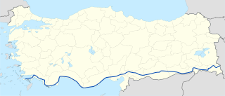
D.400 is an east–west state road in southern Turkey. The 2,057-kilometre (1,278 mi) road starts at Datça in the southwest corner of the Anatolian peninsula and ends at the Iranian border at Esendere.

D404 is a state road connecting A7 motorway Draga interchange to the eastern part of the city of Rijeka, and to the Port of Rijeka, Brajdica container cargo terminal. The road is 3.5 km (2.2 mi) long, and 60% of the route is carried by various structures, such as tunnels and viaducts. The road opening had a number of delays, even though associated construction works were virtually complete for a long time. In the meantime, the road was used as a parking space. Finally, on May 30, 2011, the D404 road was open to traffic considerably enhancing access to Brajdica and eastern parts of Rijeka. Approximately two thirds of the road are classified as an expressway with 3 lanes, although the section between Vežica and Draga interchanges has 4 lanes.

D403 is a state road connecting A7 motorway Škurinje interchange to the centre of the city of Rijeka, and to the Port of Rijeka West terminal. The road is 2.5 km (1.6 mi) long.

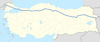
D.100 is a west to east state road in Turkey. It starts at Kapıkule, the Bulgarian border check point, and ends in Gürbulak, the Iranian border check point. Since it runs all the way from west to east it crosses most of the north to south state roads including D.650, D.750, D.850 and D.950.


