
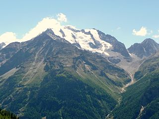
The Dom is a mountain of the Pennine Alps, located between Randa and Saas-Fee in the canton of Valais in Switzerland. With a height of 4,545 m (14,911 ft), it is the seventh highest summit in the Alps, overall. Based on prominence, it can be regarded as the third highest mountain in the Alps, and the second highest in Switzerland, after Monte Rosa. The Dom is the main summit of the Mischabel group, which is the highest massif lying entirely in Switzerland.

The Nadelhorn is a mountain in the Pennine Alps in Switzerland. It is the highest point on the Nadelgrat, a high-level ridge running roughly north–south above the resort of Saas-Fee to the east, and the Mattertal to the west. Its three ridges join to form a sharp-pointed summit, which looks like a needle when seen from the north. The other summits on the Nadelgrat are the Stecknadelhorn and Hohberghorn.

The Stecknadelhorn is a mountain in the Pennine Alps in Switzerland. It lies on the Nadelgrat, a high-level ridge running roughly north–south above the resort of Saas Fee to the east, and the Mattertal to the west.

The Hohberghorn is a mountain in the Pennine Alps in Switzerland. It lies towards the northern end of the Nadelgrat, a high-level ridge running roughly north–south, north of the Dom, above the resort of Saas-Fee to the east, and the Mattertal to the west.

The Strahlhorn is a mountain of the Swiss Pennine Alps, located south of Saas-Fee and east of Zermatt in the canton of Valais. It lies on the range that separates the Mattertal from the Saastal and is located approximately halfway between the Rimpfischhorn and the Schwarzberghorn.

The Dürrenhorn is a summit in the Pennine Alps in Switzerland. It lies towards the northern end of the Nadelgrat, a high-level ridge running roughly north–south above the resort of Saas-Fee to the east, and the Mattertal to the west. It is part of the Mischabel range, which culminates at the Dom.
The Balfrin is a mountain of the Swiss Pennine Alps, located north of the Dom in the canton of Valais. It belongs to the Mischabel massif, which lies between the Mattertal and the Saastal.

The Brunegghorn is a mountain of the Pennine Alps, overlooking the Mattertal in the canton of Valais. It is part of the Weisshorn group. On the west side of the mountain flows the Brunegg Glacier.
The Schwarzhorn is a mountain of the Swiss Pennine Alps, overlooking the Augstbord Pass in the canton of Valais. It lies on the range between the Turtmanntal and the Mattertal.
The Färichhorn is a mountain of the Pennine Alps, located between the Mattertal and the Saastal in the canton of Valais. It lies north of the Balfrin, at a height of 3,292 metres above sea level.

Tête Blanche is a mountain of the Pennine Alps on the Swiss-Italian border. Its summit is the tripoint between the valleys of Hérens, Mattertal and Valpelline, thus forming the linguistic tri-point between French, German, and Italian-speaking areas.

Tête de Valpelline is a mountain of the Pennine Alps, located on the Swiss-Italian border. It lies west of the Dent d'Hérens, between the valleys of Mattertal (Valais) and Valpelline.

The Schwarzberghorn is a mountain of the Pennine Alps, located on the border between Switzerland and Italy. Its summit is the tripoint between the valleys Mattertal, Saastal and Valle Anzasca and the southernmost point of the Mischabel-Strahlhorn chain, and northern end of the Weissgrat.
The Sparruhorn is a mountain of the Swiss Pennine Alps, overlooking St. Niklaus in the canton of Valais. It lies on the range between the Turtmanntal and the Mattertal, although it is located within the Mattertal and not on the watershed between the two valleys.

The Ulrichshorn is a mountain of the Swiss Pennine Alps, overlooking Saas-Fee in the canton of Valais. It is located north of the Nadelhorn, in the Mischabel range, which lies between the Mattertal and the Saastal.
Schwarzhorn may refer to mountains/peaks in:
The Schöllijoch is a high mountain pass in the Pennine Alps, connecting Gruben/Meiden and St. Niklaus (Mattertal) in the canton of Valais in Switzerland. The path has been recently equipped and is accessible to experienced hikers.
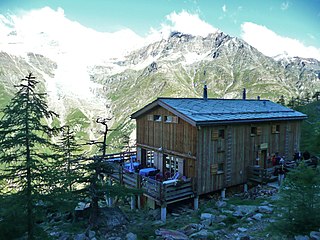
The Europa Hut is a mountain hut located in the Mattertal above Randa in the Mischabel range at 2,265 m, owned by the Swiss Alpine Club. It lies on the Grächen-Zermatt high trail, called Europaweg. From the hut a trail leads to the Dom Hut, on the normal route to the Dom.
The Stellihorn is a mountain of the Swiss Pennine Alps, located west of St. Niklaus in the canton of Valais. It lies north of the Barrhorn, on the range between the Turtmanntal and the Mattertal.

The Wyssegga is a mountain of the Swiss Pennine Alps, between the Turtmanntal and the Mattertal in the canton of Valais.

