Stickney, Kansas

Last updated

Stickney, Kansas
Map of Barton Co, Ks, USA.png
USA Kansas location map.svg
Red pog.svg
Stickney
Usa edcp location map.svg
Red pog.svg
Stickney
Coordinates: 38°38′17″N98°49′46″W / 38.63806°N 98.82944°W / 38.63806; -98.82944 [1]
Country United States
State Kansas
County Barton
Township Wheatland
Elevation
[1]
1,955 ft (596 m)
Time zone UTC-6 (CST)
  Summer (DST) UTC-5 (CDT)
ZIP code
67544
Area code 620
FIPS code 20-68250
GNIS ID 484733 [1]

Stickney is an unincorporated area in Wheatland Township, Barton County, Kansas, United States. [1] It is the site of a grain elevator, but there is no community or settlement at Stickney. [2]

Contents

History

A post office opened at Stickney in 1898 and remained in operation until 1913. [3]

Geography

Stickney is 1 mile (1.6 km) east of U.S. Route 281 and 19 miles (31 km) north of Great Bend, the county seat. [4]

Stickney lies roughly 1.5 miles (2.4 km) east of Sellens Creek, a tributary of the Smoky Hill River, in the Smoky Hills region of the Great Plains. [4] [5]

Transportation

Stickney lies at the intersection of NW 190 Road, a paved east–west county road, and NW 30 Avenue, an unpaved north–south county road. [4]

The Atchison, Topeka and Santa Fe Railway formerly operated a freight rail line that ran east–west through Stickney, but the line has since been removed. [4]

Related Research Articles

<span class="mw-page-title-main">Galatia, Kansas</span> City in Barton County, Kansas

Galatia is a city in Barton County, Kansas, United States. As of the 2020 census, the population of the city was 45.

<span class="mw-page-title-main">K-156 (Kansas highway)</span> Highway in Kansas

K-156 is a 175.663-mile-long (282.702 km) west–east state highway in the U.S. state of Kansas. K-156's western terminus is at U.S. Route 50 Business and US-83 Bus. in Garden City and the eastern terminus is at Interstate 70 (I-70) and U.S. Route 40 (US-40) northeast of Ellsworth. Along the way, it intersects several major highways including US-50, US-83 and US-400 in Garden City; US-283 in Jetmore; and US-183 near Rozel, and it overlaps its implied parent, US-56, from Larned to east of Great Bend.

<span class="mw-page-title-main">Pfeifer, Kansas</span> Unincorporated community in Ellis County, Kansas

Pfeifer is an unincorporated community in Freedom Township, Ellis County, Kansas, United States. It is located 10 miles (16 km) south of Victoria.

<span class="mw-page-title-main">Walker, Kansas</span> Unincorporated community in Ellis County, Kansas

Walker is an unincorporated community in Herzog Township, Ellis County, Kansas, United States. It is located between Hays and Russell, along old Hwy 40 on the north side of I-70. Walker has a post office with ZIP code 67674.

<span class="mw-page-title-main">Fairport, Kansas</span> Unincorporated community in Russell County, Kansas

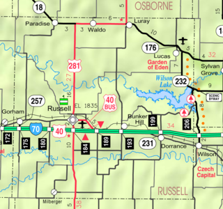
Fairport is an unincorporated community in Paradise Township, Russell County, Kansas, United States. It is located about 12 miles north of Gorham near the west county line and next the Saline River.

<span class="mw-page-title-main">Milberger, Kansas</span> Unincorporated community in Russell County, Kansas

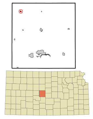
Milberger is an unincorporated community in Lincoln Township, Russell County, Kansas, United States. It is located about 10.5 miles south of Russell and 3.5 miles west of U.S. Route 281 on Michaelis Rd.

<span class="mw-page-title-main">Dubuque, Kansas</span> Unincorporated community in Barton and Russell Counties in Kansas

Dubuque is an unincorporated community in Barton and Russell Counties in the U.S. state of Kansas. It is approximately 10 miles (16 km) south of Dorrance.

<span class="mw-page-title-main">Emmeram, Kansas</span> Unincorporated community in Ellis County, Kansas

Emmeram is an unincorporated community in Herzog Township, Ellis County, Kansas, United States.

<span class="mw-page-title-main">Winterset Township, Russell County, Kansas</span> Township in Kansas, United States

Winterset Township is a township in Russell County, Kansas, United States. As of the 2010 United States Census, it had a population of 67.

<span class="mw-page-title-main">Big Creek Township, Russell County, Kansas</span> Township in Kansas, United States

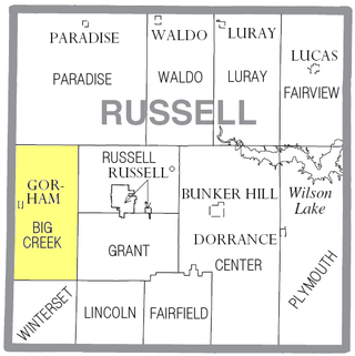
Big Creek Township is a township in Russell County, Kansas, United States. As of the 2010 United States Census, it had a population of 479.

<span class="mw-page-title-main">Center Township, Russell County, Kansas</span> Township in Kansas, United States

Center Township is a township in Russell County, Kansas, United States. As of the 2010 United States Census, it had a population of 221.

<span class="mw-page-title-main">Fairfield Township, Russell County, Kansas</span> Township in Kansas, United States

Fairfield Township is a township in Russell County, Kansas, United States. As of the 2010 United States Census, it had a population of 31.

<span class="mw-page-title-main">Lincoln Township, Russell County, Kansas</span> Township in Kansas, United States

Lincoln Township is a township in Russell County, Kansas, United States. As of the 2010 United States Census, it had a population of 150.

<span class="mw-page-title-main">Plymouth Township, Russell County, Kansas</span> Township in Kansas, United States

Plymouth Township is a township in Russell County, Kansas, United States. As of the 2010 United States Census, it had a population of 280.

<span class="mw-page-title-main">North Fork Smoky Hill River</span> River in Kansas, United States

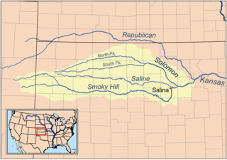
The North Fork Smoky Hill River is a river in the central Great Plains of North America. A tributary of the Smoky Hill River, it flows from eastern Colorado into western Kansas.

<span class="mw-page-title-main">Antonino, Kansas</span> Unincorporated community in Ellis County, Kansas

Antonino is an unincorporated community in Lookout Township, Ellis County, Kansas, United States.

<span class="mw-page-title-main">Toulon, Kansas</span> Unincorporated community in Ellis County, Kansas

Toulon is an unincorporated community in Big Creek Township, Ellis County, Kansas, United States. It is located east of Hays along old Hiway 40.

<span class="mw-page-title-main">Turkville, Kansas</span> Ghost town in Ellis County, Kansas

Turkville is a ghost town in Ellis County, Kansas, United States.

<span class="mw-page-title-main">Webster, Kansas</span> Unincorporated community in Rooks County, Kansas

Webster was an unincorporated community in Belmont Township, Rooks County, Kansas, United States.

<span class="mw-page-title-main">K-147 (Kansas highway)</span> State highway in Kansas

K-147 is an approximately 26-mile-long (42 km) north–south state highway in west-central Kansas. It runs from K-4 east of Brownell to Ogallah, just north of the junction with Interstate 70 (I-70) and U.S. Route 40 (US-40). K-147 serves Cedar Bluff State Park via locally maintained CC Road. The highway south of I-70 and US-40 is part of the Smoky Valley Scenic Byway. The highway travels through a mix of flat farmlands and rolling hills covered with grasslands. K-147 is a two-lane highway its entire length.

References

  1. 1 2 3 4 U.S. Geological Survey Geographic Names Information System: Stickney, Kansas
  2. "Stickney, KS [Street View]". Google Maps . Retrieved July 17, 2015.
  3. "Kansas Post Offices, 1828-1961". Kansas Historical Society. Archived from the original on October 9, 2013. Retrieved August 2, 2014.
  4. 1 2 3 4 "General Highway Map - Barton County, Kansas". Kansas Department of Transportation. 2009. Retrieved July 22, 2015.
  5. "2003-2004 Official Transportation Map" (PDF). Kansas Department of Transportation. 2003. Retrieved July 22, 2015.

Further reading