
A megalith is a large stone that has been used to construct a prehistoric structure or monument, either alone or together with other stones. There are over 35,000 in Europe alone, located widely from Sweden to the Mediterranean sea.

A stone circle is a ring of standing stones. Most are found in Northwestern Europe – especially in Britain, Ireland, and Brittany – and typically date from the Late Neolithic and Early Bronze Age, with most being built from 3000 BC. The best known examples include those at the henge monument at Avebury, the Rollright Stones, and elements within the ring of standing stones at Stonehenge. Scattered examples exist from other parts of Europe. Later, during the Iron Age, stone circles were built in southern Scandinavia.

The Coldrum Long Barrow, also known as the Coldrum Stones and the Adscombe Stones, is a chambered long barrow located near the village of Trottiscliffe in the south-eastern English county of Kent. Probably constructed in the fourth millennium BCE, during Britain's Early Neolithic period, today it survives only in a state of ruin.

The Medway Megaliths, sometimes termed the Kentish Megaliths, are a group of Early Neolithic chambered long barrows and other megalithic monuments located in the lower valley of the River Medway in Kent, South-East England. Constructed from local sarsen stone and soil between the 4th and 3rd millennia BCE, they represent the only known prehistoric megalithic group in eastern England and the most south-easterly group in Britain.

Cup and ring marks or cup marks are a form of prehistoric art found in the Atlantic seaboard of Europe (Ireland, Wales, Northern England, Scotland, France, Portugal, and Spain – and in Mediterranean Europe – Italy, Azerbaijan and Greece, as well as in Scandinavia and in Switzerland.
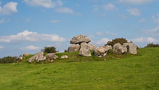
Carrowmore is a large group of megalithic monuments on the Coolera Peninsula to the west of Sligo, Ireland. They were built in the 4th millennium BC, during the Neolithic. There are thirty surviving tombs, making Carrowmore one of the largest clusters of megalithic tombs in Ireland, and one of the 'big four' along with Carrowkeel, Loughcrew and Brú na Bóinne. Carrowmore is the heart of an ancient ritual landscape which is dominated by the mountain of Knocknarea to the west. It is a protected National Monument.

The Xagħra Stone Circle, also known as the Xagħra Hypogeum or the Brochtorff Circle, is a Neolithic funerary complex located in Xagħra, Gozo, Malta. It consists of a series of caves which were used to bury the dead, and which were surrounded by a walled enclosure. It mainly dates back to around 3000 to 2400 BC, although the earliest tombs at the site date back to 4100 to 3800 BC. The caves collapsed sometime before 2000 BC, and the site was later used for domestic and agricultural purposes.
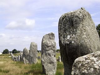
The Carnac stones are an exceptionally dense collection of megalithic sites near the south coast of Brittany in northwestern France, consisting of stone alignments (rows), dolmens, tumuli and single menhirs. More than 3,000 prehistoric standing stones were hewn from local granite and erected by the pre-Celtic people of Brittany and form the largest such collection in the world. Most of the stones are within the Breton municipality of Carnac, but some to the east are within neighboring La Trinité-sur-Mer. The stones were erected at some stage during the Neolithic period, probably around 3300 BC, but some may date to as early as 4500 BC.
Bohonagh is an axial stone circle located 2.4 km east of Rosscarbery, County Cork, Ireland. The circle is thought to date from the Bronze Age. A boulder burial is sited nearby.
This article describes several characteristic architectural elements typical of European megalithic structures.
Brahmagiri is an archaeological site located in the Chitradurga district of the state of Karnataka, India. Legend has it that this is the site where sage Gautama Maharishi and his wife Ahalya lived. He was one among seven noted Hindu saints. This site was first explored by Benjamin L. Rice in 1891, who discovered rock edicts of Emperor Ashoka here. These rock edicts indicated that the locality was termed as Isila and denoted the southernmost extent of the Mauryan empire. The Brahmagiri site is a granite outcrop elevated about 180 m. above the surrounding plains and measures around 500 m east-west and 100 m north-south. It is well known for the large number of megalithic monuments that have been found here. The earliest settlement found here has been dated to at least the 2nd millennium BC.
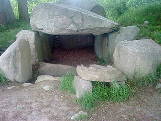
The Lancken-Granitz dolmens are a group of seven megalith tombs in the Lancken-Granitz municipality on Rügen, northern Germany. Erected during the middle Neolithic, when they were used by the Funnelbeaker culture, at least some were in use until the early Bronze Age. Three of them are encircled by solitary rocks forming either rectangles or a stone circle, one has a solitary "guardian stone" on its eastern side.

In the area of present-day Mecklenburg-Vorpommern, Germany, up to 5,000 megalith tombs were erected as burial sites by people of the Neolithic Funnelbeaker (TRB) culture. More than 1,000 of them are preserved today and protected by law. Though varying in style and age, megalith structures are common in Western Europe, with those in Mecklenburg-Vorpommern belonging to the youngest and easternmost—further east, in the modern West Pomeranian Voivodeship of Poland, monuments erected by the TRB people did not include lithic structures, while they do in the south (Brandenburg), west and north (Denmark).
Jorwe is a village and an archaeological site located on the Pravara, a tributary of the Godavari River in Sangamner taluka of Ahmednagar district of Maharashtra state in India. This site was excavated in 1950-51 under the direction of Hasmukh Dhirajlal Sankalia and Shantaram Bhalchandra Deo.
Byse is a village in the Shimoga district of Karnataka, India. It is located around 140 km from Mangalore, in the Nagara hobli of the Hosanagara taluka.
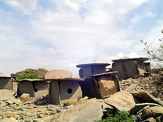
Hirebenakal or Hirébeṇakal or Hirébeṇakallu is a megalithic site in the state of Karnataka, India. It is among the few megalithic sites in India that can be dated to the 800 BCE to 200 BCE period. The site is located in the Koppal district, some 10 kilometres (6.2 mi) west of the town of Gangavati and some 35 kilometres (22 mi) from Hospet city. It contains roughly 400 megalithic funerary monuments, that have been dated to the transition period between Neolithic period and the Iron Age. Known locally as eḷu guḍḍagaḷu, their specific name is moryar guḍḍa. Hirebenakal is reported to be the largest necropolis among the 2000 odd megalithic sites found in South India, most of them in the state of Karnataka. Since 1955, it has been under the management of the Dharwad circle of the Archaeological Survey of India (ASI). On May 19, 2021, it was proposed that Hirebenakal be made a UNESCO World Heritage Site.

Hasmukh Dhirajlal Sankalia was an Indian Sanskrit scholar and archaeologist specialising in proto- and ancient Indian history. He is considered to have pioneered archaeological excavation techniques in India, with several significant discoveries from the prehistoric period to his credit. Sankalia received the Ranjitram Suvarna Chandrak award in 1966. And also received Padma Bhushan in the year 1974.
Kodayanallur Vadamamalachery Soundararajan is an Indian archaeologist who served as Superintendent of the Chennai circle and later, a Joint Director General of the Archaeological Survey of India. He was known for his pioneering work in excavating Stone Age and megalithic sites of South India along with Mortimer Wheeler and V. D. Krishnaswami in the late 1940s and the 1950s. Some of the sites excavated by Soundararajan include Sanur (1950), Kundrathur (1955–56), Perur (1970–71), Malayamputtu (1970–71) and Poompuhar.
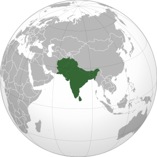
Archaeology in India is mainly done under the supervision of the Archaeological Survey of India.
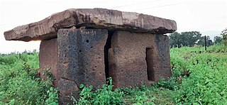
Hirapur dolmens, dating back to 2nd-3rd century BC asmaka mahajanapadas or satavahana dynasty era, are 4 dolmens made of megalithic laterite in the general area of Hirapur village on NH-930 in Chimur tehsil of Chandrapur district of Maharashtra.


