The Charlotte Area Transit System (CATS) is the agency responsible for public transportation in the Charlotte metropolitan area. CATS operates bus and rail transit services in Mecklenburg County and surrounding areas. Established in 1999, CATS' bus and rail operations carry about 320,000 riders on an average week. CATS is governed by the Metropolitan Transit Commission and is operated as a department of the City of Charlotte.

The Charlotte Trolley was a heritage streetcar that operated in Charlotte in the U.S. state of North Carolina. The line ran along the former Norfolk Southern right of way between Tremont Avenue in the Historic South End in a northerly direction to its terminus at 9th Street Uptown. It ran on tracks mostly shared with the LYNX Blue Line.

7th Street station is a light rail station for the LYNX Blue Line in Center City Charlotte, North Carolina, United States. It is located between 6th and 7th Streets; several privately operated parking decks and lots surround the station. Notable places nearby include Discovery Place, Hearst Tower, ImaginOn, Levine Museum of the New South, Main Public Library and the McGlohon Theatre at Spirit Square.
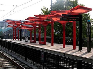
3rd Street/Convention Center is a light rail station in Charlotte, North Carolina. The elevated dual side platforms are a stop along the Lynx Blue Line in Uptown Charlotte.

The Charlotte Transportation Center (CTC), also known as Arena or CTC/Arena, is an intermodal transit station in Center City Charlotte, North Carolina, United States. It serves as the central hub for the Charlotte Area Transit System (CATS) buses and connects with the LYNX Blue Line and CityLYNX Gold Line. It is located on East Trade Street, Fourth Street and Brevard Street. Notable places nearby include the Bank of America Corporate Center, Belk Theater, EpiCentre, Overstreet Mall and the Spectrum Center.

I-485/South Boulevard is a light rail station in Charlotte, North Carolina. The elevated island platform is the southern terminus stop along the Lynx Blue Line and includes the second largest park and ride operated by Charlotte Area Transit System (CATS). Serving both Carolina Pavilion and Sterling neighborhood in the immediate area, it also serves commuters from Pineville, Ballantyne, and the South Carolina border towns.

Tyvola is a light rail station in Charlotte, North Carolina. The elevated island platform is a stop along the Lynx Blue Line and serves an area of mostly commercial and industrial businesses, with the neighborhoods of Madison Park and Montclaire located nearby. It also features a 464-space park and ride and local bus connections.

Archdale is a light rail station in Charlotte, North Carolina. The elevated island platform is a stop along the Lynx Blue Line and serves Montclaire South and nearby Montclaire and Starmount neighborhoods. It also features a 432-space park and ride and local bus connections.

Bland Street is a light rail station in Charlotte, North Carolina. The at-grade dual side platforms are a stop along the Lynx Blue Line and serves South End and nearby Dilworth neighborhood.

East/West Boulevard is a light rail station in Charlotte, North Carolina. The at-grade dual side platforms are a stop along the Lynx Blue Line and serves South End and nearby Dilworth and Wilmore neighborhoods.
Scaleybark is a light rail station in Charlotte, North Carolina. The at-grade dual side platforms are a stop along the Lynx Blue Line that serves the nearby neighborhoods of Colonial Village, Collingwood, and York Road.

Woodlawn is a light rail station in Charlotte, North Carolina. The at-grade dual side platforms are a stop along the Lynx Blue Line and serves an area of mostly commercial and industrial businesses, with the neighborhoods of Collingwood and Madison Park located nearby. It also features a 382-space park and ride and local bus connections.

Arrowood is a light rail station in Charlotte, North Carolina. The at-grade island platform is a stop along the Lynx Blue Line and serves Montclaire South and Starmount neighborhoods, as well as Central Piedmont Community College's Harper Campus. It also features a 289-space park and ride that includes local bus connections and intercity bus service via Megabus.

Sharon Road West is a light rail station in Charlotte, North Carolina. The at-grade island platform is a stop along the Lynx Blue Line and serves the industrial area of Montclaire South, including the Snyder's-Lance factory. It also features a 188-space park and ride and local bus connections.
The LYNX Silver Line is a proposed east-west light rail line in Charlotte, North Carolina. The Silver Line would connect the outlying cities and towns of Belmont, Matthews, Stallings and Indian Trail to Uptown Charlotte and the Charlotte Douglas International Airport. In the refined locally preferred alternative (LPA), released in early 2021, the route is estimated to be around 29 miles (47 km), with 29 stations and one maintenance facility.

9th Street is a light rail station in Charlotte, North Carolina. The at-grade dual side platforms are a stop along the Lynx Blue Line and serves Uptown Charlotte's First Ward as well as First Ward Park and the UNC Charlotte Center City Campus.
The transportation needs for the city of Charlotte, North Carolina are served by an expanding mass transit system, major airport, and several highways.

Charlotte Gateway Station is a future intermodal transit station in Charlotte, North Carolina, United States. Currently operating as a streetcar stop for the CityLynx Gold Line, it is the centerpiece of the overall 19-acre (7.7 ha) Station District and will feature an Amtrak intercity rail station, a Charlotte Area Transit System light rail and bus station and a Greyhound Lines intercity bus facility. The district will also include parking facilities, mixed-use development and an elevated greenway. Estimated at a cost of $800.1 million for full implementation of all public and private components, the project will be built in three phases, with all construction tentatively done by 2024.

The Lynx Blue Line is a light rail line in Charlotte, North Carolina. The first rail line of the Charlotte Area Transit System, it is the first major rapid rail service of any kind in the state. The 26-station, 19.3-mile (31.1 km) line extends from its northern terminus at the University of North Carolina at Charlotte in University City through NoDa, Uptown, and South End, then runs along South Boulevard to its southern terminus just north of Interstate 485 at the Pineville city limits. The line carries an average of over 27,700 passenger trips every day.

JW Clay Blvd/UNC Charlotte is a light rail station on the LYNX Blue Line in Charlotte, North Carolina, United States. It is located on North Tryon Street at JW Clay Boulevard in University City. The station consists of a single island platform in the street's median, connected via pedestrian overpass to both sides of North Tryon Street and to an adjacent parking garage. The parking garage charges a flat weekday fee for all riders that do not have a one-day, weekly or monthly pass. JW Clay Blvd/UNC Charlotte station is west of the University of North Carolina at Charlotte campus and is near Jerry Richardson Stadium. The station opened on March 16, 2018.

