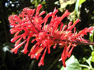
Acanthaceae is a family of dicotyledonous flowering plants containing almost 250 genera and about 2500 species. Most are tropical herbs, shrubs, or twining vines; some are epiphytes. Only a few species are distributed in temperate regions. The four main centres of distribution are Indonesia and Malaysia, Africa, Brazil, and Central America. Representatives of the family can be found in nearly every habitat, including dense or open forests, scrublands, wet fields and valleys, sea coast and marine areas, swamps, and mangrove forests.
Champawat is a town and a Nagar Palika Parishad in Champawat district in the state of Uttarakhand, India. It is the administrative headquarters of Champawat district. The town was the former capital of the Kumaon Kingdom.
Almora district is a district in the Kumaon division of Uttarakhand state, India. The headquarters is at Almora. It is 1,638 meters above sea level. The town of Almora is surrounded by Pithoragarh district to the east, Garhwal region to the west, Bageshwar district to the north and Nainital district to the south.

Pithoragarh district is the easternmost Himalayan district in the state of Uttarakhand, India. It is naturally landscaped with high Himalayan mountains, snow-capped peaks, passes, valleys, alpine meadows, forests, waterfalls, perennial rivers, glaciers, and springs. The flora and fauna of the area have rich ecological diversity. Pithoragarh has many temples and ruined forts from the once flourishing reign of the warrior Chand Kingdom.
Didihat is a town and a Nagar Palika in Pithoragarh District in the state of Uttarakhand, India. It is one of the eleven administrative subdivisions of Pithoragarh district and also serves as its administrative headquarters. With a population of 6522, Didihat is located at a distance of 520 km (320 mi) from the state capital Dehradun.

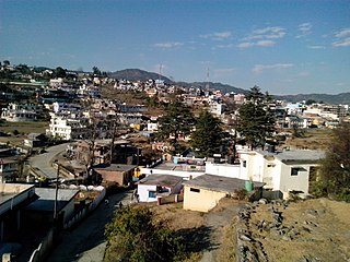
Pithoragarh is a western Himalayan town with a Municipal Board in Pithoragarh district in the Indian state of Uttarakhand. It is the largest unorganised village cluster in the hills of Uttarakhand. This place is strategically important from defense point of view for India as the district shares international boundaries with China and Nepal.

Bageshwar District is a district of Uttarakhand state in northern India. The town of Bageshwar is the district headquarters. The district of Bageshwar was established in the year 1997. Prior to this, Bageshwar was part of Almora district.

Kurinji or Neelakurinji is a shrub that is found in the shola forests of the Western Ghats in South India. Nilgiri Hills, which literally means the blue mountains, got their name from the purplish blue flowers of Neelakurinji that blossoms only once in 12 years. Of all long interval bloomers Strobilanthes kunthianus is the most rigorously demonstrated, with documented bloomings in 1838, 1850, 1862, 1874, 1886, 1898, 1910, 1922, 1934, 1946, 1958, 1970 1982, 1994, 2006 and 2018
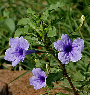
Ruellia is a genus of flowering plants commonly known as ruellias or wild petunias. They are not closely related to petunias (Petunia) although both genera belong to the same euasterid clade. The genus was named in honor of Jean Ruelle, herbalist and physician to Francis I of France and translator of several works of Dioscorides.

Lohaghat is a town and a nagar panchayat in Champawat district in the Indian state of Uttarakhand. Lohaghat is a very beautiful hill station with many tourist spots around.
Berinag, is a hill station, located 160 km from Nainital in the Pithoragarh district, which is the easternmost Himalayan district in the state of Uttarakhand, India. It is one of the six Administrative Subdivisions (tehsil) of Pithoragarh. National Highway 309A passes through Berinag. Closest prominent villages include Garawon, Dhanoli, Bana, Bhattigaon, Banoli, Quarali, Tripuradevi and Sangarh.

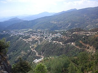
Chaukori is a hill station in the Pithoragarh district set among the lofty peaks of the western Himalayan Range in the Kumaon Division of Uttarakhand, India. To its north is Tibet and to its south is Terai. The Mahakali River, running along its eastern boundary, forms the Indo-Nepal international border. This place has become a prominent tourist place and from here a wide and picturesque view of Himalayan range can be viewed. The golden yellow colour of sun rays falling on the Himalayan range in the morning time is really worth seeing. There are cottages available here where one can stay and enjoy the serene surroundings. Tourists coming to this place generally also visit the nearby tourist places like Patal Bhuvaneshwar, Kausani, Bageshwar and Almora.
Strobilanthes callosa Nees (Synonym: Carvia callosa Bremek) is a shrub found mainly in the low hills of the western ghats all along the west coast of India. Its standardized Hindi language name is Maruadona (मरुआदोना) by which it is called in the state of Madhya Pradesh where it is also found. In the state of Maharashtra in the Marathi language and other local dialects and in the neighboring state of Karnataka the shrub is locally known as Karvi, sometimes spelled in English as Karvy.

Kanda is a small historic, scenic town and tehsil in Bageshwar district, in the state of Uttarakhand, India.

National Highway 9 is a National Highway in India in east-west direction. It starts at Malaut in Punjab and ends at Askot in Pithoragarh district in Uttarakhand. It passes through the states of Punjab, Haryana, Delhi, Uttar Pradesh and Uttarakhand. After renumbering of all national highways by National Highway Authority of India in 2010, the current NH 9 was formed by merging segments of five separate national highways in 2010; these were Old NH 10, Old NH 24, Old NH 87, Old NH 74 and Old NH 125.

Kandali Tarf Rahur is a village in the Thane district of Maharashtra, India. It is located in the Bhiwandi taluka. It is situated between AH47 and the Bhatsa River.
Strobilanthes penstemonoides is a species flowering plant in the acanthus family (Acanthaceae). It occurs in China, Bhutan, India, and Nepal. Its specific epithet has been spelled as penstemonoides, pentstemonoides, and pentastemonoides.
Strobilanthes wightianus is a species of plant belongs to the Strobilanthes genus of the Acanthaceae family, commonly called the "Wight's kurinji". It is endemic to Southern Western Ghats. It prefers evergreen and semi-evergreen forests.


