Stuarts Creek, South Australia

Last updated

Stuarts Creek
South Australia
Curdimurka.jpg
Australia South Australia location map.svg
Red pog.svg
Stuarts Creek
Coordinates 29°38′S137°03′E / 29.63°S 137.05°E / -29.63; 137.05 Coordinates: 29°38′S137°03′E / 29.63°S 137.05°E / -29.63; 137.05
Postcode(s) 5720 [1]
LGA(s) Pastoral Unincorporated Area [1]
State electorate(s) Giles [1]
Federal Division(s) Grey [1]
Localities around Stuarts Creek:
Anna Creek Lake Eyre Lake Eyre
Muloorina
Billa Kalina Stuarts Creek Lake Eyre
Callanna
Witchelina
Parakylia Roxby Downs Station Mulgaria
Andamooka Station
Footnotes Coordinates [2]

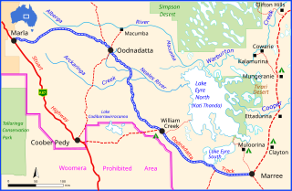
Stuarts Creek is a remote locality in the Far North region of South Australia. It lies in the state's Pastoral Unincorporated Area. [1] The name and boundaries were formalised on 26 April 2013, named after Stuart Creek Station, in respect of the long established local name. [2]

Far North (South Australia) Region in South Australia

The Far North is a large region of South Australia close to the Northern Territory border. Colloquial usage of the term in South Australia refers to that part of South Australia north of a line roughly from Ceduna through Port Augusta to Broken Hill. The South Australian Government defines the Far North region similarly with the exception of the Maralinga Tjarutja Lands. the Yalata Aboriginal Reserve and other unincorporated crown lands in the state's far west, which are officially considered part of the Eyre and Western region.

South Australia State of Australia

South Australia is a state in the southern central part of Australia. It covers some of the most arid parts of the country. With a total land area of 983,482 square kilometres (379,725 sq mi), it is the fourth-largest of Australia's states and territories by area, and fifth largest by population. It has a total of 1.7 million people, and its population is the second most highly centralised in Australia, after Western Australia, with more than 77 percent of South Australians living in the capital, Adelaide, or its environs. Other population centres in the state are relatively small; Mount Gambier, the second largest centre, has a population of less than 30,000.

Stuart Creek Station

Stuart Creek Station is a pastoral lease that once operated as a sheep station but now operates as a cattle station in outback South Australia.

It includes the former settlement of Coward Springs. [2] The Wabma Kadarbu Mound Springs Conservation Park lies in the north-west of the locality. [1] [2]

Coward Springs South Australia

Coward Springs is a former settlement and railway station in the desert in the Far North of South Australia, which has been privately developed as a camping ground. The name officially refers to a mound spring located nearby. It is situated on the Oodnadatta Track adjacent to the Wabma Kadarbu Mound Springs Conservation Park, within the current locality of Stuarts Creek, 236 kilometres (147 mi) from Coober Pedy.

Wabma Kadarbu Mound Springs Conservation Park Protected area in South Australia

Wabma Kadarbu Mound Springs Conservation Park is a protected area in the Australian state of South Australia. It is located in Stuarts Creek, about 130 kilometres north of the town of Marree via the Oodnadatta Track in the state's Far North. The conservation park was proclaimed under the National Parks and Wildlife Act 1972 in 1996. As of 2012, it is subject to a co-management agreement between the Arabana aboriginal people and the Department of Environment, Water and Natural Resources

The Central Australia Railway (often referred to as the "Old Ghan") ran through Stuarts Creek, with former stations or sidings at Coward Springs, Margaret, and Stuart Creek (later Curdimurka) all within its current boundaries. The railway remnants at Coward Springs and Curdimurka are both listed on the South Australian Heritage Register. [1] [2]

Central Australia Railway railway line

The former Central Australia Railway was a 1241 km 1067 mm narrow gauge railway between Adelaide and Alice Springs. A standard gauge line replaced the southern section from Port Augusta to Maree in 1957, but used a new nearby alignment. The entire line was superseded in 1980 by the wholly standard gauge Adelaide-Darwin railway, using a new route up to 200 km to the west. A small southern section of the original line between Port Augusta and Quorn has been preserved as the Pichi Richi Tourist Railway. A short section just south of Alice Springs has also been preserved.

The South Australian Heritage Register is a statutory register of historic places in South Australia. It extends legal protection regarding demolition and development under the Heritage Places Act 1993. It is administered by the South Australian Heritage Council. As a result of the progressive abolition of the Register of the National Estate during the 2000s and the devolution of responsibility for state-significant heritage to state governments, it is now the primary statutory protection for state-level heritage in South Australia.

Heritage listings

Stuarts Creek has a number of heritage-listed sites, including:

Related Research Articles

Ikara-Flinders Ranges National Park Protected area in South Australia

The Ikara-Flinders Ranges National Park is situated approximately 400 km north of Adelaide in the northern central part of South Australia's largest mountain range, the Flinders Ranges. The park covers an area of 912 km², northeast of the small town of Hawker. The Heysen Trail and Mawson Trails pass through the park.

Lake Gairdner National Park Protected area in South Australia

Lake Gairdner National Park is a protected area associated with Lake Gairdner in South Australia (Australia), 436 km northwest of Adelaide. It is located just south of the Trans-Australian Railway, Stuart Highway, and the Woomera Prohibited area.

Port Augusta City in South Australia

Port Augusta is a small city in South Australia. Formerly a seaport, it is now a road traffic and railway junction city mainly located on the east coast of the Spencer Gulf immediately south of the gulf's head and about 322 kilometres (200 mi) north of the state capital, Adelaide. The suburb of Port Augusta West is located on the west side of the gulf on the Eyre Peninsula. Other major industries included, up until the mid-2010s, electricity generation. At June 2015, the estimated urban population was 14,214.

Oodnadatta Track track in South Australia

The Oodnadatta Track, Australia is an unsealed 617 km (383 mi) outback road between Marree and Marla via Oodnadatta in South Australia. Along the way, the track passes the southern lake of the Kati Thanda-Lake Eyre National Park, and the outback settlements of William Creek and Oodnadatta.

Quorn, South Australia Town in South Australia

Quorn is a township and railhead in the Flinders Ranges in the north of South Australia, 39 km northeast of Port Augusta. At the 2016 census, the locality had a population of 1,230 of which 1,131 lived in its town centre.

Peterborough, South Australia Town in South Australia

Peterborough is a town in the mid north of South Australia, in wheat country, just off the Barrier Highway. At the 2016 census, Peterborough had a population of 1,416. It was originally named Petersburg after the landowner, Peter Doecke, who sold land to create the town. It was one of 69 places in South Australia renamed in 1917 due to anti-German sentiments during World War I.

Terowie, South Australia Town in South Australia

Terowie is a small town in the mid-north of South Australia located 220 kilometres (137 mi) north of the state capital of Adelaide. It is located in the Regional Council of Goyder. Terowie retains a number of authentic and well preserved 1880s buildings, and has been declared a "historic town". It also remains a town of interest to those interested in rail history. Although now a very small town with few facilities, Terowie remains a popular destination for photographers, historians, and rail buffs. At the 2016 census, Terowie had a population of 131.

Hawker, South Australia Suburb of Flinders Ranges Council, South Australia

Hawker is a town and a locality in the Flinders Ranges area of South Australia, 365 kilometres (227 mi) north of Adelaide. It is in the Flinders Ranges Council, the state Electoral district of Stuart and the federal Division of Grey. At the 2016 census, the locality had a population of 341 of which 237 lived in its town centre.

Truro, South Australia Town in South Australia

Truro is a town in South Australia, 80 km northeast of Adelaide. It is situated in an agricultural and pastoral district on the Sturt Highway, east of the Barossa Valley, where the highway crosses somewhat lofty and rugged parts of the Mount Lofty Ranges. At the 2011 census, Truro had a population of 395.

Melrose, South Australia Town in South Australia

Melrose is the oldest town in the Flinders Ranges. It is in the shadow of Mount Remarkable, 265 km north of Adelaide, and the town was once named "Mount Remarkable". At the 2011 census, Melrose had a population of 406.

Penola, South Australia Town in South Australia

Penola is a town in the Australian state of South Australia located about 388 kilometres (241 mi) southeast of the state capital of Adelaide in the wine growing area known as the Coonawarra. At the 2006 census, Penola had a population of 1,317.

Ooldea, South Australia Town in South Australia

Ooldea is a tiny settlement in South Australia. It is on the eastern edge of the Nullarbor Plain, 863 km (536 mi) west of Port Augusta on the Trans-Australian Railway. Ooldea is 143 km (89 mi) from the bitumen Eyre Highway.

Innamincka, South Australia Town in South Australia

Innamincka is a small settlement in north-east South Australia, with a population of only 12. It is 821 kilometres north-east of Adelaide and 365 kilometres north-east from the closest town, Lyndhurst. It is also 66 kilometres north-east of the Moomba Gas Refinery. The town lies within the Innamincka Regional Reserve and is surrounded by the Strzlecki Desert to the south and the Sturt Stony Desert to the north. The township is situated along the Cooper Creek, a part of the Lake Eyre Basin.

Blanchetown Town in South Australia

Blanchetown is a small township in South Australia, on the (west) bank of the Murray River, 130 km northeast of Adelaide. The Blanchetown Bridge is the western-most of the four crossings of the Sturt Highway over the Murray River. During the nineteenth century it was an important transportation centre on the lower Murray. In modern times Blanchetown has been described as "a strange mixture of historic buildings and temporary shacks built by holidaymakers on the banks of the river". Blanchetown is widely regarded as the entrance to the Riverland district.

Palmer, South Australia Town in South Australia

Palmer is a town just east of the Adelaide Hills region of South Australia along the Adelaide-Mannum Road, 70 kilometres east-north-east of the state capital, Adelaide and 15 km west-north-west of Mannum. It is located in the Mid Murray Council local government area. At the 2006 census, Palmer had a population of 329.

Kanyaka, South Australia Town in South Australia

Kanyaka is a rural locality in the Far North region of South Australia, situated in the Flinders Ranges Council.

Merty Merty

Merty Merty is both a pastoral lease that once operated as a cattle station in north east South Australia. In April 2013, the land occupying the appropriate extent of the pastoral lease was gazetted by the Government of South Australia as a locality under the name Merty Merty.

Flinders Ranges, South Australia Suburb of Flinders Ranges Council, South Australia

Flinders Ranges is a locality in the Australian state of South Australia located in the mountain range of the same name, about 380 kilometres north of the state capital of Adelaide, about 86 kilometres north-east of the municipal seat of Quorn and about 131 kilometres north-east of the centre of Port Augusta in the state’s Far North region.

References

  1. 1 2 3 4 5 6 7 8 9 10 11 "Search result(s) for Stuarts Creek, 5720". Location SA Map Viewer. Government of South Australia. Retrieved 16 February 2016.
  2. 1 2 3 4 5 "Search result(s) for Stuarts Creek, 5720". Property Location Browser. Government of South Australia. Retrieved 17 February 2016.
  3. "Coward Springs Railway Site, including the railway station master's house, the engine driver's cabin, the original bore, rainwater tanks, date palms and tamarisk trees". South Australian Heritage Register. Department of Environment, Water and Natural Resources. Archived from the original on 15 February 2016. Retrieved 11 February 2016.
  4. "Former Mount Hamilton Station Site (Ruins) (designated place of archaeological significance), Wabma Kadarbu Mound Springs Conservation Park". South Australian Heritage Register. Department of Environment, Water and Natural Resources. Retrieved 11 February 2016.
  5. "Curdimurka (formerly Stuart Creek) Railway Siding Complex, including fettlers' quarters, water treatment plant, water tank and Stuart Creek Bridge [Metal Girder]". South Australian Heritage Register. Department of Environment, Water and Natural Resources. Retrieved 11 February 2016.
  6. "Tertiary Silcrete Flora, Stuarts Creek". South Australian Heritage Register. Department of Environment, Water and Natural Resources. Retrieved 11 February 2016.